|
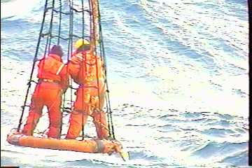
20 April, 1999Volcano and Vent Aficianados: I’d like to jump back to station 2 from yesterday for a moment. It was a station at which an uncontaminated surface water sample was desired by Dr. Carol Chin. Problem is, it is difficult to obtain clean surface water with a rosette system, so you have to “hand-sample,” preferably away from the water immediately near the ship. Since the winds and waves kicked up, she would not be able to go out in the zodiac inflatable boat, so she would have to go out in the "basket," at the end of the ship’s crane boom. Her colleague, Chi Meredith, would do the necessary tests to verify the water was uncontaminated. With high winds and building seas, it was difficult for the crane operator to maintain a steady height for Dr. Chin’s basket…attempting to do so turned water sampling into an adventure, as the attached picture will show. I later asked Dr. Chin what it was that interested her in marine science. I found out that Dr. Chin was studying geology at University of Southern California when she was invited to help out on an oceanographic cruise. She loved it and decided to pursue oceanography, having since parcticipated in over 20 cruises and winding up with a Ph.D. in marine geology. Dr. Chin now works at OSU as a research faculty member and as co-coordinator of the U.S. RIDGE Office, an organization working to foster collaboration between mid-ocean ridge scientists. Today we were up at 5 AM to gather more water samples and conductivity/temperature/depth measurements (CTD, which I later saw the value of when they were used to verify the in situ measurements made from the towed ZAPS sled). Then we were asked to sign up for watchstanding, which involved monitoring and logging the ship’s computer systems, the ship’s position, and the data for weather and seawater (needed to keep the ship’s sonar accurate, since sonar measures depth by bouncing a sound wave off the bottom and rate at which the wave travels is affected by ocean temperature and salinity). After signing up for the 4-6 AM slot (allowing me to get it out of the way and not interfere with the daylight activities and sights…as well as allow me to be early for the great breakfasts everyday!), I worked on ping editing (see April 16 for an explanation of ping editing) and then had dinner. After dinner, I met with Anke Daehlmann, of the European GEOMAR group (more on this later) to discuss my assisting their sampling the water found in the bottom sediments. Basically, they would sample the floor of the ocean by dropping a heavy, camera-guided “TV-Grab” on the end of a cable onto a site of their choosing and close it hydraulically, then bring the sediments/rocks back to the deck. Here, they would core the sample (by coring, I mean they will push a hollow container, like a tube, through the moist sediment, forcing sediment into the tube) and then take the core to the lab. Here is where I would be assisting - After the core is sliced into layers, I will take each layer and place it in a press, like an orange squeezer, and squeeze the water out of the sediment. They call this “pore water.” The water will be collected and analyzed for silicates (the stuff that makes up most of our sand and glass, but in the deep ocean it comes from dead diatoms - little microorganisms that make beautiful, ornate exteriors - kind of like their skeleton - out of the chemical silicon in the ocean), ammonium, phosphate, and sulfides (sulfur compounds that may come from the vent). After this meeting, I went to bed (11 PM). I had to be up at 330 AM to prepare for my watch. As I started to fade off, I noticed the video from the back deck camera (there are several channels of nothing but great science stuff - velocity, pressure, direction, bearings, depth, and video of many of the action areas of the ship - the back deck, side decks, front deck and bow). They were beginning to recover a dredge that had been pulled for several hours (I told you…science things are happening around the clock here…it’s tough for a science fan to pace him or herself in a situation like this…). They had been pulling a chain bag along the bottom for a few hundred meters to see what kind of rocks were there. The Bransfield Strait has been very active volcanically in the past and by studying the rocks, they will learn what kind of volcanic eruptions occurred, how long ago, and other information. I looked at the clock and decided I could trade some sleep time for this cool science stuff. Who knows what would come up in that chain dredge? Rocks? Ore? Some unidentified creature? Sure enough, there were cool volcanic rocks (which and even a few organisms called ascidians, organisms that made their jelly like house to live in and then either floated free, sucking in nutrients out of the water or connected one to the other in a long chain (that resembled a snake, in fact, when I first saw them, I swore they were red rat snakes swimming in the frigid Antarctic waters!). It turns out that the rocks they pulled up were similar to other rocks pulled up at Hook Ridge and Three Sisters (other topographically interesting sites that suggested volcanic histories). Dr. Randy Keller (I'll introduce him later), the geologist in charge of this operation, says that this seems to indicate that volcanism was widespread throughout the Bransfield Strait. Well, this impromptu midnight science fieldtrip cost me an hour, but it was worth it…until I got a phone call just as I was fading asleep again - the science support group had asked where my latest edited ping file was and since I had been on deck just 30 minutes ago they were sure I was still awake…well, I was now. I had planned on editing it during my watch, but since that was just a few hours away and the data was needed soon for the mapping of the region we were working, I ended up editing until just before my watch. A quick catnap and back up for watch! Well, that’s all for now, except the weather data and a Q&A. Take care, until tomorrow, Shawn **************************************************************************** *** Question: Our Third Grade class in western Pennsylvania is closely watching your experience in Antarctica!! We look forward to each piece of news you send. Just think-you're on the bottom of the world.... We have a question for you. Since our country measures by F for degrees in temperature and you measure in C, how can we easily convert to figure out your temperature? Can you help us please? Answer: My students and I studied that before I left... I’ve emailed your question to them just to see what they can do, but to allow you guys to make use of the data, try F = 9/5C + 32 In other words, if the temperature is 20C, multiply 20*9/5 = 36 and then add 32 = 68 F By the way, there is another grade school teacher aboard, Ms. Klinkhammer (her website is http://zora.oce.orst.edu/zaps ). Check it out…It’s…as our favorite Science Guy would say…”Way Cool!” Depth Lat. (S) Long (W)Date Time Temp Baro Wind /direction salinity (m) deg min deg min gmt (C) mbar m/s - degrees ppt 1558 62 10.3 57 17.8 4/20/99 1259 0.3 986.7 8 0 34.1 1148 62 12.2 57 11.3 4/20/99 1837 0.5 985.3 8.3 320 34.1
Contact the TEA in the field at . If you cannot connect through your browser, copy the TEA's e-mail address in the "To:" line of your favorite e-mail package. |