|
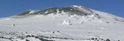
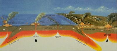
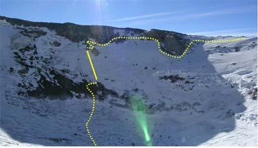
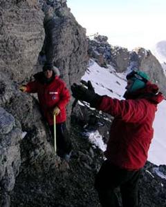
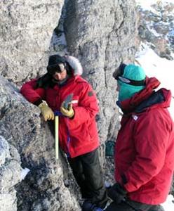
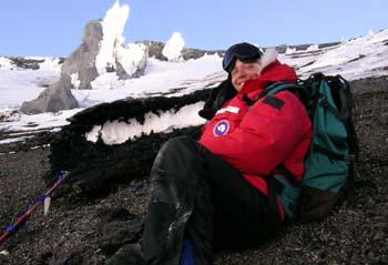
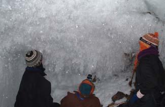
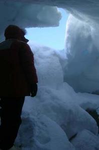
9 December, 2003The Side Crater Dr. Kurt Panter, from Bowling Green State University in Ohio, and his undergraduate student, Brian Winter, are working on ErebusÆs side crater this season. Currently inactive, this smaller, lower crater (Figure 1) has not been studied in detail before, so Brian is mapping the outcrops and collecting rock samples in an attempt to interpret the volcanic history. As gas sampling (see 12/08/03 Pumping Station) is important to understanding the current activity on Erebus, interpreting historical eruptions and possible magmatic intrusions adds to our understanding of volcanism in Antarctica. Volcanic activity in Antarctica, New Zealand, and Australia has been interpreted in several ways. One argument for the presence of Mt. Erebus and related volcanoes is that the plate is rifting, or pulling, apart as the result of extensional Plate Tectonic forces, much like the East African Rift System (Figure 2a). This stretching and thinning of the lithosphere (crust plus uppermost mantle) decreases the pressure on the underlying mantle and allows it to melt. This melted mantle is more buoyant and rises to the surface through conduits and is expressed as volcanic activity. A contrasting theory is that a deep mantle plume (much like the intraplate plume that feeds Hawaii) is rising to the surface in this region (Figure 2b). There are arguments that this plume was actually responsible for the break up of Gondwanaland (including Antarctica, Australia, New Zealand, and Tasmania) and now continues to feed Erebus. A third scenario suggests that an ancient spreading center, the Phoenix Ridge, was subducted beneath the Antarctic plate. A downgoing lithospheric slab reached neutral buoyancy and sat above the point at which it would descend into the lower mantle. At some later time, this slab collapsed into the lower mantle and caused an upwelling of hot mantle, which worked its way up to the surface to cause melting over a wide geographic area. Understanding more about ErebusÆs past activity will contribute to the understanding of why volcanism occurs in this area. Kurt and Brian are looking at the geochemistry of the rocks around Erebus. The chemical signals recorded in the rocks indicate where the magma originated in the mantle. If the magma was derived from melted mantle that sat close to the surface and then was recycled deeper into the Earth, the signal would look different than if the magma originated from a lithospheric plate melted in a subduction zone. This information may help answer questions regarding the underlying causes of volcanism as discussed above. I accompanied the Bowling Green team on a mapping trip to the side crater. Our route took us up the outside of the crater, along the rim, and down into the crater to collect samples from several outcrops (Figure 3). Kurt and Brian colleted specimens from each outcrop for analysis in the lab (Figures 4 and 5). We found that the fastest way down to the floor of the crater was to do a controlled self-arrest. A self-arrest is a method of stopping a fall down a steep, snowy or icy slope. You throw your weight over onto the head of your ice axe, which you bury point-down in the snow. Weighting the ice axe brings you to a stop. We intentionally slid down a steep slope and self-arrested at the bottom before reaching rocks again. You can see our self-arrest route along the solid line on Figure 3. While done in a safe and controlled manner on good snow, it was a steep enough slope to get our heart rates up! As we recovered from the excitement of our slide, we took some time to take a look around at old lava bombs, ejected from the main crater. In Figure 6, the lava bomb has retained its hollow core. As the lava is ejected from the main crater (a gas slug rising to the surface and bursting throws lava out of the lake), the gasses in the lava expand due to decreased pressure. This expanding gas leaves a hollow center in the bomb and creates a spindly, fibrous glassy texture as the gas continues to expand through the lava. After a few hours of exploring the side crater it was back to the hut for dinner and a little ice caving before bed. In contrast to last nightÆs caving adventure, tonightÆs was pretty easy. Last night we had rappelled into a brand new cave that no one has investigated before. We were treated to the most glorious display of ice crystal formations ¢ everything from perfect hexagonal crystals that show multiple growth layers to ice stalactites and stalagmites which mirror formations found in limestone caves (Figure 7). A short climb out was made challenging by a small overhang at the lip of the cave. TonightÆs cave, in contrast, was a nice walk through a winter wonderland. Large rooms connected by tighter squeezes made for adventure without the exhausting climb out. An investigation of one tight squeeze revealed a small, low room, but unfortunately did not lead to new passages (Figure 8). With my fill of self-arresting and caving for the night, I slept warm in my ¢55 degree down sleeping bag, one hot water bottle at my feet and one tucked under my arm. I drifted off looking forward to packing gear up RayÆs Gully tomorrow to help install the new seismic station.
Contact the TEA in the field at . If you cannot connect through your browser, copy the TEA's e-mail address in the "To:" line of your favorite e-mail package. |