|
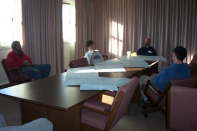
19 March, 2002Five scientists look with deep concentration at four, large topographic maps that lay strewn across the table. It's trip planning time... The last minute details of the trip route must be shared with all members of the team. The route must be carefully planned and organized. Not only for travel purposes but also to ensure that the scientific measurements are taken at the appropriate places. GPS (global positioning system) measurements will be used to navigate our route. The GPS works by reading longitude and latitude coordinates that are transmitted from satellites. These satellites orbit the Earth and are constantly taking readings. There are approximately 100 sites that we will take measurements at along the route. These sites are all known by their longitude and latitude coordinates. The methods and techniques of taking the scientific measurements was also discussed. Some of the instruments require careful handling for the measurements to be recorded accurately. It is much easier to go over the methods of taking measurements in a nice, warm room rather than the cold Arctic air. Plans for visits to the 6 native villages was also discussed. Last but definitely not least, safety issues were gone over in detail! We want to have a safe and successful expedition!!!! The SnowStar 2002 expedition is ready for departure to Nome tomorrow !!!. So- the next two days will be long, traveling days. We are very anxious, and excited to begin!!!!
Contact the TEA in the field at . If you cannot connect through your browser, copy the TEA's e-mail address in the "To:" line of your favorite e-mail package. |