|
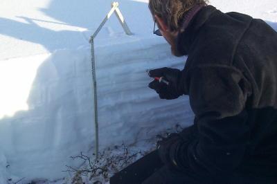
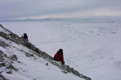
13 April, 2002Shovel in hand, the hard slab of snow is cut and then dug. Dig, dig, dig and then dig some more. Dig until there is no more snow showing, just the ground. Plop, sit down at the bottom of the pit with whisk broom and measuring ruler in hand and study the snow. A snow pit has just been dug and will soon be analyzed. Matthew has probably dug and analyzed more snow pits than any other person in the world. He definitely has dug more than any of us on this traverse. At the beginning of every 100-meter line, one primary snow pit is dug and meticulously analyzed. Also along the 100-meter line, quick snow pits are dug. A pit is dug at 25, 50, 75, and 100 meters. One person, who has often been me, digs all of the quick pits. This is a sure way to warm up the body especially when there is 50 cm of snow on the ground and the air temperatures are well below freezing. Matthew carries a black box that resembles a medical doctor's box. Inside of this box is all of his equipment to study the snow and analyze the snow pits. In this area of the Arctic, all of the snow that has fallen since about September remains on the ground. The snow may have changed form and structure depending on the temperature, humidity and wind. The snow ends up layering on top of one another forming the snowpack. The snowpack can be read like a book, sending messages about the weather for the year. Matthew reads each of these layers, deciphering the climate-related clues (such as temperature, wind, and precipitation histories) they hold. WHERE IS MRS. CHEUVRONT???? LET'S PLOT!!! Latitude: 68.48202 degrees North Longitude: 155.75247 degrees West Ivotuk - our safe cabin on the prairie. It sets alone, isolated on the plains of the Arctic. South of the cabin is the beginning of the Brooks Range Mountains. The mountains tower with their white, sharp, jagged peaks. The cabin provided needed safety during the ground blizzard yesterday. Today the storm has passed but clouds filtered the sky. The morning started with a retreat to an eroded hillside that has exposed sedimentary rocks. Hidden within the rocks are marine fossils dating back millions of years. The fossils are mainly brachiopod fossils, small shelled organisms. These animals are evidence that these rocks were once deposited in a marine, ocean environment. These fossils are tangible evidence that climate change has occurred over millions of years. Sitting on the cliffside, staring out across the horizon at the snow-covered mountains peaks with the wind stinging my face; it was hard to imagine that this area was once a warm, ocean environment. The Earth is full of changes. A complete snow-measurement site was finished in the afternoon, along with multiple GPS/MagnaProbe lines. The afternoon ended with a return to the small cabin. Another storm had come upon us bringing snow and blowing winds. The cabin welcomed us in from the cold with the promise of a warm meal and a warm bed. It was good and comforting to have the Ivotuk cabin as home instead of an exposed tent. Temperature max: -7 degrees Celsius Temperature min: -4 degrees Celsius Matthew Sturm USA-CRREL-Alaska P.O. Box 35170 Ft. Wainwright, AK 99703 907-353-5183 msturm@crrel.usace.army.mil
Contact the TEA in the field at . If you cannot connect through your browser, copy the TEA's e-mail address in the "To:" line of your favorite e-mail package. |