|
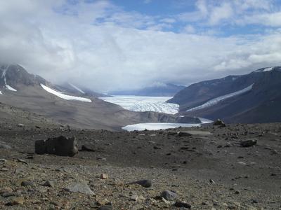
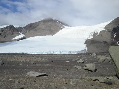
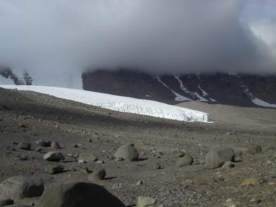
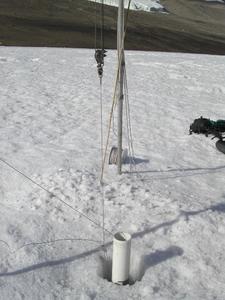
12 January, 2003Lake Bonney - Rock Collecting Near Sollas Glacier We all slowly dragged ourselves into the cook tent one by one this morning, eyes at half-mast. Everyone was exhausted from the previous day's work of breaking down camp and establishing a new camp on the hillside of Lake Bonney's eastern lobe. During breakfast (It's Sunday so that meant pancakes.) Chris gave us our assignments for the day. One team would go onto the ice to begin boring through the ice and the other team would set off to collect rocks and minerals. The ice team's goal for the day was to drill through the ice. For this they used the jiffy auger which is motorized. We had used this the first day at Lake Fryxell, but the ice there was quite different. There, the jiffy auger required many people to handle it, and the engine quickly overheated. However, the ice at Lake Bonney is what they call candle ice and when you drill it, the pieces come off in long shards. In lakes, ice crystals form perpendicular to the lake surface. Then, as the sun hits the surface of the lake, areas between crystals melt out, thereby making drilling easy as shards of ice crystals break away. However, because Fryxell once contained a snow cover, light cannot penetrate as well and so the ice remains denser. The ice team spent the remainder of the day feeding 39 meters (127 feet) of PVC pipe down through the hole to create a casing. The idea on this lake is to send a corer, lowered by extension poles, into the casing. A casing would help prevent bending of the extension poles and oblong rod when coring at such deep levels. (This lake is nearly twice as deep as Lake Fryxell.) Connecting 13 pieces of high-pressure water pipe at three meters each is a long process and took the remainder of the day. I was assigned to the rock collecting team. We climbed approximately 1200 feet up the valley walls. The view from the top was amazing. We could see all of Taylor Glacier in the distance and many beautiful formations in the mountains --- black volcanic cinder cones, huge scoria deposits, ventifacts (rocks carved by wind) the size of trucks, and tremendous areas of exposed granite. We walked across several moraines (deposits of sediment that collect around the edges of a glacier) collecting samples of carbonates and gypsum. The carbonates (deposits similar to limestone) are formed when algae photosynthesize and make the lake more alkaline causing the carbonate to precipitate and fall to the bottom of the lake. So by finding carbonates, Sarah hopes to provide evidence of past lake levels as part of her graduate work. We also collected gypsum that will be used to date the moraines using uranium thorium dating. One segment of our walk took us across a vast area carpeted with reddish bits of scoria (volcanic rock). It felt as though we were walking on Mars. As you turn and look around you there is no sign of life in any direction. It is a very strange feeling. I thoroughly enjoyed this walk. This place could turn anyone into a rock and mineral collector. For my former earth science students who are following my trip, you would have had a great time here collecting granite, gneiss, large feldspar crystals, basalt, scoria, sandstones, and more. Many years ago when I started teaching earth science I knew very little about rocks and minerals. I'd like to thank my colleague in Rockland, Paul Kerrigan who taught me the basics of rocks and minerals, but more importantly got me excited about them. Because he shared his knowledge with me, I have a greater appreciation for the things I am seeing here and the samples I am collecting. It was a long, strenuous hike, and the winds at the higher elevation were strong. Despite cold hands and face, we collected for a full day before heading back down to our camp in the valley far below. I would like to include a joke for the day today. If you think it is cute... I'll take credit, if not... let me state for the record that it is compliments of Asst. Superintendent Jim Kerrigan. Q. What kind of fish do penguins catch at night? A. Starfish OK.... Let's try one more! Q. What do penguins have for lunch? A. Icebergers
Contact the TEA in the field at . If you cannot connect through your browser, copy the TEA's e-mail address in the "To:" line of your favorite e-mail package. |