|
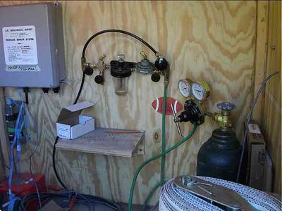
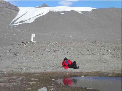
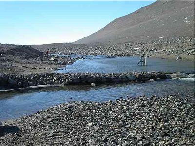
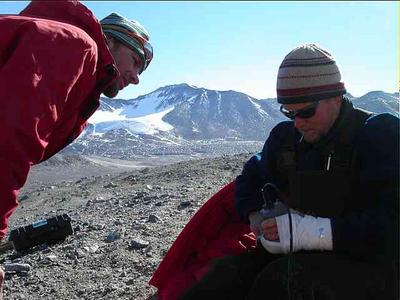
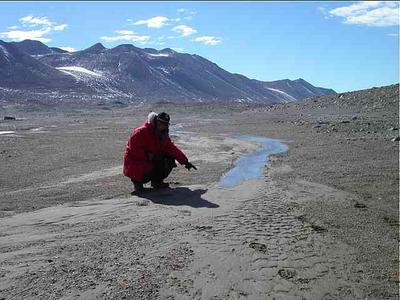
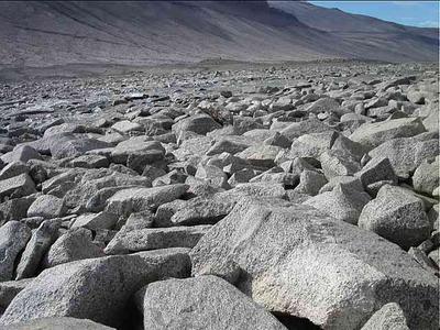
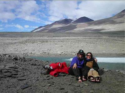
11 January, 2003Wright Valley-Wrong Team What an opportunity I had today! There was one seat available on the helicopter to tag along with the stream chemistry half of the Stream Team, and Jen and Erin let me be the one. Not only was I able to learn about the science they are doing, but I saw new areas of the Dry Valleys that "Algae Ops" will not be seeing. Thanks Jen and Erin. I owe you one! We heloed to the Commonwealth Stream in our own Taylor Valley. It is a very interesting stream because it is one of only a few that flows to the Ross Sea. The structure of the valleys is such that most of the streams flow from the glaciers into the frozen lakes. The Stream Team is measuring the discharge of the streams, which is a measure of volume (width X depth X velocity) over time. It is often reported as "cubic feet per second" and hydrologists sometimes refer to it as "Q". The team is developing graphs relating "Q" to the stage, which is the measure of the depth of the stream in relation to a known elevation. These graphs (or rating curves) help the team convert stage measurements to discharge volumes. The Stream Team has a control built at each gage box. The controls are built using sandbags and rocks. The purpose of the control is to establish a known elevation so that you can accurately measure the rise and fall of the stage. Pete measures discharge using a pygmy meter. We take the same measurements while doing our algae transects, also using a pygmy meter. Karen and I took water chemistry samples and conductivity readings. John checked the instruments in the gage box. Each stream gage box has a nitrogen bottle hooked up to a line that pumps gas into the stream at the "orifice", which is the end of the tubing. The pressure transducer in the gage box measures the pressure necessary for the nitrogen gas to be released. That measurement tells the scientists how much water is flowing above the orifice. The more pressure it takes for the nitrogen bubble to be released into the water, the more water there is in the stream. The data logger converts the pressure readings to discharge volumes and the storage module records those measurements so that they can be downloaded later. The measurements will be looked at over time and in relation to other variables such as weather and temperature. Together we took these measurements and observations at three stream locations today: Commonwealth Stream, Onyx River at Lake Brownsworth, and Onyx River at Lake Vanda. After working at Commonwealth for about an hour, the helo, an A-Star (the smaller one) picked us up in groups of threes and shuttled us over the mountains to the Wright Valley. What a spectacular view we had as we rose up over the Commonwealth Glacier. Mt. Erebus, the active volcano near McMurdo, could be seen belching smoke. (Check out a live movie of it erupting this year at http://157.132.101.72/~erebus/mevomm/movstrom.html ) Off to the east the glacier connected with the Ross Ice Shelf, looking like a huge polar plateau - miles and miles of white. As we banked west into the Wright Valley I again had that feeling of being one of only a lucky few to see this remote and beautiful place. The Onyx River stretched out in front of us, the longest river in the Dry Valleys, and the only one to be called a "river." Ken, our helo pilot, put as down at the Kiwi hut, a tiny little wooden structure with one bunk bed and a counter for cooking. In the event of an emergency it would serve nicely as a survival structure. The Onyx River has one of the oldest control structures on it, and one of the oldest records of study in the Dry Valleys. We finished all of our measures at the gage box and then took a few minutes to look around. The mountains rose up on both sides of the valley, their sides smooth and sandy until you get to the top where ragged looking ventifacts jutted out. As we were standing marveling at the beauty around us, John yelled excitedly for us to look. A stream was just beginning to flow right toward us. For the Stream Team, this was a defining moment! We all got down and watched it closely as it split into two channels and began filling up with glacial melt water. Some streams have started their seasonal flow while we have been camped in Taylor Valley. We visit the dry stream site and then a few days later it has water flowing, but none have started in front of our eyes! A 212 helo (the big ones) arrived and flew all of us to the west end of Wright Valley to the lower gage box on the Onyx River at Lake Vanda. The desert stone pavement changed to large gray stones that look like they were placed carefully as if laying a patio. John told me that the control structure at this gage has a classic "V" weir. The weir has a known volume and is rated, so when the stage is measured on the staff plate, (stick in the water that looks like a yardstick), the discharge is known. Pete still takes his own discharge reading of each stream to verify that the reading being recorded inside the gage box is correct. After taking our water samples, Karen and I took a hike past Lake Vanda and up into the hills on the north side of the valley. We took our ice grippers in case we should want to walk on the lake, but the moat is so wide now that we would have had to take a swim to get to the ice! The moat was a beautiful turquoise color and it even had some little waves breaking from shore to the ice edge. We felt like we were at the beach. We took off our boots and coats, put the ice grippers on like sandals, and had our pictures taken on the sand! The hills were brown like the mountains, but had a black stripe along the tops. We decided to explore what that black line was. The sides of the hills were covered with stones, some of which looked like broken pottery pieces of red and green, but the tops were littered with what looked like broken pieces of slate. We heard the helo before we saw it, so we knew we had to hustle back to the gage box to be picked up. Walking into the wind was a lot tougher than it had been heading out, but we made it back in the nick of time. Our helo pilot gave us a terrific ride over the mountains and down the face of Canada Glacier. What a great day! Valley. Doesn't that look like a lifeguard chair in the background? It's really a Peterson Met Box, which is gathering temperature data in the Wright Valley. We took a peek inside and found out that the lowest temperature this year was somewhere between minus 40 and 50 degrees! Make a plan, and then have a back-up. Our conductivity meter's battery compartment got jammed and the batteries were dead. We all tried to get it open, but Pete was the one that finally was successful - broken hand and all. He took a spill on the ice a few days ago and had to go to McMurdo for x-rays and a soft cast. am pointing? It was pretty exciting to be there as the water got started flowing! pavement, but the Wright Valley's stones are huge and bigger than any I have seen in the Taylor Valley.
Contact the TEA in the field at . If you cannot connect through your browser, copy the TEA's e-mail address in the "To:" line of your favorite e-mail package. |