|
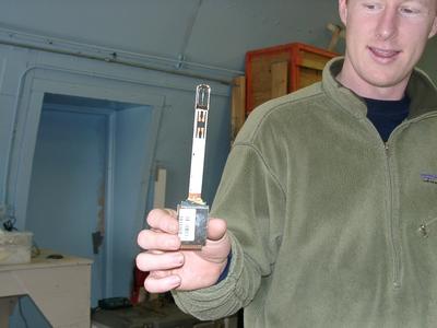
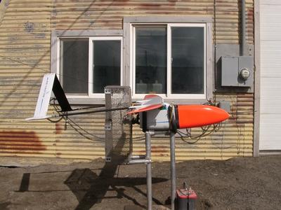
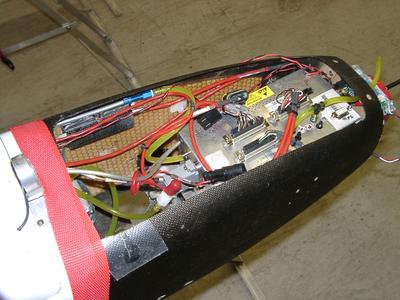
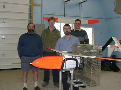
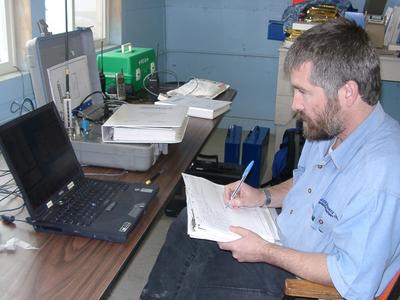
15 July, 2003Tuesday Light snow, temperature in the thirties. Cold and windy all day. In the northern Alaskan summer, “night” occurs when one gets tired and goes to sleep. “Day” is when one is awake and working. It has nothing to do with sunlight or lack thereof. July in Barrow means 24 hours of sunshine, so “night” takes on a new meaning. I was not used to seeing children riding ATVs and bicycles at 11 p.m. People were out walking and playing until 2 a.m. My brain is still on Eastern Daylight Time, and could not quite comprehend full sunshine at midnight. My room has dark curtains, so I was able to get to sleep. Aerosonde Update Three Aerosondes are on site, and two more are due to arrive sometime this week. Each aircraft is numbered and named. It is easier for me to remember the names. “Clay” will take flight on Wednesday or Thurdsay, weather permitting. The Aerosonde crew spent today in pre-flight testing and readying of the aircraft. The airplane was taken outside, strapped to a harness and allowed to run for several hours. A cable connected the Aerosonde linked to a computer terminal inside the workshop. The performance of the mechanics of the craft was easily monitored and recorded. David patiently explained to me the function of each of the multitudes of windows on the computer screen. Each window reflects a parcticular aspect of the aircraft at any given moment. He can immediately see throttle settings, rpm, yaw, pitch, cylinder head temperature, battery voltage, and a variety of performance indicators that were a bit above my comprehension. There is even an alarm system. For example, if the battery runs low or if the cylinder head overheats, an alarm on the computer sounds and David can make the appropriate changes to correct the problem. Other screens show the data in graph or chart form, and it is easy to toggle from one window to another. Flight plans may be remotely changed or updated at any time. Take offs and landings are done manually, the flight is controlled from the computer. David also records this information in a log book, and the computer constantly archives the data. The cargo area is filled with the sensing devices and the data recorder. I was surprised to find out that the GPS unit is sandwiched within the wing, and that the antennas are in the tails, and the meterological sensing devices (sondes) are attached to the underside of each wing (one per wing). The sondes consist of a wire temperature sensor, a humidity sensor, and an air pressure sensor. I found the design of the humidity sensor quite interesting. Two small y-shaped metal pieces are held with the y-parts facing each other. These prongs are coated with a special polymer that bonds with water molecules. Based on the amount of water absorbed and the air temperature, the computer software calculates the relative humidity. There is also a passive infrared pyrometer (temperature sensor) designed to measure surface temperatures. Known as a KT-11, this somewhat heavy device is accurate only to about –30 degrees F. This is a problem in that the surface ground temperature in the Arctic can get to below –30 degrees. While this type of sensor is easy to install and use, it may not be the most suitable for extreme cold weather conditions. A simple Olympus digital (“consumer”) camera is used for still shots. It is connected to the monitoring equipment via a serial port. The team would prefer a higher quality digital camera, but so far they have not been able to find one with a serial port connection – the newer models have USB ports. Instead of using the autofocus the lens is set at infinity. The crew hopes to get some good images of cloud cover and sea ice. Clay seems to have passed all the tests today; there will be more testing tomorrow before flying. More about the Aerosonde: Biological and environmental applications While week’s missions will focus on climate data collection, it is important to keep in mind the wide range of possible uses for the Aerosonde. I am parcticularly interested in biological and environmental applications. Aerosondes are now being used to monitor fisheries, agriculture, forest fires, and types of pollution. My home state, North Carolina, has some specific environmental problems that may be suitable for monitoring via Aerosondes. The number one contributor to stream and wetland degradation in NC is siltation (due to intense development). There are archived LANDSAT images of NC waterways showing degrees of siltation, but I wonder if the Aerosonde could be used to gather data in a more timely and cost-effective way. Another problem in our state is thermal pollution of waterways (due to reduction of over-canopy and depth reduction). This has a direct impact on commercial inland fisheries and the trout industry in the western part of the state. Perhaps these ideas will develop into some sort of student project for my AP Environmental Science class. Visit the Aerosonde website to learn more about this state of the art UAV. BASC Research This morning I had the opportunity to talk with Glenn Sheehan, Director of BASC (Barrow Arctic Science Consortium). BASC is headquartered at Ilisagvik College here in Barrow. BASC is an amazing research center; I had no idea what kinds of projects are going on here. Graduate students, professors, and researchers from all over the world travel to Barrow, and their projects encompass all areas of science. Even though these projects are conducted as individual investigations, one cannot help but recognize the common thread weaving them into one big tapestry – the human understanding of earth and our place upon it. Specific projects include ice/climate/weather studies, snowy owl studies, on-going bowhead whale research, tundra plant response to warming, mapping projects, carbon flux in tundra ecosystems, marine science, shorebird studies, and anthropological/social studies. Check these links for more information about snowy owl research in Barrow. The UIC (Ukpeagvik Inupiat Corporation) Science Center – goal is to illustrate the interaction between native peoples and scientists and to involve local students in science – schoolyard projects – data collection and site monitoring The Barrow Environmental Observatory is a tract of land set aside for tundra research. High school and middle school students from the area parcticipate in research projects at the BEO. Today is “Taco Tuesday”. Scientists from BASC gather informally at Pepe’s Mexican Restaurant in Barrow to socialize and talk shop. Anne Jensen, an anthropologist, was kind enough to take me. It is also “Movie-in-the-lab night”, so I will see what’s playing. Jim Maslanik from CU arrives tonight, and weather permitting we should start flying tomorrow. Sun is shining. I am tired, so it must be night time. I believe that tomorrow will be a good day for flying.
Contact the TEA in the field at . If you cannot connect through your browser, copy the TEA's e-mail address in the "To:" line of your favorite e-mail package. |


