|
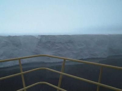
16 February, 2000The Barrier Edge February 16, 2000 215 PM (Tuesday 815 PM Maine time) 77 10 S 172 34 E Temp 13 Fahrenheit Wind 26 mph, out of the south We've gone out around Ross Island, and we're now sailing east along the edge of the Ross Ice Shelf, also known as the "barrier." What does that mean? I'll try to tell you. The ice that covers Antarctica slowly flows to the edges and out into the ocean all around. (Think of it as a big blob of applesauce, slowly spreading out from its own weight.) Sometimes, when a lot of ice is flowing into an area like a bay, where it isn't as likely to be broken up by waves and tides, the ice will flow out on to the water, floating in a big, flat layer. There's still water underneath, sometimes hundreds of miles in from the front edge of the barrier. You could go in under there with a submarine, but it would be pretty cold and dark. How thick is the ice shelf? It varies a lot, thinner in front and thicker toward land. A good average figure is about 400 feet, the spacing of two or three telephone poles along a road. Of course, only a small fraction of that thickness, one quarter or less, will be above water. Right now, the ship is idling about 100 feet from the edge of the barrier. The water below us is about a half a mile deep. We've stopped for a CTD, a measurement of how temperature and the amount of salt in sea water change with depth. I promise I'll explain more later. We're not anchored (it's much to deep), just keeping ourselves in place with our engines. Now that you've read the above, wherever you are, let me give you an idea of what it is really like here. Do this in your mind. Take what you are reading into a walk-in freezer, and take two big window fans with you. Get some dry ice, the kind that they make theatre smoke with. (If by any chance you actually do it, leave out the dry ice part. The carbon dioxide although not poisonous, will smother you.) Bring a florescent light into the freezer, one that doesn't work too well, sometimes bright and sometimes dim. Now turn on the fans and let them blow the dry ice smoke and cold air around you. Now close your eyes and picture yourself out on the bow of big red ship, moving slowly up and down with the waves, in the cold wind blowing off the ice shelf. Ahead of you, in the fog and snow is a big wall of ice, just about as tall as the ship is. From the bridge, five decks above the water, the captain can almost see up on top of the ice. Snow, ice and fog swirl off the edge of the shelf towards you. Sometimes the sky gets lighter and the sun almost comes out, but mostly it is dark and gray. The big wall in front of you disappears to the right and left, into the fog, but it is hard to tell how far away, because your eyes are constantly fooled. Your brain doesn't know distances because your eyes have nothing familiar to look at. The wall is not smooth. It looks like it has been chopped with a huge ax, because pieces are constantly falling off. There are also little bays, and at the edge of one an ice arch big enough for a trailer truck has been carved out by the sea. But, all in all, it is a straight wall, appearing on one side and disappearing on the other. While you watch two skuas fly by, and later a snow petrel. They glide, turn and bank between you and the wall, looking for food. A minute later a large section of the top edge of the wall collapses and falls into the sea, hitting the water in a huge cloud of sea smoke, which quickly blows away to leave a spreading ring of floating slush. You turn around and look off the stern of the ship, out into the fog. The water is grayish black with intensely white house-sized ice chunks floating. The wind blows wisps of mist off the water, which weave around the ice bergs and are lost in the fog. In places the sea is almost oily looking, because the water is very near freezing. You look around for as long as you can stand the cold, then go into the warm, well lit galley of the ship for a hot drink. That's what it is like right at the edge of that big white area on the map, called the Ross Ice Shelf.
Contact the TEA in the field at . If you cannot connect through your browser, copy the TEA's e-mail address in the "To:" line of your favorite e-mail package. |