|
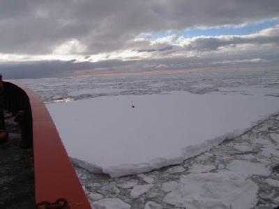
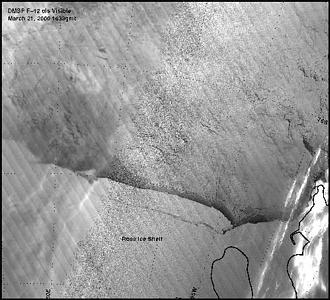
22 March, 2000Stop the Presses! Ross Ice Shelf Calves Connecticut! 71 06 s, 103 45 w Shelf break north of Thurston Island Winds SE 25 knots (29 mph) Temp 13 C (9 F), Barometer 1000 mb, steady Wind chill 34 C (-29 F) Course 031 @ 5 Knots (6 mph) Depth 603m (1978 ft) In my February 28 journal entry I talked about some of the work we had done mapping the edge of the Ross Sea Ice Shelf. As we traveled along the edge of the shelf, we used radar and the ship's GPS navigation to make an accurate chart of the northern edge of the shelf. You may remember that I gave you a hard-to-read map showing that the shelf edge had advanced northward over the last several decades. I also listed some possible reasons for the advance. I was startled to learn this morning that satellite photos show a large part of the Ross Ice Shelf, including most of the edge we mapped, breaking away and starting to drift out to sea! The new iceberg is about 275 km (170 mi.) by 40 km (25 mi.), giving it an area of 11,000 square kilometers (4,250 square miles.) In area it's slightly less than one Connecticut and about the same as two Delawares. It's about three times the maximum area of the now historical Thwaites Iceberg Tongue ("the cold tongue that isn't" in March 4 journal entry.) Not only that, but it is about three times as white as California and forty-two times as cold as Florida. By any account, it is a serious piece of ice. Scientists (including those on board the Nathaniel B. Palmer) are already considering why it broke off, how it will move, and how long it will stay in one piece. I've included a satellite visual image with this entry showing the crack forming. I've been told there is a better image at http://uwamrc.ssec.wisc.edu/amrc/iceberg.html . We will be watching its progress in satellite images day by day onboard ship, not because it poses any danger to us, but just out of interest. You might think that the work we did mapping the outer edge of the shelf has lost its value, now that the shape and position of the ice edge have changed, but that is not so. Our accurate mapping has several uses. For one thing, it gives a record for the future of one maximum northward extension. Remember that our mapping showed the position of the ice shelf edge moved outwards about one half kilometer per year, so that what broke off represents 80 to 100 years of movement (if the rate has been constant.) When the shelf next breaks off, future scientists will have data to compare theirs to. When the new iceberg floats off, research vessels will have an excellent opportunity to examine the bottom in the now open water. Because of our mapping, they will know exactly how far under the old shelf their sites were. Jesse Johnson has suggested another use for our data. He will go back and carefully calculate the annual speed and acceleration of the ice front. He wants to see if the portion of the shelf that broke off had recently accelerated its northern movement. Also in the February 28 journal I listed a number of possible reasons for the observed northward progression of the ice edge, and asked you to think about which might be correct. The first idea on the list came from Dr. Terri Hughes (whom I haven't told you about yet) who is aboard the Nathaniel B. Palmer with us. His idea was this: the shelf keeps extending northward and then once in a while a large piece breaks off and moves the ice shelf edge southwards again. That certainly seems a correct explanation for our map and the new berg. It is also possible that Terri Hughes' explanation is part of the whole picture, and that other factors such as sea level rise are acting. An interesting feature of the Ross Ice Shelf is the Bay of Whales. The Bay of Whales seems to be a permanent feature on a changing ice edge. If you look at the accompanying satellite image you will that the new crack begins in the bay, seen as a sharp indentation north of Roosevelt Island. Because the ice front is low, several expeditions have landed supplies and people there. Amundsen launched his discovery trip to the south pole from the Bay of Whales, and Byrd used the bay to establish his Little America bases. The ice front is low in the Bay of Whales because the shelf is thin there. The shelf is thin there because, as the ice flows, the Bay of Whales is downstream from Roosevelt Island. Coming from the southeast, the ice flow splits and goes around Roosevelt Island, then rejoins near the bay. This explains why, despite movement of the ice front, The Bay of Whales has been known as such since Shackleton's 1908 voyage in the Nimrod. It would be interesting to know if the fact that the ice shelf is thinner in the Bay of Whales area makes it weaker, and therefore the place where long cracks start. Maybe the present birth of Connecticut (or the Delaware twins) is just one of a series of such events, each starting with a crack at the back of the Bay of Whales. I finally got the starry night I wanted, and have taken some spare moments to go out on deck and look at the deep clear sky. A planet and the moon are setting through the orange streak in the northwestern sky. It is beautiful, but I don't stay out too long. The wind has shifted to south at 25 knots (29 mph) and the temperature has dropped to around 20 C (-4 F.) I keep thinking of the snow crocuses coming up in my front yard in Maine.
Contact the TEA in the field at . If you cannot connect through your browser, copy the TEA's e-mail address in the "To:" line of your favorite e-mail package. |