|
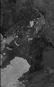
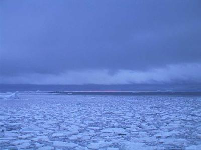
8 March, 2000Frequent Flying Picture 72 08 s, 118 55 w -5 C (23 F) Wind 24 knots (28 mph) from southeast. Barometer 981 mb, steady Depth 739 meters (2425 ft) Ship headed generally northeast, following and mapping continental shelf edge Stopping periodically for CTDs and cores I woke up this evening and outside the porthole of my cabin it was snowing heavily, big flakes of it passing by sideways in the deck lights. Outside I could barely see beyond the rail of the ship, but I could tell by the sounds of the SeaBeam pings that we were in about 600 meters of water. From the clang of ice on the sides of the ship I could tell we were in ack ice, medium sized floes of old, rotten multi year ice. Occasionally the ship would lurch to one side or another, which told me there were some bigger, more solid pieces. These push the ship around as much as the ship pushes them. I went down to the galley to midrats, to put something in my stomach, and some coffee in my head. Being a cook on a ship must be difficult. You have little space to work in, and that space is often rocking back and forth. But I'm amazed at what the Nathaniel B. Palmer's galley crew comes up with. Tonight it was Pizza, soup, pancakes, scrambled eggs, grits, or oatmeal. Not to mention fresh baked bread, cookies and doughnuts. The pizza was for people going off watch, not those just waking up. I'm a big oatmeal fan. I realize that a lot of you are not, but I'm sure you would find something here to look forward to. Feeding cold tired people in Antarctica takes lots of planning and hard work. After another cup of coffee I went up to the bridge to look around and find out what was happening. The view from the bridge was like the view from a car travelling in a snowstorm at night. The bright spotlights lit up snow, and the visibility was only a hundred meters. The radar and the SeaBeam could see much further though. The first looked miles ahead through the snow, and the second looked a half mile below at the bottom. Tom Kellogg was on the bridge, watching the SeaBeam output paint a picture of the shelf break as we went along. We talked for while about what he was learning on the cruise, and the questions he was trying to answer. Scientists on board seem always willing to discuss science, which I don't mind doing at all. Speaking of seeing, let me show you a picture of a part of Antarctica taken from space. One picture with this journal looks like a black and white photo, but it is really a radar image of the Thwaites Glacial Tongue and the eastern part of the Bear Peninsula, taken by a Canadian Space Agency satellite called Radarsat, an active microwave satellite. The picture you are getting on your computer screen is just a degraded shadow of the original. If you've ever photocopied a picture, then photocopied the copy, and copied that copy, then you know what I mean. If you enlarge this image on your screen, you will quickly see individual pixels, or squares. The original image had very high resolution, and had the 94 meter (308 foot) Nathaniel B. Palmer been in the area, it would have been detectable, and you might have been able to pick out the lifeboats. This image has been a long way in getting to your screen. The satellite scanned the area, stored up the information, and perhaps sent it to earth as it passed over Canada. The Canadians then sent a copy to Dr. Shusun Li aboard the ship, via another satellite. They sent a slightly lower resolution copy, because the original would have taken a long, expensive time to send. I copied the image, and degraded it further, so I could send it back over a third satellite, to Denver. From Denver it goes out on the Internet to you. If pictures could get frequent flyer miles, this one could fly for free. Take a look at the image. It may help you to print this description and have the image in front of you. The center of the picture is at about 74 degrees, 15 minutes south, 107 degrees, 0 minutes west. North is in the upper right corner and south in the lower left. The biggest thing in the picture is the Thwaites Glacier tongue (not the same as the now gone Thwaites Iceberg Tongue) in the lower left. It is about 56 km (34.5 miles) across. Halfway up the left hand edge of the picture you can see the eastern part of the Bear Peninsula. The glacier tongue is floating, and is some hundred or more meters thick. Notice the bay between the glacial tongue and Bear Peninsula. From that bay extending almost to the upper right corner of the picture you will see an area slightly lighter in shade than its surroundings. This is the "fast ice" area I was talking about in a recent journal entry. It is located where the Thwaites Iceberg Tongue used to be. There is also an area of fast ice along the right hand portion of the bottom of the image. Notice that embedded in that fast ice area are a number of icebergs, large and small. They look like little white chips. There are more icebergs here than anywhere else in the picture. The largest one, in the upper central portion of the image, reminds me of Indiana. I confess I don't remember the exact shape of Indiana, but I think it looks like that iceberg. This berg is about fifteen kilometers (9.3 miles) square, and is just to the left or west of the fast ice area. Two other long thin bergs, maybe fifteen kilometers long, are embedded in the fast ice between Indiana and the bay. Many of these icebergs are probably grounded, although we cannot be sure. In the area where the fast ice is we don't know the depth. Even a stronger ice breaker than the NBP would have difficulty getting through the fast ice. I know some icebergs touch bottom, because when ping editing I can see the places on the bottom where current or wind driven bergs have plowed the bottom sediment in long grooves. The rest of the ocean shown in the images is relatively dark. Some of this may be open water, some new ice, some pancake ice, and some floes. You can see pack ice along the upper right edge of the picture, to the right of Indiana. Sometimes it's hard to tell open water from new ice, and rough water from pack ice. Looking at visual images helps interpret radar images, if there are no clouds to block the scenery. Remember that microwave satellites can see through clouds and at night. The work being done aboard the Nathaniel B. Palmer by the "ice people" will help make interpreting these microwave pictures easier and more accurate. Just to the right (east) of Bear peninsula, in the left central portion of the picture, there is a large, slightly darker berg the shape of a stubbed out cigarette. North of it is a darker area, which could be new ice or maybe open water. It looks like the berg has moved south through the ice or the ice moved north past the berg. The second choice is correct. The eastern (left) half of the bay isn't really fast ice, it is heavy pack. You can see a faint dividing line between fast and pack. The pack ice has blown northward past the grounded cigarette butt, leaving a "shadow" behind it. A picture is worth a thousand words. You've gotten the thousand words and the picture! An update: I still haven't gotten the word on penguin's knees, but I did find the missing sock.
Contact the TEA in the field at . If you cannot connect through your browser, copy the TEA's e-mail address in the "To:" line of your favorite e-mail package. |