|
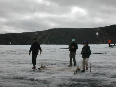
16 July, 2001One of the components of this project has been to collaborate with the ice radar team from St. Olaf College. Ice radar is a technique that is used to remotely image surfaces that are beneath the top of the glacier. Most often, ice radar is used to characterize the bedrock surface on which the glacier is situated. For this project, the ice radar is being used to characterize features within the ice. Specifically, the intention is for the ice radar to image englacial conduits. Dr. Bob Jacobel a Physics professor from St. Olaf. He has two undergraduates with him, Robert Engles and Peter Pearson. Ice radar works on a relatively simple principle. An electromagnetic wave is transmitted from an antenna. This wave will propagate in all directions into air, along the surface of the ice, and into the body of the ice. As the wave encounters objects in its path, it will be scattered and reflected. Situated nearby the transmission antenna is a receiving antenna. Reflected waves will be absorbed by this antenna. If the travel time between the transmission of the wave and the reception of the wave can be measured, then the distance to the reflecting surface can be calculated (of course, the velocity of the wave in ice must also be known). The frequency of the electromagnetic wave that is used depends on the size of the intended object to be imaged. To seethe bed topography the wave needs to pass through hundreds of meters of ice. So, the wavelength needs to be on the order of hundreds of meters (frequency and wavelength for an electromagnetic wave are mutually, and inversely, dependant parameters. This means that the wavelength will be determined by the frequency that is used). In this case, the ice radar will be used to image objects that are on the order of centimeters and meters. So, that is what the magnitude of the wavelength will be. Because the desired transmission wavelength will be shorter than what is typically used to see the bed, then a higher frequency wave will need to be used. Dr. Jacobel has been using 50 MHz and 100 MHz antennas for his work. It is a relatively new application. So, one of the goals of this project has been for the ice radar team to image features in the ice that look like englacial conduits, and then advise us on where to drill. And, we (the drillers) have been looking for conduits, and will advise the ice radar team where to look for features that look like conduits. So far, the approach seems to be working. The borehole video camera is picking up drainage features (conduits), and subsequent radar imaging has shown them to be present. The radar team has also been working in a different part of the glacier and has advised us on where to drill next. So, we will be moving the drill in the next few days to a new part of the glacier. The ice radar team collects its data directly onto a laptop computer. When it is raining, they cannot do field work. So, they have been out for only a few days so far. However, in those few days they have collected a lot of data.
Contact the TEA in the field at . If you cannot connect through your browser, copy the TEA's e-mail address in the "To:" line of your favorite e-mail package. |