|
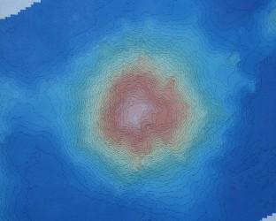
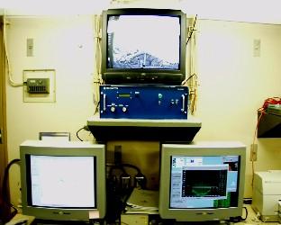
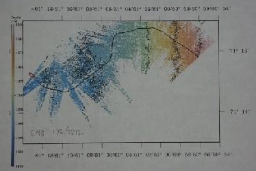
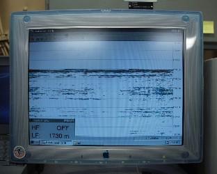
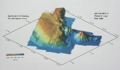
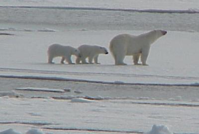
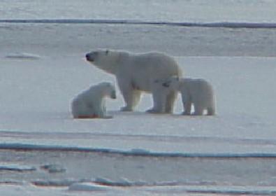
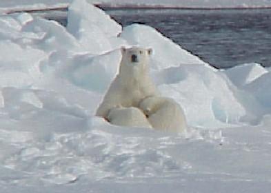
20 June, 200020 June 2000 Finding Bears and Finding Bottom Finding things at sea can often be a challenge. Today I’m going to focus on finding two different things - polar bears and characteristics of the ocean bottom. Let’s focus of the fuzzy one first. Polar bears (Ursus maritimus) are marine mammals that spend most, if not all, their time on and around sea ice. They have a thick layer of fat that helps to insulate them from the cold air and water of their home environment. Their translucent hair almost makes them look light yellow against the white of the ice. Seeing a polar bear in the wild has long been a dream of mine (right up there with narwhals). Yesterday that dream came true. In the afternoon we caught a glimpse of a bear out on the ice edge as we were steaming north at 16 knots. It quickly disappeared into the distance behind us, but I had seen my first actual bear after seeing hundreds of tracks last week. The fun wasn’t over though - last night we had an even better look. As we headed back through the ice looking for places to do coring and dredging, we spotted two bears about 500 meters away, right in front of the ship. Then we saw another bear trotting in their direction. It turns out the first ones we saw were the cubs of the next one we saw. The mother had been hunting and had kept the cubs out of the way. Evidence of her hunting ability was evident in the carcass of a seal near where she was first spotted. The ship slowed and came to a stop and everyone got a nice long look at the bear family. Cameras fired away as the bears’ images were recorded by a host of crew and scientists. As the ship slowly pulled away, the mother leaned back and let her cubs feed on her milk. Like all mammals, polar bear young are nourished by their mother’s milk until they are old enough to eat “regular” food. Even the whales and seals we see here in the arctic feed the young milk for a time. Most of these marine mammals have very high levels of fat in their milk so the young can grow rapidly and maintain the insulation they so desperately need to keep warm in their cold, cold home. One thing to remember about polar bears is that they are found in the arctic only. Polar bears are NOT FOUND IN ANTARCTICA. You will never see a polar bear with penguins except in cartoons. If polar bears did live in Antarctica, they would probably gobble up all the penguins when they came to land to breed! Enough about one of my pet peeves, now, back to "How to find a polar bear". First, spend lots of time looking out over the ice for things that kind of look like blocks of ice, but are a little bit yellow, and move (not as easy to distinguish as you might think!). Second, get lucky!! The first improves your chances of the second. Finding bears on USCGC Healy is fairly low tech. We aren’t looking for bears using radio collars or infrared sensors, just binoculars and lots of pairs of human eyes. Trying to find out about the sea floor surface on USCGC Healy is a different story, where a collection of high tech tools helps ship’s personnel and researchers identify the characteristics of the ocean bottom. Two of the most important tools we are using to determine where to dredge and core are the SEABEAM system and the Knudsen Deepwater Echo Sounder. Both these systems use sound pulses to gather information about what lies below the ship. The data they generate however is very different. SEABEAM maps a wide band of the ocean floor as the ship passes over, and as this is done continuously, you end up with a map of the contours of the ocean floor you have just traveled over. This will give you an idea of what the sea floor looks like from a bird’s eye view, very much like a topographic map for land (see pictures below for a better idea). The “Knudsen” as it is referred to shows the bottom, not in a wide view, but in a linear profile. You might wonder what good a straight line is when SEABEAM gives a nice wide map. What the Knudsen gives you is not just the surface of the sea floor, but the subsurface as well. What this means, is that researchers can get an idea of not only the top layer of the ocean floor, but layers below the surface as well. Why is that important? If a scientist wants to dredge for solid rock, they want to know if the top layer is rock or sediments, like mud. If they wish to do a core from the ship, they want to make sure they have enough sediment depth for the core they wish to use for collecting data. Otherwise, they will crunch the core when it plows into solid rock. Last night while we were cruising though the ice at 71 N latitude, Dr. Larry Lawver, of the University of Texas at Austin, was monitoring the SEABEAM and Knudsen looking for a sea bottom that had a steep slope (SEABEAM info) and was also solid rock (Knudsen info). As we moved into the ice, he found a steep slope, but it was covered with sediments and would not do for the dredging. Plans were changed because we then found plenty of relatively flat spaces with deep layers of sediment that should be suitable for the coring testing. This morning has been used to get set up for coring off the starboard side while we are here in the ice. This is one of the main tests they wish to accomplish on this leg of the cruise and dredging will wait until we find a suitable place. I will follow up with coring information in my next journal. So, tomorrow you’ll meet some of the people and high tech processes involved in finding the story held in the sediments at the bottom of the sea, and while we are in the ice, I’ll keep using the low tech methods to try and find some more bears. Note: A big thank you to LT MacDonald for the use of his polar bear pictures from his digital camera last night. I was using my 35mm camera with a telephoto lens, and will have to wait until July to see how mine came out.
Contact the TEA in the field at . If you cannot connect through your browser, copy the TEA's e-mail address in the "To:" line of your favorite e-mail package. |