|
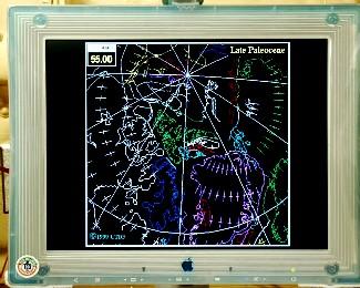
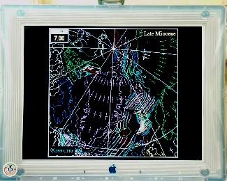
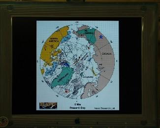
23 June, 200023 June 2000 Our Puzzling Planet Plate tectonocist you ask? That was the term I finished yesterday’s journal with, describing Dr. Larry Lawver of the University of Texas at Austin’s Institute for Geophysics. Dr. Lawver studies plate tectonics, the movement of the earth’s crustal plates. Many students are at least somewhat familiar with this process, but for those of you that aren’t, here is a somewhat brief introduction. The earth’s crust is a relatively thin layer of solid rock that essentially floats on the molten mantle below it. This rocky layer is made up of a collection of interconnecting plates of varying sizes. Movement of the magma in the mantle causes the plates to move, and where plates meet, one of several things can happen. The process that generates much of the movement occurs where plates spread apart due to new magma pushing its way to the surface and pushing the plates out as it forms new crust. This most often takes place underwater where the crust is thin and results in mid-ocean ridges and rift valleys at locations known as sea-floor spreading zones. This process continues to spread South America and Africa apart. Closer to where we are, the same process keeps increasing the distance between Greenland and Scandinavia. Nearby Iceland is one of the few places where a spreading zone goes through land. When plates are pushed together, either one plate will be pushed under the other or they will be piled up against each other. If one plate is pushed under another plate, known as subduction, the oceanic crust sinking into the mantle takes water with it lowering the melting point of the granite above it. This new magma often comes up as volcanoes. This process formed the volcanoes of the Cascade Range, such as Mt. Rainier in Washington, Mt. Hood in Oregon and Mt. Shasta in California. If both plates are under water when subduction occurs, the resulting volcanoes often form an island arc such as the Aleutian Islands of Alaska. If the plates pile up, large mountain ranges such as the Himalayas are formed. Plates may also slide along each other where their edges meet. These areas are known as transform boundaries and are characterized by abundant earthquakes. These slipping and sliding zones can often be identified by the presence of large fault lines. The San Andreas fault is a good example of this feature. As you should begin to see, the surface of our planet is like a dynamic jigsaw puzzle, where the pieces are not just constantly moving around, but also changing in size. As these pieces move, the landmasses that jut out of the ocean on top of them are moved around with them. The movement of these landmasses is known as continental drift. Most middle school or high school earth science classes deal with the big pieces of the puzzle. The links between major masses, especially South America and Africa, are quite evident. It is all the little pieces of the puzzle that researchers are still trying to piece together and trace to their past locations during our planet’s history. This is what Dr. Lawver spends his time studying. Evidence of past movements can be found in the rocks of the continents themselves, but direction and rate of movement can most readily be found in the rocks created during sea floor spreading. As the magma from these zones cool, their magnetic direction is set. You may not be aware of it, but the magnetic pole of our planet flip-flops episodically and this magnetic change is reflected in igneous rocks. These changes in direction are called magnetic anomalies. By looking at these anomalies around spreading zones, researchers can see when the rock was formed and determine how fast various zones were spreading. This lets someone like Dr. Lawver backtrack the position of continents over time. Todd and I were able to see several simulations Larry and his associates have put together that show the movement some of the pieces over time. It is fascinating to see all the pieces move and change - a virtual geologic ballet, and to see the origins of what we may see today as a single piece of land. Among the most interesting areas to see for me, was the construction of the state of Alaska from hundreds of bits of continental crust. One thing Dr. Lawver pointed out on his animations was where there were not any magnetic anomalies evident. One location where this occurs is in the Gulf of California where he did his doctoral research, and another is Baffin Bay where we are now. These areas both show evidence of spreading, but their spreading zones are buried under so much sediment that the new magma just forms a layer underneath the sediments as it solidifies. This is because the sediments insulate the magma, slowing its cooling, compared to when it comes up directly into the water at the bottom of the ocean. When the next layer is formed, it cools above the previous layer, and so on, and so on, until you have a layer cake of igneous rock under the sediments. The magnetic story is then trapped under the upper-most layer rather than spreading out from the diverging boundary. This is where Larry uses information contained in the cores discussed in the past couple journals to deduce where the spreading zones are, and how fast they might be spreading. He accomplishes this by sticking needle-like probes into the cores to measure thermal conductivity with depth and he measures the thermal gradient through the core with a different type of probe. Thermal Gradient and Thermal Conductivity are multiplied to calculate heat flow, which relates to how long ago the sediments were heated by magma below them. This information helps fill in some of the missing puzzle pieces left by the magnetic anomaly data. All of it together allows a geophysicist/plate tectonocist/master-puzzle-solver like Dr. Lawver begin to piece together our earth’s geologic history and possibly predict some of its future.
Contact the TEA in the field at . If you cannot connect through your browser, copy the TEA's e-mail address in the "To:" line of your favorite e-mail package. |