25 June, 2000
June 25, 2000
I am sitting at the Portland airport waiting to depart for Anchorage. The
flight has been delayed by two hours, so I have some waiting to do. It is
early evening here and I will likely watch the sun set on Portland before I
board the plane. I am already anticipating the twilight that will greet us
when we arrive in Anchorage at about 1:00 AM.
I was fortunate to be able to parcticipate for a second year on this project.
This project involves studying an outburst flood. An outburst flood occurs
when a large volume of water is suddenly released from beneath a glacier.
Often times unexpected, outburst floods can present a hazard to those
situated downstream of the glacier outlet. Outburst floods also present an
opportunity to study how water behaves as it melts in and around a glacier,
permeates and glacier, and flows around, on, through, and beneath a glacier.
So, this project is really about glacial hydrology, and its response to a
catastrophic hazard.
The outburst flood we are studying is a regular occurrence - it happens once
every summer, sometime between early-July and mid-August. The glacier from
which the flood emanates is the Kennicott Glacier, which originates high in
the Wrangell Mountain Range, and terminates near McCarthy, Alaska. The
source of water for the flood is from Hidden Creek Lake, which backs up a
side valley (Hidden Creek Valley) behind the main stem of the Kennicott
Glacier. The relatively large Kennicott Glacier acts as a dam through which
the water from Hidden Creek Lake cannot flow. The location of Hidden Creek
Lake is 12 miles up the Kennicott Valley from the terminus of the glacier. At
some point during the summer, the water from the lake makes its way to a
subglacial drainage system, through which the lake drains catastrophically.
This same water makes its way to the terminus of the glacier and emerges as a
substantial volume of water.
The questions of this study involve trying to measure how much water is
released to the Kennicott River during the flood, how much water is drained
from Hidden Creek Lake, what the response of the Kennicott Glacier is to the
filling and draining of the lake, and what kind of drainage network develops
beneath the glacier.
A team from the University of California at Santa Cruz will study the
discharge of the Kennicott River before, during, and after the flood. Dr.
Suzanne Anderson will be in charge of this part of the study, which will be
based at the terminus of the glacier in McCarthy. The rest of us will be
spending our time 12 miles up the glacier at three different locations.
Two people will study the physical parameters of the lake before, during and
after the flood. These two people are U.S. Geological Survey scientist Joe
Walder and Portland State University (PSU) grad student Michelle Cunico.
They will camp in the lake basin, isolated from the rest of the glacier team,
which will be camped on the ice.
Dennis Trabant, from the U.S. Geological Survey in Faribanks will be
surveying markers located on the ice dam to precisely measure the changing
position of the surface of the glacier adjacent to the lake. He will be
located on a bluff overlooking the glacier and the lake. He will also camp
at his post, and will do so by himself.
The remainder of the "glacier team" will be camped on the ice near the
drilling operation. Andrew Malm, and undergraduate physics major from St.
Olaf College will use ice radar to determine the thickness of the glacier.
University of Washington seismologist Steve Malone will set out an array of
seismometers to carefully monitor the internal motions of the ice. PSU
glaciologist Andrew Fountain, PSU grad student Don Lindsay and myself will be
doing the work drilling and studying the boreholes that will be put into the
ice to the bed of the glacier. These boreholes will be the primary means in
understanding how the water passes from the lake and into/beneath the glacier.
This is the second year for this project. We hope to expand the data set
significantly over what was collected last year. Last year was considered a
success, but the lake drained much earlier than expected. As a result, there
are a number of hypotheses and unanswered questions that still need to be
addressed. Hopefully some of them will be figured out this summer. However,
as is usually the case with most scientific studies, they end with more
questions than answers.

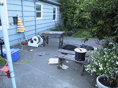
Prepping the borehole video camera cable for its eventual use in the field. A total of 400 meters (1300 feet) of cable is included on two different spools. Yellow tape was attached and labeled at 1-meter intervals so that the viewing depth at a given borehole will be known.

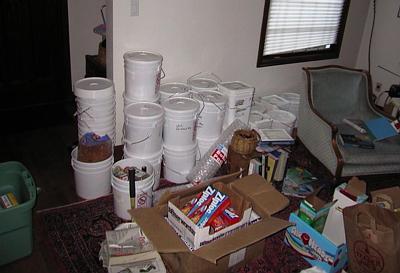
Packing the food - I took on the responsibility of planning, purchasing, and packing all of the food for seven people to survive a month on a glacier. Most of it has been packed into the round white buckets and is ready to be shipped.

Contact the TEA in the field at
.
If you cannot connect through your browser, copy the
TEA's e-mail address in the "To:" line of
your favorite e-mail package.
|
