|
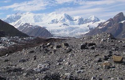
12 July, 2000July 12, 2000 Surveyor Dennis Trabant has renamed Hidden Creek Lake. He now refers to it as Lake Won't Be Gone. It is still on the rise, and hasn't slowed (2 feet per day). We (PSU grad student Don Lindsay, PI Andrew Fountain, and myself) drilled another hole today. We easily got to 235 meters before we hit something relatively soft. It felt like some type of sediment at the bottom of the hole. Based on Andrew Malm's (St. Olaf undergraduate) ice radar results, we are uncertain about where the bottom of the glacier is located. Yesterday he got a signal that corresponded to 1200 meters, which is very deep. Today the weather was too wet for his equipment - a dense fog descended on us for much of the day. Hopefully we will find out tomorrow how thick the ice is at this location. In the meantime, we will soldier on and start a third hole at this general vicinity tomorrow. Drilling………………there is a reason why what is left is called a borehole. Making one is a bore. Once the drill tip begins to melt its way through the ice it descends at about 40 to 60 meters an hour. The person at the drill usually keeps their hands around the descending hose, feeling for the banging around of stones, or the occasional bounce of the drill tip on the bottom of the hole. This person needs to make sure that the drill tip does not stop on the bottom. So, throughout the course of 200 meters of drilling, this person usually spends many hours sitting at the deepening borehole, feeling the hose, making sure that it is still progressing downward. This is the interesting job. A second person needs to keep an eye on the various machines that make the drilling happen. Specifically, this person needs to make sure that the pump that sends the water to the drill does not exceed a certain pressure. This person sits and stares at a pressure gauge on the pump for hours on end, and reports to the person at the drill if the pressure is running too high. Drilling becomes interesting when the water level changes in the borehole (this means that the borehole has made a connection with an englacial conduit feature), or if there is a malfunction in the equipment (then we get stand around and give our various opinions as to what is wrong - Don Lindsay is usually right). This aspect of science is ordinary. It has lots of tedious moments. It often encounters glitches. Tenacity and creative solutions to unforeseen problems are the hallmark of a successful field season. Analysis of data and development of theory are the icing that comes only after long and arduous hours of hard, and at times frustrating work.

Contact the TEA in the field at . If you cannot connect through your browser, copy the TEA's e-mail address in the "To:" line of your favorite e-mail package. |