|
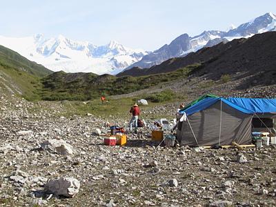
13 July, 1999July 13 We were flown by helicopter into the study area today. St. Olaf undergraduate student Andrew Malm and myself were flown first to a proposed camp. From there we off-loaded the camping equipment as it was shuttled in on sling loads. Joe Walder and PSU grad student Michelle Cunico were dropped off at the lake where they unloaded a sling load of equipment that would be used for their part of the study. PI Andrew Fountain and driller Joel Harper were placed on the glacier to find a drilling site where they would unload drilling equipment. PSU grad student Don Lindsay prepared the sling loads for the helicopter at the staging area located 12 miles down the valley. He was later flown onto the ice to the drill site. I spent the day at our intended camp site, home for the next few weeks, organizing piles of gear and equipment. It is a beautiful spot. Mt. Blackburn looms to the north. A huge ice fall cascades from its flank - the Kennicott Glacier. The terrain on the glacier is difficult to move around in. PI Andrew Fountain, driller Joel Harper, and PSU grad student Don Lindsay had to hike out from where they were off-loading equipment on the ice. It took three hours for them to get off the glacier and back to camp. Crevasses, seracs, moulins, and small glacier ponds are abundant in the area of the drilling equipment. So, now that everyone is getting equipment into the respective study areas, I will review and explain what will be done with all of this gear. The objective of this study is to measure an outburst flood. This phenomenon, in which stored water beneath a glacier is catastrophically released from the base of the glacier, was first observed and studied in Iceland. The Icelandic term for the subglacial release of water in this manner is Jokulhaup. In our study, there is a lake (Hidden Creek Lake) which backs up behind the margin of a glacier (the Kennicott Glacier). The surface of the lake rises as it receives meltwater during the summer. At some point, the lake drains catastrophically (relatively rapidly) beneath the glacier, flows down the valley for twelve miles, where it comes out at the snout of the glacier near the town of McCarthy. No one has ever measured a glacial outburst flood from source to discharge before. Two people will be responsible for placing pressure transducers along the bottom of the lake. These will measure changes in hydrostatic pressure which will give an indication of the changes in water level of the lake. These two people will be Joe Walder, one of the Prinicipal Investigators (PI) and Michelle Cunico, a graduate student from Portland State University (PSU). The change in the surface elevation of the glacier near the lake (called the ice dam) will also be measured. It is assumed that the lake "floats" the adjacent glacier prior to the drain/flood. These data will be gathered by using Global Positioning System equipment (GPS) and total stations surveying equipment. Dennis Trabant, a U.S. Geological Survey scientist from Fairbanks, will be responsible for this aspect of the study. The purpose of the drilling equipment is to drill holes through the ice to the bed of the glacier and tap the hydraulic system beneath the glacier. These holes need to be positioned on the ice dam as close to the lake as possible. These holes will be made by a hot water drill operated by Joel Harper. Joel is a post-doctoral fellow from the University of Wyoming, the owner of the drill system. Pressure transducers will be placed into these holes to measure the changes in water level, and acquire real-time information about the hydraulic pressure beneath the glacier. It will be parcticularly interesting to get this information for hydraulic conditions before, during, and after the drain/flood. These hydraulic pressure data will be gathered by PI Andrew Fountain and PSU grad student Don Lindsay. Prior to drilling, the depth to the bed of the glacier will be determined by using ice radar. This aspect of the study will be performed by Andrew Malm, an undergraduate student from St. Olaf College. A borehole camera, which was set up by myself, will be lowered into the hole to look for features which might affect the pressure measurements. The discharge stream of the glacier at the snout will be measured before, during, and after the flood by a team from UC Santa Cruz. These people are undergrad student Christy Swindling, grad student Erin Kraal, and geomorphologist Bob Anderson. Finally, seismometers will be placed on the glacier to measure the "bumps and wiggles" of the glacier before, during, and after the flood. This work will be done by University of Washington seismologist Steve Malone. I will take over his work when he leaves the study site later this week. If everything goes according to plan, the glacier and lake will be "hard-wired" to gather a diverse suite of information to scientifically document this unique natural phenomenon - a Jokulhaup. Everyone is anxious to get started. _______________________________________________________________ Get Free Email and Do More On The Web. Visit http://www.msn.com
Contact the TEA in the field at . If you cannot connect through your browser, copy the TEA's e-mail address in the "To:" line of your favorite e-mail package. |