|
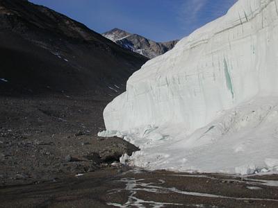
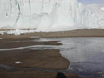
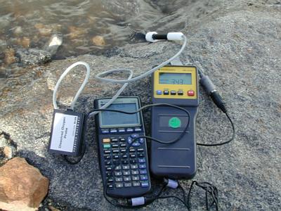
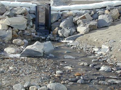
8 December, 1999Lake Hoare and Anderson Creek - Schoolyard LTER site I spent several days documenting with digital photos Anderson Creek that runs into Lake Hoare in the Taylor Valley, Transantarctic Mountains and site of the McMurdo Dry Valley LTER. It is December 8th, 1999. Measurements on temperature, dissolved oxygen, pH and flow depth (only at the weir) were taken at several places on Anderson Creek using Vernier probes, a Calculator Based Lab data collection instrument and a Texas Instrument TI-83 calculator. The temperature of the water flowing just past the weir is 0.19°C, the pH is 7.2 and the dissolved oxygen is more than 100%. There was no primary productivity when measured using the protocol on the http://TEA.rice.edu web site in the activities section. The water depth is .38 (units are USGA feet in 100th increments) and the water is flowing at a rapid rate over riffles and under ice bridges. THe flow rate os calculated to be o.3 cubic meters per second. The measurements were taken at 9:25 p.m. with the sun shining from the west onto the West Side of the ice face. From 4:30 p.m. until 6:45 p.m., the sun moves behind the Asgard Mountain range. I can hear water flowing louder than that which I can see. There are no macro-invertebrates in the stream and very little movement of the gravel in the streambed by the water flow at this time. The water is crystal clear. While there may be some bacteria in the water, I have no way to measure them or try making a culture. If I were to try to grow any bacteria that I might find, first how would I find them? Second, how would I go about culturing them? What variables do I need to consider? There are no macro-invertebrates in the stream, but there are some micro-invertebrates along the edges of the lake frozen into the ice. There is a microbial mat along the edges in some places on Lake Hoare near where Anderson Creek flows into Lake Hoare in which one can find all kinds of algae, protozoa, nematoda, tardigrades and rotifers. The rotifers are bright red. Within the mat one can see algae such as nostoc, oscilatoria, some kinds of paramecia and other small fast swimming protozoa. The schoolyard LTER is a partnership between the McMurdo Dry Valleys Long Term Ecological Research site, Lakeside School's Thornton Creek watershed study and the Tuscaloosa Academy's watershed study on the creek running along the border of their school. Each of the three sites makes the same measurements and posts those measurements on water quality on the web at the following location:http://www.wgs.lyonsden.ua.edu/-schoolyardLTER. Students doing a watershed study as part of their science coursework are encouraged to compare their data with that posted on the schoolyard web site. As a student, you should think about what factors influence the data you collect. In what biome is your watershed? This watershed in the Taylor Valley of Antarctica is considered a polar dessert biome. In the Anderson Creek watershed, the high latitude is definitely a factor influencing the data. Continued low temperatures and the unusual light -dark cycle also strongly influence this ecosystem found in the Taylor Valley in Southern Victorialand, Antarctica. Anderson creek flows along the West side of the Canada Glacier and into Lake Hoare. The water flows under the ice cover on the lake at the mouth of the creek. There is a broad delta of fine parcticle sand with many small rivulets flowing into the lake. On November 24th, I visited Anderson Stream and Lake Hoare. At that time there was no liquid water flowing in the creek. The creek bed was filled with ice at the upper ranges and the sandy delta at the mouth of the stream was dry. There was no melt water around the shoreline of Lake Hoare. While it was partly sunny that day, the temperature was slightly below O°C and no liquid water was present on the surface of the lake or in Anderson Creek. Look over the pictures that span the creek's short distance of about a mile in length. Compare it with the creek in your area. What are the similarities? There are probably lots of differences. The top of the food chain here is the rotifer and tardigrade. . Lake Hoare and Anderson Creek - Schoolyard LTER site I spent several days documenting with digital photos Anderson Creek that runs into Lake Hoare in the Taylor Valley, Transantarctic Mountains and site of the McMurdo Dry Valley LTER. It is December 8th, 1999. Measurements on temperature, dissolved oxygen, pH and flow depth (only at the weir) were taken at several places on Anderson Creek using Vernier probes, a Calculator Based Lab data collection instrument and a Texas Instrument TI-83 calculator. The temperature of the water flowing just past the weir is 0.19°C, the pH is 7.2 and the dissolved oxygen is more than 100%. There was no primary productivity when measured using the protocol on the http://TEA.rice.edu web site in the activities section. The water depth is .38 (units are USGA feet in 100th increments) and the water is flowing at a rapid rate over riffles and under ice bridges. The measurements were taken at 9:25 p.m. with the sun shining from the west onto the West Side of the ice face. From 4:30 p.m. until 6:45 p.m., the sun moves behind the Asgard Mountain range. I can hear water flowing louder than that which I can see. There are no macro-invertebrates in the stream and very little movement of the gravel in the streambed by the water flow at this time. The water is crystal clear. While there may be some bacteria in the water, I have no way to measure them or try making a culture. If I were to try to grow any bacteria that I might find, first how would I find them? Second, how would I go about culturing them? What variables do I need to consider? There are no macro-invertebrates in the stream, but there are some micro-invertebrates along the edges of the lake frozen into the ice. There is a microbial mat along the edges in some places on Lake Hoare near where Anderson Creek flows into Lake Hoare in which one can find all kinds of algae, protozoa, nematoda, tardigrades and rotifers. The rotifers are bright red. Within the mat one can see algae such as nostoc, oscilatoria, some kinds of paramecia and other small fast swimming protozoa. The schoolyard LTER is a partnership between the McMurdo Dry Valleys Long Term Ecological Research site, Lakeside School's Thornton Creek watershed study and the Tuscaloosa Academy's watershed study on the creek running along the border of their school. Each of the three sites makes the same measurements and posts those measurements on water quality on the web at the following location: www.wgs.lyonsden.ua.edu/-schoolyardLTER. Students doing a watershed study as part of their science coursework are encouraged to compare their data with that posted on the schoolyard web site. As a student, you should think about what factors influence the data you collect. In what biome is your watershed? This watershed in the Taylor Valley of Antarctica is considered a polar dessert biome. In the Anderson Creek watershed, the high latitude is definitely a factor influencing the data. Continued low temperatures and the unusual light -dark cycle also strongly influence this ecosystem found in the Taylor Valley in Southern Victorialand, Antarctica. Anderson creek flows along the West side of the Canada Glacier and into Lake Hoare. The water flows under the ice cover on the lake at the mouth of the creek. There is a broad delta of fine parcticle sand with many small rivulets flowing into the lake. On November 24th, I visited Anderson Stream and Lake Hoare. At that time there was no liquid water flowing in the creek. The creek bed was filled with ice at the upper ranges and the sandy delta at the mouth of the stream was dry. There was no melt water around the shoreline of Lake Hoare. While it was partly sunny that day, the temperature was slightly below O°C and no liquid water was present on the surface of the lake or in Anderson Creek. Look over the pictures that span the creek's short distance of about a mile in length. Compare it with the creek in your area. What are the similarities? There are probably lots of differences. The top of the food chain here is the rotifer and tardigrade. .
Contact the TEA in the field at . If you cannot connect through your browser, copy the TEA's e-mail address in the "To:" line of your favorite e-mail package. |