
|
|
15 November, 2002
Island Wood Sun Path at Greenhouse
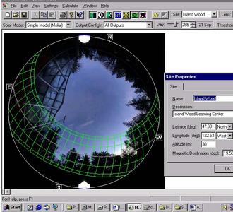
ISLAND WOOD SUN PATH AT GREENHOUSE Island Wood is an environmental learning center visited by upper elementary school classes in the Puget SOund area. This photo was taken with the fisheye lens near their greenhouse. The camera was placed near the greenhouse and a photo is taken loking straight up.You can see land all around the sky and trees. The grid lines on top of the photo represent the solar path during the year. The lines top and bottom represent June and December. Which line represents the sun during both November and January? The lines show where the land will receive direct sunlight. The box at the right gives longitude and latitude. Why did I need this data? To account for the tilt of the earth, we include the declination number. What is the declination for Island Wood? Is this a good place to build a greenhouse? What do you think?
Contact the TEA in the field at
.
If you cannot connect through your browser, copy the
TEA's e-mail address in the "To:" line of
your favorite e-mail package.
|


