
|
|
7 November, 2002

Antarctic Sun Path Imposed Over Lincolnville, Maine Photo If you looked at the photo from yesterday and understand the grid lines imposed on the photo, then this will be fun. Now you see the solar path from Lake Fryxell in the Taylor Valley of the Transantarctic mountains where we will be taking our samples of soil imposed on the photo. How different is the sun path? As we move into December, how many hours of direct sun will we be getting compared with Lincolnville?
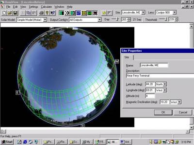
Lincolnville, ME Actual Sunpath. This fisheye photo taken in Lincolnville near Vinelhaven High School in Maine shows the solar path by month for an entire year. The lowest arc line is the sun path in December. The next line up represents the sun path during January and November. DO you know why it is the same for November and January? The top arc line is the sun path in June. Using this grid, one can determine the amount on direct sun an area will receive. The box at the right contains important information needed to calculate the sun path. Why are these pieces of information needed?
Contact the TEA in the field at
.
If you cannot connect through your browser, copy the
TEA's e-mail address in the "To:" line of
your favorite e-mail package.
|


