
|
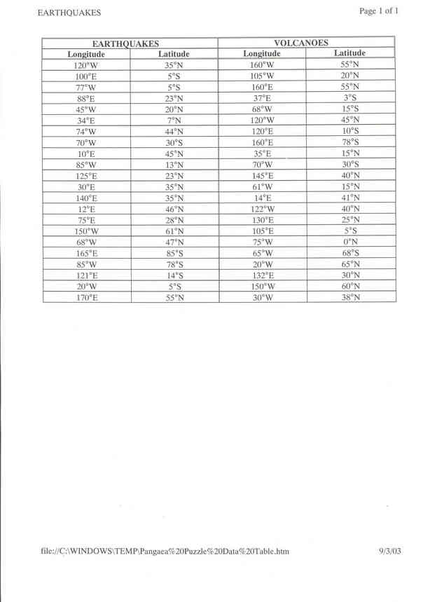
Pangaea Puzzle data | hook | main | background & resources | student Miriam Sutton, 8th Grade Science Newport Middle School 500 E. Chatham Street Newport, NC 28570 (252)223-3482 msutton@nms.carteret.k12.nc.us www.carteretcountyschools.org/nms/classwebs/msutton * The information in this laboratory investigation was modified from an original version (Locating Patterns of Earthquake and Volcano Distribution) published by Prentice-Hall, Inc. Additional maps and information were obtained for education use only from National Geographic and USGS. Overview Grade Level/Discipline National Standards Pangaea Puzzle also meets the following North Carolina Standard Course of Study Science Objectives: 3.02 - Evaluate evolutionary theories and processes: geological; technological. 3.03 - Examine evidence that the movement of continents has had significant global impact: major geologic events. 3.04 - Evaluate the forces that shape the lithosphere: constructive; destructive; earthquakes. 3.05 - Analyze information from technology used to monitor Earth from space. 4.07 - Apply Newton's Laws of Motion to the way the world works: acceleration; action/reaction; force; mass. Pre-activity set-up Complete the Data Collection section of the activity, plotting earthquakes and volcanoes as indicated by the data set (latitude and longitude coordinates). Create a transparency of your completed Earthquake/Volcano Map to use as a display in Day 2: Data Analysis and Application Materials Internet access Computer software: word processing, spreadsheet, PowerPoint Reproduced copies of these handouts:
Time Frame Engagement and Exploration (Student Inquiry Activity) 1. Introduce the lesson with a brainstorming session to generate responses to these questions: a. What observations could scientists from the 19th and early 20th century make to help them determine that the earth had a single landmass (Pangaea) which has broken into several pieces throughout geologic time? b. What types of data could they collect to support their hypotheses? c. How could earthquake and volcano data from around the world assist scientists with theories such as Continental Drift and Plate Tectonics? 2. Assign students to a cooperative learning team with 4 or 5 students in each team. 3. Distribute a copy of the IBA materials to each student. (See Appendix A in the Student Section) a. Review the IBA Problem and Procedures with the students and answer any questions concerning the longitude and latitude coordinates that will be used in this lab. b. Facilitate student completion of the IBA procedures. Students unable to complete the assignment during the remainder of class should finish plotting the coordinates for homework. Explanation (Discussing) 1. Review the following concepts from the previous class discussion: a. What is the worldwide pattern of earthquake and volcano distribution and how can scientists use this data to make inferences about changes in the earth throughout geologic time? b. How have technological advances (e.g., GPS, satellite imagery) changed data collection methods for geologists? 2. Encourage team members to check each other's maps for accurate earthquake and volcano plots. Corrections should be made if needed. Display a transparency of the correct plots to assist students who may have difficulty with the corrections. 3. Display a list of the following land and sea formations in the classroom: a. Aleutian Islands b. Andes Mountains c. Great African Rift Valley d. Himalayan Mountains e. Marianas Trench f. Mid-Atlantic Ridge g. San Andreas Fault 4. Provide an opportunity for teams to select one of these land/sea formations for their investigation. Selections can be awarded on a first-come basis, or other appropriate strategy for the variety of choices. Teams should not duplicate selections. 5. Display the Lab Rubric in the classroom and distribute one copy to each team. (See Appendix B and C in the Evaluation Section) Review the contents and expectations of the rubric with the students and provide clarification as needed. 6. Students may work independently or in teams to complete the Lab Rubric. Facilitate student/team completion by coaching each team through the investigation of their selected land/sea formation. 7. Students should have the following assignments completed at the end of the lesson (Homework is assigned accordingly): a. Land/Sea Formation selection b. Hypothesis through the Procedures of the Lab Rubric c. An outline of the research methods each team member completed for DAY TWO (using the Internet resources noted) d. An outline of the research methods each team member needs to complete for DAY THREE. DAY THREE: DATA ANALYSIS to CONCLUSION 1. Review the plate boundary concepts of this IBA by displaying the website:http://neic.usgs.gov/neis/plate_tectonics/majplatecolor.pdf a. Divergent boundary b. Convergent boundary c. Transform or Strike-slip boundary 2. Review the Conclusion section of the Lab Rubric and provide clarification as needed. 3. Students may continue to work independently or in teams. Facilitate completion by coaching each team through the appropriate tectonic forces that created their land/sea formation. Encourage self-exploration using the Internet resources and provide open-ended prompts as needed to insure that each team is locating appropriate and accurate information. 4. Once the each team member has completed the Lab Rubric, they should construct a schematic for the Power Point presentation. This schematic should be approved by the teacher prior to any PPT computer work by the team. 5. Students should have the following assignments completed at the end of today's lesson (Homework is assigned accordingly): a. Data Analysis through the Conclusion of the Lab Rubric b. An outline of organized notes from the research record for their land/sea formation c. A schematic drawing of the team's PPT presentation, including images and concepts to be covered DAY FOUR: POWERPOINT CONSTRUCTION {COMPUTER LAB} 1. Provide each team with 2 computer stations and monitor their progress in relation to the PowerPoint Presentation Rubric to insure accurate and informative PPT presentations of their land/sea formation. Teams should have a completed a 10-minute PPT presentation or an outline for their team's Homework Assignment. 2. Teams should be encouraged to practice their presentation and monitor individual parcticipation, organization, and timing during their PPT presentation.
Elaboration (Polar Applications) a.http://csep10.phys.utk.edu/astr161/lect/earth/tectonics.html b.http://www.enchantedlearning.com/subjects/astronomy/planets/earth/Continents.shtml Exchange (Students Draw Conclusions) 1. Determine the order of presentation for the teams and provide an adequate amount of time for each team to organize their PPT files and supplemental materials (if applicable) prior to their presentation. 2. Use the PPT Rubric to record the team scores based on the objectives met during their PPT presentation. Encourage the audience to record notes about the information each team presents pertaining to their land/sea formation and determine the similarities and/or differences between the land/sea formations explored by each team. 3. At the completion of each PPT presentation, the audience is encouraged to ask questions pertaining to information that may have been omitted or presented incorrectly. Any corrections made by the presenting team during this question/answer audience session should be recorded as objectives met on the Lab Rubric. Teams with remaining errors or omissions after this Q&A session should be prompted or coached by the teacher for the information. If the information is provided by the team, a minor point deduction is recorded for each objective prompted. Teams who are unable to successfully complete the objective may lose five points to an audience member who can successfully complete the objective. (This latter strategy highly motivates audience attentiveness and parcticipation.) 4. Conduct an open forum after all teams have completed the PPT presentations. Focus the discussion on the following: a. Types of plate boundaries (described with examples) b. Types of plate collisions (described with examples) c. Movement in major verses minor plates d. Newton Laws of Motion relative to Plate Tectonics e. Sea-floor spreading (including magnetic and rock evidence) f. Convection currents
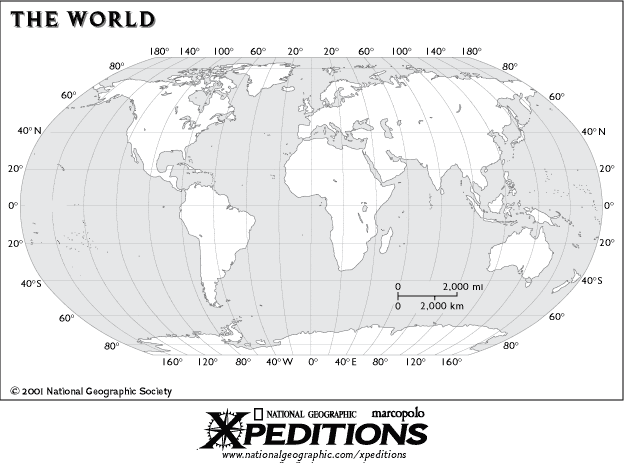
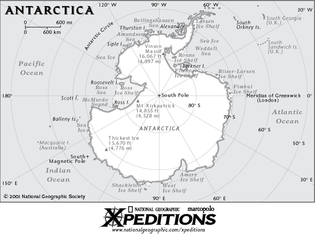
Evaluation (Assessing Student Performance) Hypothesis: Write complete sentences clearly stating the purpose of this investigation and also noting the landform your team chose to explore and determine the formation of during Earth's geologic time. (5 points) Materials/Resources: Write a complete sentence describing the materials and resources needed to complete the investigation. (2 points) Procedures: Write a paragraph describing in detail the procedures that were followed to successfully complete the objectives for this investigation. Be sure to be very specific so that others can repeat your procedures and achieve similar results. (10 points) Data Collection: Data should be illustrated on a world map, showing the correct distribution of volcanoes and earthquakes. Be sure to follow procedures carefully to ensure that a difference is apparent between the volcanoes and earthquakes plotted. Plate boundary regions should be highlighted on your world map based on the team's cross-reference with the Plate Tectonics map displayed in class. (10 points) Data Analysis: Describe the relationship observed between the location of earthquakes and the location of volcanoes using your data (Ex., far from each other, near each other, etc.) (8 points) Describe the geographic locations (e.g., oceans, countries) where earthquakes and volcanoes occur. Include the countries, continents, bodies of water identified during the class discussion. (4 points for each region identified, up to 32 points) Conclusion: Identify the plate boundary and lithospheric plates located near your team's selected landform and describe the characteristics associated with this type of plate boundary. (10 points) Identify the type of plate collision occurring between the plates identified near your team's selected landform and describe the characteristics associated with this type of collision. (10 points) Explain how the information obtained in this lab can be useful to scientist when making inferences about current and ancient changes in the Earth and in species over time. (5 points) Explain how this type of data can be useful to people living on Earth. (5 points) (Headers, footers, and an appropriate font provide 3 points.) APPENDIX C: PowerPoint Presentation Rubric (Verbal Component) (This rubric provides an example for scoring the written component of this activity. A sample of possible points awarded for each segment are also provided. This rubric should be modified to meet individual class needs and learning levels.) (This activity may be completed in a team and presented to class as an oral presentation.) The following is a list of sample objectives each team member should understand and be able to answer during the oral presentation of your lab: 1. How do the theories of Continental Drift and Plate Tectonics relate to the findings in your lab? (10 points) 2. Which lithospheric plates were identified during your lab? Locate these plates on your map and be able to name them. (20 points) 3. What plate boundaries were identified in your lab? Locate these on your map and be able to explain actions and reactions that occur at these types of boundaries. (25 points) 4. Which plate collisions were identified in your lab? Locate examples of these types of collisions and be able to explain the actions and reactions that occur as a result of these types of collisions. (25 points) 5. How do your findings relate to Newtonˇ¦s Laws of Motion? (10 points) 6. What inferences can be made based on your teamˇ¦s research about ancient landforms, such as the Appalachian Mountains or the Trans-Antarctic Mountains which currently show no plate boundary markings? (10 points) data | hook | main | background & resources | student |