|
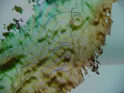
10 August, 2001August 10, 2001 How Do We Know What's Down Below? We have been sailing aboard the USCGC Healy for almost 2 weeks now, and on our journey we have been making maps of the ocean floor. The maps, made using a system called Seabeam, are what the lead scientists constantly look at to make the decisions as to where we will dredge and do the wax coring. The maps clearly show the topography of the ocean floor, and the scientists can distinguish the features (such as volcanoes) that they want to collect samples from. They then relay their plans to the bridge (where the navigation occurs), and the captain gets us to our destination. Remember that this area of the world has virtually been unexplored. We are charting new territory as we make maps. Statistics: Latitude: 84 23 N Longitude: 0 38 E Air temp: 38 F Water temp: 29 F
Contact the TEA in the field at . If you cannot connect through your browser, copy the TEA's e-mail address in the "To:" line of your favorite e-mail package. |