|
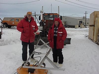
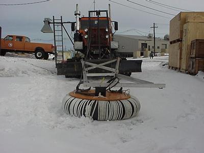
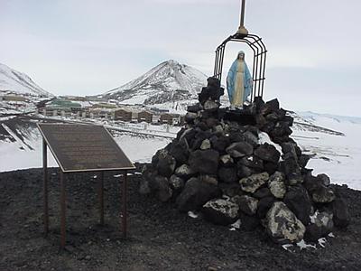
14 November, 1999Sunday November 14, 1999 Woke Up about 0500 hours and went to the Crary lab where I worked on the computer until 1230 hours. I was rested and Barb and I had nothing planned, so it seemed like a good time to work on journals. Seven and half-hours at a compute are a long time. Decided to take advantage of a great day so went to dorm, put on ECW and took off for Derelict Junction (a meeting place in McTown) where I was going to take the shuttle to Scott base to visit the KIWI camp, but missed it. No problem I'll walk around McTown. As I was walking pass the machine shop I came across a Tuker, a tracked vehicle, that was being outfitted for the ITASE (International Trans Antarctic Science Expedition). This expedition will travel from Byrd Surface Camp (BSC) Antarctica for a distance of some 150-km onto the West Antarctic Ice Sheet. It will return back to BSC for resupply and then trek about 200km to Upstream C. The researchers will be taking core samples and using radar to study the stratigraphy along the entire route. The part of the project that I am most familiar with is that headed up by PI Dr. Steve Arcone with his peer and former mentee Dr. Bert Yankielun. These two men are from CRREL (Cold Region Research and Engineering Laboratory) in Hanover NH. They plan, as part of the group, to traverse the West Antarctic Ice Sheet (WAIS) using Tuckers and Ski mobile. This specially designed and specially outfitted Tucker, has four radars on board. Two will be used on the way out and two will be used on the way back. As I understand it, one set gives more detail, the other greater depth. One of the radar is a short-pulse radar with 400-MHz antenna. This should provide a vertical resolution (tens of centimeter) and penetration to a depth of about 60 meters. The radar on the front is mounted on an old plane tire inner tube, so that it will bounce over the ice surface. Another of its task will be to scan the forward path for crevasses. The other radar will provide information about the different layers of snow and ice. Along the paths of this traverse the researchers will take, in addition to the radar data, snow samples, kinematic GPS (Global Positioning System) data, they will do snow pit studies, surface geological studies and at 100 kilometer intervals will take core samples to a depth of 200 meters. The ultimate goal of all these data collection are to give an understanding of the last 200 years or so of the changes that have occurred in the climate and environment of the West Antarctic Ice Sheet. The ITASE project is multidisciplinary and includes studies of: the glaciochemistry, the microstructure and transport properties of snow and firn, the accumulation of environmental byproducts (hydrogen peroxide, formaldehyde and nitric acid). ITASE will study the mass balance and accumulation rate of ice along the route of the traverse and it will study the distribution of the isotope O18 (the ratio of this to O16 can give indication of past climactic conditions). I stayed with Bert and Steve until they took the Tucker to the sea ice. I had been invited to walk along side but I could not go because have not had my training in that area as of yet. I decided to walk up Arrival Heights. This is a mountainous area to the left of McTown (as you enter from the sea ice) immediately above Hut Point where Scott's 1902 expedition hut is located. At the top of little hill was a shrine and commemorative plague honoring a sailor lost on the sea ice. I climbed and climbed to what I thought was the top, but as the song about "the bear went over the mountain" says saw another mountain", and proceeded to climb. I climbed for about an hour and a half and finally got high enough so that I could see some of Mt. Erebus. I guess Mt. Erebus is directly north of McTown.What a view! There was one other person up where I was, and he passed me as he headed for yet another higher mountaintop. It was real interesting to use my binoculars and find a research camp (Jamesway and an outhouse) located what had to be miles up on the glacier that come down the southeastern face of Mt. Erebus. I was getting cold so returned to my dorm. I went over to the Crary lab to attend the Sunday night science lecture and got so busy working that I did not realize it must be being held at another location. I looked at my watch and saw it was 2030 hours and it should have already been started. It was in fact at a different place; but, if is any conciliation there were four others working at the computers and waiting to hear the lecture. I'm too tired . Good night. Penguin Pete the Polar Man
Contact the TEA in the field at . If you cannot connect through your browser, copy the TEA's e-mail address in the "To:" line of your favorite e-mail package. |