|
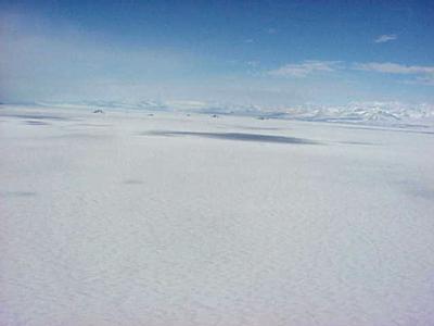
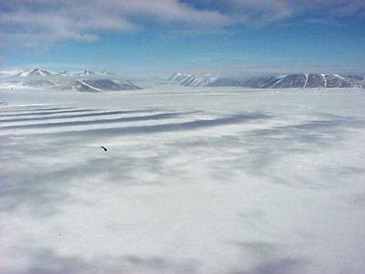
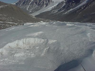
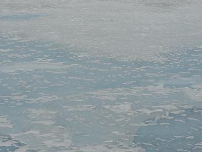
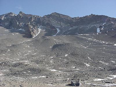
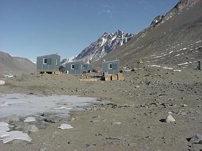
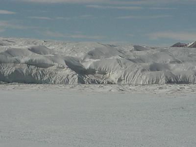
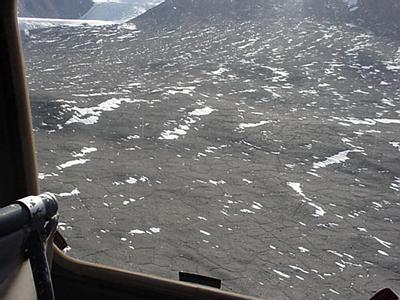
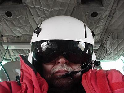
24 November, 1999Wednesday November 24, 1999 I got up at 0530 hours to the sound of the tank construction crew returning from work, These are the guys who are building new fuel storage tanks just to the west of Observation Hill. I have to get al my ECW gear together, plus my photography, stuff, plus my journal, plus my water bottle. Our sleep kits, tents and survival bags should already be at the helicopter pad. I have much to do before meeting with Kathy and Barbara at 9000 hours for our 1000-hour launch. More later. We arrived at the helicopter pad at 0930 hours each of us was weighed with all our ECW gear, water bottles, pea bottles and camera. Then each of our drag bags was weighed and marked as well. Must know total mass that will fly because it cannot exceed the mass that the helicopter can carry. We were then issued helmets. When the helicopter final arrived the helo-tech instructed us to wait on the flight line while she loaded tee helicopter. The pilot, Barry James from Texas, stopped by on his way to get a drink to say hello. Seems like a real mellow guy, unlike the hard nosed-nasty disposition pilots that are described by everybody else. As we boarded the helicopter we were told when the fire extinguisher was; where the emergency locator beacon was (and to use the antenna from the hand-held radio if we had to move away from the helicopter after it touched down. We were also given the called #s for helo-ops as well as McOps (Ops = operations). You could hear the pilot through the helmet go through his check-list then it was "Helicoper-13 Quebec, launch for Lake Hoare" The whole scene of being in a helicopter; being in the copilots seat (I was offered this and took it. I didn't fall off of the cabbage dog-sledge yesterday you know.) and actually looking like one, helmet on with sun-visor down. I wasn't just playing, anyone in the helicopter must dress as I described. The thought of being flown to work to the Dry Valley is more then my tiny little mind can comprehend or explain. Remember there probably hasn't been 100,000 -120,000 people since the beginning of time who has been to the dry valley. We swung out over the sea ice toward the runway then head almost dead center up the Ross Ice Shelf toward the open ocean , some 50+ miles away. I guess this would be pretty much in a west by northwest direction, but believe me if you have trouble figuring out directions at home this place is a nightmare; since to sun goes in circles overhead Remember there are no sunrise and sunsets at least until February.) The view from Heo-13Q was awe inspiring as we flew at an altitude of 1000' feet above the frozen mass of McMurdo Sound with an OGS (over ground speed) of about 110 MPH. The weather was crystal clear and the sky as blue as could be. Radio traffic head in the helmet, was also very exciting as you could hear all transmissions among all aircraft and aircraft operations in the area. Wow almost like a dream. I don't know how, but as we flew further up along the coast the scenery got more beautiful by the mile. Out the starboard side of the helo we passed Hut Point, Arrival Heights, Mt. Erebus, Big and Little Razorbacks and finally Cape Evans. As we went up the Sound further we stayed, I guess, on what would be on west side of the Sound and the mountains are terrain on the starboard side stayed beautiful but appeared to shrink do to the broadening distance. Out of the port side of the helo we passed White Island, Mt. Aurora, Mt. Discovery, Black Island , Brown Peninsula,(all points visible from MC Town and part of the Royal Society Mountain Range). We proceeded up the Sound past Mt. Kempe, Mt. Huggins, Mt. Rcuicker, Salient and Lister Mountains where the Salmen Glacier swung down to the shore. Next there was a series of "small" (everything is relative) islands, the Daily's Islands, that were in the Sound, but immediately behind them was the tongue of the Hobb Glacier. This swept down out of the mountains, parcticularly from behind an around Hobb's Peak. Coming off the right side of Hobb's Peak is Blue Glacier and then there was this rather massive expanse of bluish-white snow and ice cover that seemed to stretch for miles along the coast and even further inland. This turned out to be the Ferrar Glacier and it sits between the end of the Royal Society Range and the Kukri Range. This glacier appears to be probably 30+ miles long and about five miles wide. (For you people in my home town area that's a swath of ice and snow that is several 100s meters thick and it stretches from Holliston to Framingham [wide] and from Framingham to Boston [long]). In the distance, in an up glacier direction, there was visible what was described as Knob Head, a 2400 meter tall mountain, the general accumulation area for the Ferrar Glacier. As we flew past the Ferrar Glacier tongue and beyond the Kukri Range there appeared an enormous valley that had a considerably smaller amount of ice and snow. This turned out to be Taylor Valley one of several Dry Valleys, part of that 2% of Antarctica where there is little or no ice or snow (relatively speaking of course). We banked left and started to descend and fly up valley. As we got lower to the deck (pilot talk for ground, you know!) You could see at the ice edge numerous icebergs. The pilot said many of these had been grounded (stuck on the bottom) here for several years. From the higher elevation they appeared as just continuations of the glaciers. Wow! The left hand side of the valley, the Kukri Range, showed up like a desert with different shades of brown. The right hand side was about half brown and half bleu-white, this being the Canada Glacier that worked its way down the side of the beginning of the Asgard Range, the mountain range making up the right hand side of Taylor Valley. I would guess about 1/4 of the right side of the valley floor was glacier, behind it you could see more brown and then at the back end of the valley you could see at least two other glaciers streaming down to the valley floor. We flew down, in and behind the Canada Glacier and landed in a down valley direction, where it opened up to a panorama of mountain walls, covered with brown and dark brown rock and sand with the head of the Canada Glacier directly in front. We landed probably a 1/8 of a mile from the glacier wall. Now heading down Valley what we saw was the following: The Kukri Range with its brown almost sand-like appearance was on the right. To my left, and we landed on what I would have to describe as the farthest left side of the valley, was the beginning of the Asgard Range, these mountains soared almost straight up. To my back was the rest of Taylor Valley that twisted and turned so that you could not see behind the next bend. The Taylor Valley I would estimate is 20 miles long by about 2-3 miles wide. Behind me, where the valley turned off to the left, there was a huge mountain (Mt. JJ Thompson), going down valley there was the Mattherhorn Glacier, next there was the Matterhorn, a 1882-meter high mountain that looks like its namesake back in Switzerland, going down valley beyond that the Suess Glacier dumped into the valley. Just to the right Helo-13Q was Lake Hoarse camp. The camp consisted of a cook /community house, three lab buildings, a Jamesway , two storage "buildings", two rocket toilets and one outhouse and several tents the homes for the field party working at Lake Hoare. The rest of the bottom of the valley, stretching back evidently to almost the Suess Glacier, was the perennially frozen lake called Lake Hoare. This lake gets its source from the glacial melt. Parts of the lake are frozen to the bottom and other parts are so deep they have yet to freeze all the way to the bottom. I am told there are 30 meters of ice in some places, that still have liquid below it for it doesn't freeze all the way to the bottom. The ice on the lake is a crystal blue color. In some places it is as smooth as glass, in some places the beautiful blue ice is sculpted by the wind and in other places the ice is a mess; owing to debris in the glacial melt water. This debris absorbs, basically because of its darker color, more heat which cause differential melting which creates these cavities. Some of these are beautiful, but others look rather disgusting due to the sandy glacial deposits. We disembarked from the helicopter and met by the camp manager Ray Spain. There were two other people, a mechanic who was dropped off earlier in the day to repair some type of engine problem and a cook. It seems that all of the field teams in the area, within I guess eight miles, are planning to walk to Lake Hoare tomorrow to celebrate Thanksgiving in the field with their friends. Unfortunately, Ray could not cook for all 34 people, so ASA flew out a galley cook to help her. When we walked in, pies had already been baked and two huge turkeys were just starting to brown in the oven. The place smelt like Heaven. Unfortunately we will have to wait until Saturday for our turkey, that is unless of course, bad weather settles in and we get grounded. The weather is too perfect so that isn't going to happen. Oh well, better luck next time. Ray decided that even though we were there only for the day now, she would discuss camp rules for when we returned for a longer stay two weeks from now. Camp Chores to Be Shared By Everyone 1. Collect glacial berries for drinking water. (These are pieces of the glacier that fall off, calve, and are melted for drinking.) 2. Melt water. There is a pot on the stove with a spicket. Glacial debris sinks to the bottom and the drinking water is drawn off. 3. Fill water coolers 4. Empty trash 5. Empty gray water (Wash/dish water) 6. Empty outhouse bag (when bag is half full of solid wastes it must be put into proper barrel.) 7. Replace toilet paper General Camp Outline 1. Keep an individual pea bottle, label it, name it, and take it with you to the field. DO NOT pea anywhere but in the bottle. DO NOT SPIT on the GROUND. 2. Leave rock in funnel in Urine-Barrel. 3. When rocket toilet is half full hang flag and let camp manager know. (Evidently a certain percentage of human waste is incinerated at the camp-site.) 4. Use personal drinking mug (Infection is a major concern.) 5. CONSERVE WATER (Lots of ice but it takes 540 Calories of heat to melt 1 gram of ice into 1 gram of water at 0oC.) 6. Keep personal stuff in tent. 7. Secure anything that is outside 8. Always carry a radio and sign out on white board when you leave camp. 9. Shower once a week (Solar bag absorbs heat to "warm" water.) 10. If you use the last of something put it on the reorder list 11. Camp is quiet after 2200 hours 12. An evening meal is served between 1700 and 1900 hours. Other meals you are on your own. Help yourself to anything, just clean up after yourself. 13. Know where the survival cache is. After our briefing Barb and I took a radio, signed out on the white board and began to meander around the valley. The immenseness of the place is beyond belief and extremely deceiving. We walked for over an hour and the place that we thought we would get to really didn't appear to have gotten any closer. Wow! We returned to camp with about an hour to spare. Barb wanted to collect some mat samples. Mat is a collection of greenish looking gunk from the ice. There are algae in it and Barb says several zoological specimens including tertagrades, rotifers and nematodes. I'll have to see this in the lab tomorrow. It is so exciting. Barb was like a kid in a candy store, remember she has worked in the dry valley before. The helicopter came right on time. This one was much bigger, I think it could hold10 not five like the last one. As we left I could see back up valley. This is probably a good time to describe the arrangement in the Taylor Valley as I understand it. The upper end of the Valley, some 20 miles inland from the coast, is fed by the massive Taylor Glacier. In this valley there are several lakes. About seven or so miles up valley from Lake Hoare is Lake Bonnie, a lake with two separate lobes. Further down valley are a couple of smaller ponds, Mummy and Chad; then there is a jog in the valley where the Suess Glacier empties, there is more barren ground and then there is Lake Hoare right at the head of the Canada Glacier. As the helicopter headed out toward the Ross Sea (down valley) we could see the full breadth of the Canada glacier field and the ice-falls where it came down out of the mountain. Mind boggling. Next as we flew through the valley there were miles of patterned ground, it looked like the hard pan that you see in dried up river bed. It was totally barren. Soon we came upon another lake, this one much bigger the Hoare, this was Lake Fryxell. We stopped there to pick up a passenger. Once airborne again, we flew down valley for a shot distance and then off to the left (I'd tell you the real direction, but by this time all I could honestly recognize was up and down.) We began to climb and now more individual mountaintops stood out. As best I can recall we pasted Mt. Falconer, Mt. Coleman (862 M) and Mt. Hjorth (759m) on our way to the cost. Interspersed among these mountains was another huge glacier, the Commonwealth Glacier. The chatter in the helmet earphones made it clear that we were headed to Marble Point. Marble Point is a rocky spit of land farther up McMurdo Sound approaching the Rose Sea that serves as a refueling and emergency landing sight for the helicopter fleet. Great more of a chance to suck up the beauty and magnificence of this place. As we flew another very tall peak, someone said Mt. Newall came into view, if that is indeed the case, then immediately beyond that would be Wright Valley another of the dry valley system. It is in this valley where yet another amazing perennially frozen lake, Lake Vanda, is being studied. The approach to the coast became gradually more flat and a massive glacier, that had to be several miles wide and I would guess scores of miles long (the Wilson Piedmont Glacier) came into view. Just beyond the face of this glacier lay Marble Point. We landed and had about 30 minutes to walk around. I opted to walk about 10 minutes up hill to a high point where I could see the still frozen Ross Sea. As I looked to my left I could see, off in the distance a dark blue line. This was the ice edge, that junction where the sea ice and the open ocean merge. Within the next two weeks that ice edge should move so far up McMurdo Sound that the ice runway will have to be abandoned. We picked up another passenger and we were off. The pilot radio ahead and said Helo -8 Hotel would be arriving in about 35 minutes with 5 souls aboard. I had noticed that phrase (souls aboard) had been used by the other pilot on the flight out. I guess I just didn't want to believe I had heard him correctly. The term soul had a bit of a scary connotation to me. Our flight back was uneventful. I was in a middle seat so could not see too much. 1500 feet below the sea ice pasted rapidly by, interrupted only occasionally by a seal, or a pod of seals either resting or lumbering across the ice pack. They looked so small from where we were, but some of them in all likelihood weighed more than a ton each. The mysticism just continues to grow and grow. Wow!!! We touched down in McTown at 1830 hours. I was tire and took a ride to my dorm. A quick trip to a special place, one without my bottle named "Fred P.P.", then to the galley for I was starving. All that truly fresh air has made me hungry; and exhausted. Awesome! I returned to my dorm and crashed. Good night. Penguin Pete the Polar Man
Contact the TEA in the field at . If you cannot connect through your browser, copy the TEA's e-mail address in the "To:" line of your favorite e-mail package. |