|
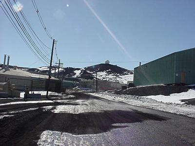
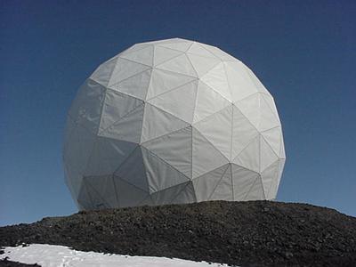
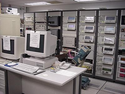
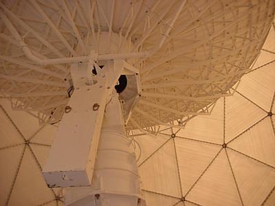
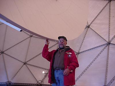
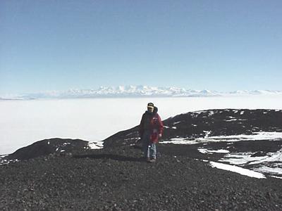
4 December, 1999Saturday December 4, 1999 Woke up at 0830 hours and would have slept longer, but tank personnel were still partying from last night. I tried to do my laundry, I need it for next week I am in the field, but the best I could do was wash it and then lay it around my room to dry. It will dry because the humidity is so very very low, but it would have been nice to be able to use the drier. I got dressed and went to the supply building where each field party's supplies are locked up in individual rooms. I went to our "cage" and could not get the lock open. As I was fumbling with it and checking the combinations this guy comes up and wants to know why was I am trying to get into his supplies. I said I was not and I gave him my Science Event # BM-042L. He was not impressed and gave me his, which matched the one written in small print on the door. What is going on? I found this fellow working there and told him what had happened, he took my event # and looked it up. Check this out. I was in the wrong building. I guess I am not the brightest light in the chandelier. Oh well, some times one must look like what one is. A fool. Having now found our stuff I gathered up materials for the field including a backpack, crampons and a pea bottle. All the other supplies, tents and sleep kits, etc. are already at Lake Hoare. I then brought these over to the lab and got them weighed. I packed some stuff for Kathy, but she said she had the rest. I spent the rest of the hour answering email. About 1000 hours Barb and I met to debrief from our project. She left about noon and I typed until 1415 hours. I then went to my room and gathered my camera for I had scheduled a tour of the NASA 10-meter satellite antenna facility for Barb and I at 1400 hours. We went to their office where we were greeted by Erik Richards a sub contractor for NASA who I had met on one of the trips to Cape Evans. NASA has their own truck so we drove up to one of the tallest hills in town, about 130 feet above the town to the Ray Dome (more commonly called the "golf ball"). This plastic and aluminum (I think) sphere that house the 10-meter antenna and is about 40 feet in diameter. Erik gave us a tour of the facility. As I said, the antenna has a 10-meter wide dish and it monitors typically six different international satellites. These satellites are all in polar orbits, basically north to south. The path they take starts and end at the same place over a 16-day period of time, but the orbits are designed so that the satellite is in the sunlight 98% of the time. These satellites have relatively low orbits, 700 kilometers, and they download lots and lots of data. Some of the slower data download is immediately sent out electronically (4 kilobits/second). But the most rapid datafeed, 105 megabits/second, is downloaded onto magnetic tape then the tapes are mailed to the various "customers" around the world. It is done this way because the computer lines cannot carry the data that rapidly. Inside the Ray Dome was this antenna. It looked just like any satellite dish only a tad larger, how about the height of a four story building. Erik made a phone call and then advised us to stand back. About 20 second later a horn, similar to the sound made when they signal a submarine to dive, echoed throughout the dome and the dish was lowered so we could see in side. It was amazing. Erik explained the electronics to us but it was way over my head. He also pointed out that the dome, a collection of plastic panels with what appeared to be aluminum supports, was designed to withstand 150-mph winds. He also pointed that unfortunately, just before they finished building it, they had 200 MPH and the whole thing was destroyed. "Murphy" at work again. Before we left the site I gather snow for the young man in Mississippi that needed me to be his lab assistant. Upon returning to McMurdo I put on my wind pants and grabbed some gloves and went walking off to the ice runway, a little more then 3 miles from my dorm. The walk was gorgeous and there were people cross-country skiing and riding bicycle down the ice runway. This is truly an amazing place. It took me a little over an hour to walk the three miles. While at the ice runway I collected more snow for the student in Misshape and stopped by to see Kiwi Cargo. Sulley, Kim, T.K. and I had tea together. It was fun. I took the shuttle back for I could not get too tired for I had a lot of work to do. I went the lab to transfer single disks to a zip drive. It went pretty well considering I had never done this before. About midnight I decided to see if all snow samples were at the same temperature so that I could measure their pH. Everything was fine. I standardized the probe and got data that was needed. Yes, that was done so I sent it off to Mississippi. It is now 0300 hours and I am truly exhausted and do not feel well so I best say good night. Ciao, Penguin Pete the Polar Man
Contact the TEA in the field at . If you cannot connect through your browser, copy the TEA's e-mail address in the "To:" line of your favorite e-mail package. |