|
|
9 June, 1999
TEACHER EXPERIENCING THE ARCTIC
CORDOVA. ALASKA
JUNE 9, 1999
I woke up to somewhat of an overcast and foggy day, the fog being
so thick that the nearby mountain ranges were hidden. As the day
progressed, the fog lifted and the beautiful mountain ranges were in view
once more. As I said yesterday, I looked forward to this day with great
anticipation. I was going to see Childs glacier. In addition, I was also
accompanying Emily and Aaron to one of the ponds they had selected for the
campers to conduct aquatic studies. This trip was just to give them (Aaron
& Emily) an idea of organisms that would be found there and in what
relative abundance, so that they can plan accordingly for the campers. The
selected pond for study was along the Alaganik Trail. So, this was my
second trip to that location. I parcticipated in the pond activity, and
being unfamiliar with sub arctic wetland and pond dwellers, it was quite an
education. Of course there was the presence of the caddis and damsel flies,
dragonfly, and the leech. Aaron did an excellent job of identifying the
other invertebrates that were caught and the vegetation that surrounded the
pond.
After that activity, we took a leisurely walk up the boardwalk to
look for wildlife on the move. There were several pairs of dusky Canada
geese making us very much aware of their presence by their loud quacking.
There were also some ducklings swimming around in the nearby wetland area,
at least five of them. On our way into and out of the area, there were
several pairs of geese crossing the road, swimming or wading in water along
the side of the
road, or a flock flying overhead. About half way out on the trail to the
main road, we spotted two moose. They were relatively big. They came on to
the road, stopped, gazed around as though they were modeling for us, and
then they took off into the woods. Even though we were at least some 60 or
so meters away, we were able to see them clearly using our powerful
binoculars. This turned out to be Aaron's highlight of the day as well as
Shari Vaughn's Dad, who went with us to the Alaganik Slough. As time went
by, the sun started to peep out. Aaron and I continued on our trip to the
glacier, while Emily and Shari's dad returned to town.
As we rode along the Copper River highway, Aaron pointed out other
trails leading to the Sheridan glacier and other recreational areas. Though
the peaks of the mountain ranges were still lightly fog covered, the
glacier itself was in full view. Several pairs of dusky Canada geese were
spotted along the way and a few pairs of trumpeter swans. One pair of swans
was swimming in a pond that was really close to the road. Of course we
stopped to take some pictures and watch them gracefully glide by, as well
as hear them let out their characteristic sound. The further we drove, we
noticed piles of snow still on the ground. Aaron also indicated that as
recent as a week ago certain parts of the road were impassible due to
record snow fall this past winter. On some of the snow piles some pink
spots were visible, looking like some one sprayed red cool-aide on the snow
in random patterns. Aaron stopped the truck for me to examine some, and
indicated that they were microbes growing on and in the snow. This was my
first experience of observing these extremophiles in their natural habitat.
As we continued our journey, they became more and more visible in the
profiles of the snow and on the surfaces of the snow embankments. This was
a sight to behold, and a biology teacher's fascination. Of course I
collected a sample to take back to the center to view under the microscope.
As we continued along the road to the glacier and the bridge, the
snow piles were higher and higher and the shades of green on the trees
seemed more spring-like and wintry as we approached the heavily snow
covered areas. The mountain range and the Childs glacier were barely
visible because the fog had not lifted in that area. It was as if we were
bringing the sun and warmth with us. We stopped to look for mountain goats
and rightfully on Goat Mountain. We did not see any and were sometimes
fooled by the spots of snow against the bare rock. We drove ahead, and
finally, the million dollar bridge was in sight. To build this bridge was a
challenge for many engineers. Its strategic location is between the Miles
and Childs Glaciers, both of which are active glaciers, but that location
was the only plausible place to put a bridge and train track over the river
for the transportation of copper from Kennicott to Cordova, the port city.
With out a doubt the bridge is an engineering masterpiece of the 1800's at
a cost of 1.5 million dollars, compared to the proposed 1 million.
There was a very high pile of snow on each side of the road that we
had to go through to get to the bridge. We drove right on to the bridge,
parked, and took in the scenery around us. There was a slight wind, and the
current of the Copper River was very strong. Moving along with it were
icebergs coming from the Miles glacier that was barely in view on the other
side of the bridge. The Childs glacier stood as a massive retaining wall
with the jagged edges of the crevasses jotting out here and there. At this
time of year, the calving process is minimal or non-existant. That is
because the river is not high enough to melt the contact layers of the
glacier and under cut it, causing it to calve into big chunks of icebergs
that fall into the river. I took several pictures from all angles of the
glacier and stood there admiring this wonderful masterpiece of nature.
Aaron also pointed out to me the ice breakers that were located on one side
of the bridge and described their function. No sooner had he done that, I
witnessed it in action. These ice breakers are huge pyramid-like structures
anchored in the river, to divert the forceful current away from the anchors
of the support beams of the bridge, and at the same time, break up the
larger icebergs that float down the river. It was interesting to watch the
icebergs, large and small smash into several smaller sections after hitting
the ice breakers. It was quite a crash. These smaller icebergs then went
different ways along the river, some doing somersaults, or just spinning
around and eventually drifting off based on densities and force of the
water current.
While we were on the bridge we were met by Nancy's husband, and
another Fish and Game employee, who are both stationed at the monitoring
station located by the bridge. We chatted for a while and the mechanism of
monitoring the fish run was explained. This too was a sonar device for
determining size of the of fish population. The water is very silty and
turbid so it is very difficult to see the fish, hence the need to use an
under water measuring device. I walked to the other side of the bridge, and
noted the area that was destroyed by the 1964 earthquake and how the bridge
was repaired so that it can still be in use, yet not posing any danger to
travelers. The only safety feature or lack thereof that I recognized was
the difficulty to see oncoming traffic from both ends.
With some encouragement and the eagerness to have a closer look of
the glacier, Aaron and I hiked to the viewing area, trampling over thick
layers of snow over a distance of about 200 hundred meters. On that path,
the red patches of microbes were more abundant, and the color intensified
where there was a greater depression in the snow. Flanking both sides of
the path to the viewing deck were intermittent areas of tall trees and
brush vegetation. We also noted some moose tracks in the snow and
apparently, freshly made. No moose were in sight
this time around. We also heard noises which Aaron confirmed as some
glacier calving occuring.
Finally we were there, face to face with the glacier, that 300 foot
wall of blue, grey and white ice, as tall as an apartment building of 20
stories, with a width of a couple miles. The Copper River ran through
between the glacier and the beach on the other side of the river where we
were standing. The width of the river at that point was about 3/4 mile. It
has been recorded and reported that on very active calving days, the waves
of water produced from the falling icebergs, rise and fall to the other
side of the river on the beach, and have proven to be dangerous for
onlookers. As a result, the safety signs on the beach dictate the limits to
where you can walk or stand. I took some more close-up pictures of the
glacier and Aaron shared with me the glacier activity they had planned for
the campers, and pointed out where they pitch their tents for their
overnight trip. No sooner we glanced away, we heard that peculiar crash,
only to turn around quickly to catch a glimpse of the calving activity. It
was small, but yet spectacular. This was my highlight of the day. I finally
got to see a glacier calve from such a close range and hear its thunderous,
deafening sound. We waited around for a while, but since there was no more
action, we left on our return trip to Cordova.
My report on Glaciers? Last summer I flew over glaciers, viewed them from a
distance as I traveled along the Alaskan Marine Highway; watched huge and
small icebergs from active glaciers float by; I hiked up to Exit glacier in
Seward, a retreating glacier; and this spring I hiked to, and observed an
active glacier. These experiences were great!!!!!! And I would not trade
them, for the world.
As we drove away, I kept looking back at the glacier until it faded
in the distance. In as much as the return route was the same going up, it
still presented some degree of intrigue as we passed by and observed the
landscape and the wildlife. Even though there were earlier sightings of
bears along the Copper River, we did not see any. Upon arrival at the
Prince William Sound Science Center, I wanted to look at my sample of
microbes. The microscope to which I had access, revealed a series of
circular structures arranged like the typical coccus bacteria.
Following that, I spoke with Tom Kline more extensively about his
research and he shared some publications with me. He also helped me
understand the relevance of using isotope analysis, a similar procedure
that Dr. Merav Ben-David used in her fecal analysis study of the river
otters. You see, that aspect of the research was conducted in October of
1998, which was after the time of my involvement in the research.
I rested for a while, and then arranged my slides for that
evening's presentation on the River Otter Project in which I parcticipated
last summer at the SeaLife Center at Seward, Alaska This study was under
the Principal Investigation of Dr. Merav Ben-David of the University of
Alaska Fairbanks' Institute of Arctic Biology. I took a break, freshened
up, had dinner, and then proceeded to the Community College, Eyak Room, for
the presentation. The presentation went well, and was fairly well atended
according to Cordova's standards, especially considering that school has
been out three weeks, and people have made plans for the summer. However, I
was well supported by the employees of the Science Center. Thanks folks!!
At the end of the presentation, I met with Belle Mickelson (remember her
from the intertidal field trip), and we talked about mentoring of new
teachers which I do for my school district. She also shared some
interesting curricular materials with me on arctic biology. Thanks Belle,
your thoughtfulness is most appreciated. After that Nancy gave me a ride
home. After watching TV for a while I did some reading of literature I had
collected, and prepared for a trip to Montague Island via float plane to
parcticipate in a deer pellet research project. That is still not finalized.
Will know later this evening, when Dave Crawley calls. He is in charge of
the project.
Well I am signing off for now, and will let you know tomorrow what
my day was like. Over and out!
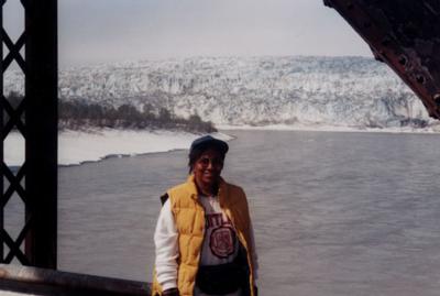
Child's Glacier from the Million Dollar Bridge.
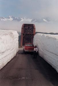
The wall of snow on the way to the Million Dollar Bridge.
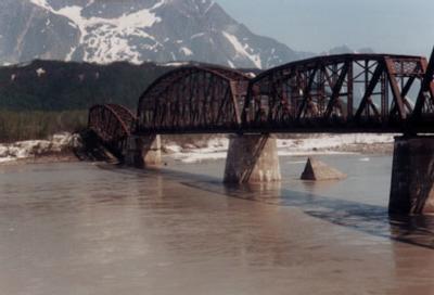
The Million Dollar Bridge across the Copper River.

Child's Glacier.
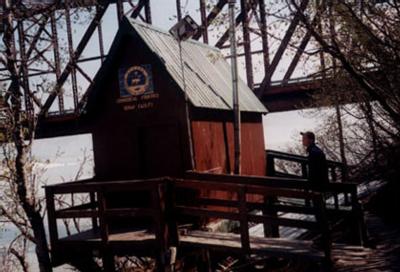
Alaska Department of Fish and Game's Sonar Station for monitoring fish movements up and down the Copper River.
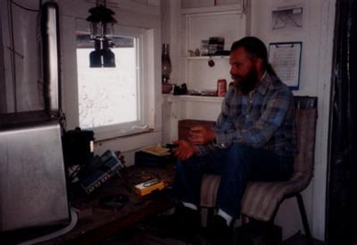
Inside the sonar station the equipment is monitored for salmon spawning up the Copper River.
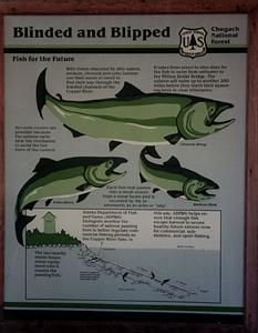
Posted information by the Chugach National Forest explains the method that the sonar station uses to monitor fish movements in the river to ensure that populations are healthy.
Contact the TEA in the field at
.
If you cannot connect through your browser, copy the
TEA's e-mail address in the "To:" line of
your favorite e-mail package.
|
