|
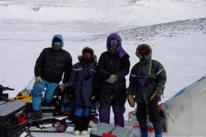
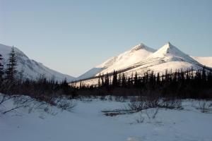
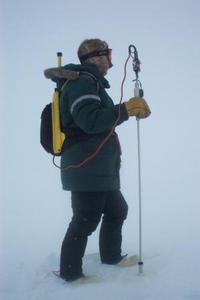
9 April, 2002Strap on a backpack, strap on the snowshoes, pull on the mittens and head for a walk. A walk out on the open tundra or through a snow covered forest or perhaps across a frozen lake. This walk needs to take the path of a straight line across the snow. A straight line where the wilderness has no boundaries and knows no restrictions. The backpack does not contain food or water. It contains a GPS system and a data recorder for the MagnaProbe. The GPS is a global positioning system that operates by satellites orbiting the Earth. GPS systems come in all shapes and sizes. The GPS's that we are using to navigate our trip fit in the palm of a hand. However, this GPS is much larger and requires the backpack. It is a more precise GPS and can have provide distance coordinates as accurate as a meter. The GPS unit has an antenna that sticks outside of the backpack. This antenna receives signals from the satellite to the GPS system. The MagnaProbe is an instrument designed and made by, SnowSTAR's very own, Jon Holmgren. The MagnaProbe is a very handy way of measuring and recording snow depth. It consists of a rod that is approximately 1.5 meters in length. At the end of the probe is a white basket that will ride on the top of the snowpack. At the top of the probe is a white control button. This button is pushed to record the snow-depth measurement. All of the snow depths are recorded in the data box that is strapped to the waist belt of the backpack. Without the MagnaProbe, depth measurements would be much more difficult. A person would have to write down all of the depth numbers. Writing with mittens on is a very difficult task to do!!! Jon's MagnaProbes are an ingenius invention! I have been thankful many times! Beep, beeep, beeep…. One, two, three, four, five, six, seven and eight… BEEP, beeep, beeep. Walk again… These are the sounds of the MagnaProbe and GPS working together. Jon has wired them so the both measurements can be recorded at the same time. On a typical long walk, 200+ measurements are recorded over a mile in distance. The invention of the MagnaProbe has allowed us to record and store more measurements in a given day. The more data collected during a science expedition allows for better analysis and results. WHERE IS MRS. CHEUVRONT?? LET'S PLOT!! Latitude:67.63113 degrees North Longitude: 157.37863 degrees West Howling winds, frozen rivers, wind-sculpted snow, avalanche slides, deep valleys, and massive, snow-covered rock-topped mountains. Entrance into the Brooks Range mountains.... A mystical, enchanting, daunting place. Ivishak pass was the name of our doorway through the beginning of the Brooks Range. The mountains lay steeply on both sides of us, hovering above, allowing the winds to flow heavily through the pass. The winds at times reached 40-50 mph. The snowmachines bumped heavily along the hard, wind-scoured snow. Footprints of wolves, foxes, and grizzlies were the only signs of noticeable life. The wind and the cold reminded us how remote and wild these mountains are. We stopped at the top of a peak to perform a remote Class 2 chemical sampling. The wind cut through the thin latex gloves. As a team working together we accomplished the task. The safest and best way to travel was hard to determine at times. Matthew and Eric would lead the way using the maps and GPS. Scouting the best route proved to be troublesome with our snowmachines frequently getting stuck in the deep snow. Tonight we camp in the heart of the Brooks Range. The mountains have brought us deep snow on the ground and light snow in the air. The wind is calm in our camp. Tomorrow, we travel deeper into the mountains. Temperature Min: -18 degrees Celsius High winds today. Temperature Max: -12 degrees Celsius Matthew Sturm USA-CRREL-Alaska P.O. Box 35170 Ft. Wainwright, AK 99703 907-353-5183 msturm@crrel.usace.army.mil
Contact the TEA in the field at . If you cannot connect through your browser, copy the TEA's e-mail address in the "To:" line of your favorite e-mail package. |