|
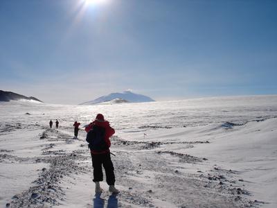
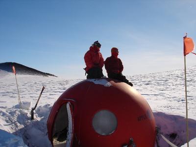
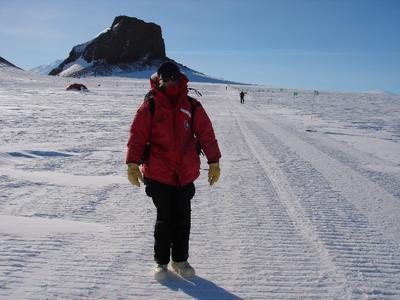
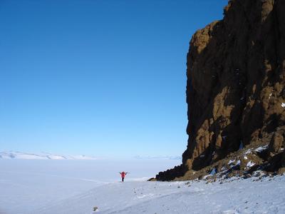
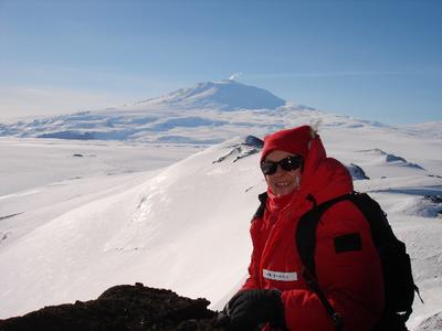
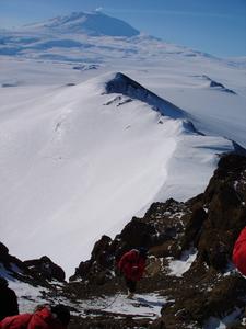
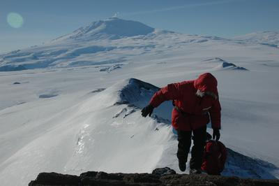
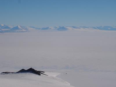
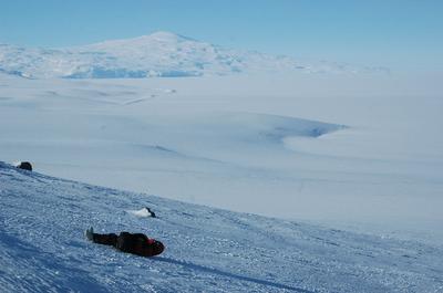
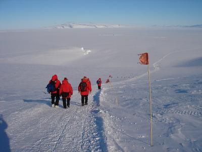
24 October, 2004An eventful weekend. I spent most of Saturday working on the Science Lecture I was scheduled to give Sunday night. A busy day. On Sunday, we had brunch, then started off on a hike to Castle Rock, which is three miles from McMurdo station, farther up the Hut Peninsula (the long, skinny piece of land at the end of which is McMurdo station). I considered taking some cross-country skis that I had rented, but since everyone else was walking, and there was not much snow, at least near McMurdo, I decided against it. For the first part of the hike, I was really glad that I did not have skis. The hike begins with a long hill, which had no snow on it. The views of McMurdo Sound and the mountains on the other side of the sound just kept getting more spectacular as we climbed. At the top of hill, we got onto the official Castle Rock trail, which IS covered with snow, in fact it goes across a large snow field that goes all the way over to Scott Base, the New Zealand station. The whole trail is marked with flags and it's very important to stay on the trail. Underneath the smooth surface of snow are very deep crevasses, or cracks. In the mid 90s, a group was on the Castle Rock Trail as we were, when some bad weather came through. They decided to take a shortcut by walking straight across the snow, trying to get to shelter sooner. Two people fell into a crevasse and were killed. In some places where we walked, there were even crevasses marked with flags right near the trail. We stopped twice on the way up and sat for a few minutes in the "apples," round red fiberglass shelters that have emergency supplies - such as a stove, food, sleeping bags, and a first aid kit. It was a beautiful day, so we were quite warm most of the time. You have to pay attention to not getting too sweaty at first, though, climbing the hill. It's easy to get hot, sweat, and then get chilled because you're wet. It's better to take off a few layers if you're going to be doing something that's even a little bit strenuous, then bundle up again once you stop. As we walked up toward Castle Rock, the view became even more gorgeous. Erebus was steaming up ahead of us and we could look out way over the Ross Ice Shelf to our right. To our left there was a rock outcropping with a view of the mountains across the sound in the distance. When we reached the base of Castle Rock, we had to walk up a rather slippery slope to get to the rocky surface that was easier to stand on. There were two guys with a sled going down the side of it onto the flagged trail. A sled can get going pretty fast there! Once we reached the rock, it was definitely easier climbing, although trying to do anything other than just walking in the "bunny boots" is a bit of a challenge. They're very warm, but make your feet about twice as big as they usually are, and are therefore a little awkward. The climb wasn't too bad anyway, and there was rope to hold onto in two little sections. Once we got to the top, everyone was stunned by the view. We could see a long way in all directions, except for the area that was dominated by Mount Erebus, Mount Terror, and Mount Terra Nova. (These three mountains, by the way, are named after ships of early Antarctic explorers. The Erebus and the Terror were the two ships of James Ross, who led an expedition to Antarctica from 1839 to 1843 and the Terra Nova the ship Robert Scott used in his fatal attempt to be the first to reach the South Pole in 1911.) One thing that we amazing was to be able to look DOWN onto Cinder Cones and see our dive hut as little more than a tiny speck on the ice below. We could also look out over Tent Island, Inaccessible Island, Big and Little Razorback, and the Erebus Ice Tongue Glacier. We could also see across to the Royal Society mountain range, and see several glaciers on the other side of the sound. We stayed on the top of Castle Rock, enjoying the sun and the scenery and the quiet. Little ice crystals were blowing around in the air, sparkling. After a group photo, we climbed down the rock again. Again of us was the trail, at the bottom of a steep slope. There was really no way down except to put up your hood and slide upside on the back of your parka. It was fun, but ended too soon. We continued on the trail to the other side of the Hut Peninsula, where we looked out across at White and Black Islands. We could also see "Willy" Field, one of the three ice runways at McMurdo, although not the one we landed on when we arrived. We could see "Snow Mound City," the location of Happy Camper School. All of these were to the left, or southeast of us as we walked. To the right, or northwest, were big walls of snow, ice, and eventually, rock and snow. The wind was blowing the snow over the top and down the steep slopes in dry, wispy rivers. Every now and then, we could really see just how treacherous the snow was underneath the soft, smooth surface, as there big, exposed holes in the walls next to us. We walked until we reached Scott Base, the New Zealand station, where all the buildings are painted a bright "kiwi" green. From there, we got a van ride back to McMurdo so that we'd be back in time to have dinner and for me to give my talk at 8:15. I was nervous about speaking to such a large group of people - 100 or more, but pretending to be calm and eating way too much dessert seemed to help. It actually turned out to be kind of fun and I met a lot of nice people who came to talk to me afterward. All the folks from my group were very supportive, which also helped a lot. They did not throw even one piece of rotten fruit while I was speaking!
Contact the TEA in the field at . If you cannot connect through your browser, copy the TEA's e-mail address in the "To:" line of your favorite e-mail package. |