|
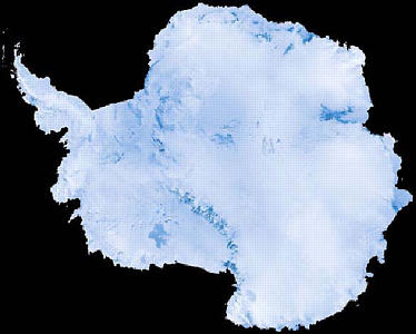
16 February, 1999February 16, 1999 Hello from Antarctica! Today, we’ve been continuing our multibeam survey in the Ross Sea. We were able to make a really nice map with the data that we collected. After we edit all of the data, the map will be even nicer! Tonight, we are beginning a long seismic survey. For this, we will be facing south for almost 24 hours. As a result, we won’t have any email communications . . . and this journal may be a little late in getting posted. This afternoon, I received a telephone call from the bridge. There were whales outside! I ran up to the bridge (all five sets of stairs) with my cameras and tried to take some pictures. You really couldn’t see the whales, but you could see the sprays of water. The digital pictures didn’t turn out too well because the whales were too far away. In my opinion, however, they seemed pretty close to the ship. I hope we see some more! Tonight I had my first few minutes of free time. Due to the fact that PJ helped me get some of my data editing finished early, I was actually able to practice my flute for a few minutes. Do you know how difficult it is to find a place to practice my flute on this ship? Because people from the opposite shift are sleeping when I’m awake, I have to find a place that is relatively soundproof. I ended up finding a little lab room attached to the helicopter deck on the 3rd floor. It was really nice. Did you figure out the answer to yesterday’s question: “How large is Antarctica, compared to the size of the United States?” It is nearly the size of the United States and Mexico put together! Around 200 million years ago, Antarctica was a part of the supercontinent called Gondwanaland. It was located much further north, and it was joined to Australia, Africa, South America, India, and New Zealand. Gondwanaland broke into pieces, and the continents began to slowly move into their current positions. It is believed that Antarctica detached from South America about 70 million years ago and that it reached its present position about 45 million years ago. Some of the scientific evidence for this is in fossils. Fossils of a deciduous conifer (Glossopteris), a fern (Dicroidium), and a terrestrial reptile (Lystrosaurus) have all been found in Antarctica. These fossils have been found in rocks that date back to the age of Gondwanaland. In addition, similar fossils in rocks of the same age have been found in India, South America, Australia, and Africa. The only way this could have happened is if the continents were connected at that parcticular time in history. If you look on a map today, Antarctica looks somewhat like the head of an elephant with its small trunk pointing up towards South America and its mouth opening into the Ross Sea. The “trunk” is referred to as the Antarctic Peninsula. The continent is divided into two parts by the Transantarctic Mountains. West Antarctica is the smallest part, and actually consists of a series of islands that are permanently covered by ice. East Antarctica is sometimes referred to as Greater Antarctica, and the land beneath the ice is much larger. If the entire ice sheet were melted, the size of the Antarctic continent would be cut in half. Antarctica is the coldest, highest, windiest, driest, and most isolated of all the continents. The average temperatures in the interior of the continent range from 40 to 70 degrees C during the Antarctic winter. The coldest temperature ever recorded on earth was established at the Russian Vostok Station when the thermometer dropped to 89.6 degrees C! During the warmest months, interior temperatures range from 15 to 35 degrees C. I’m sure that you have noticed that our temperatures are considerably warmer than that. Near the coast (and on the water), the temperatures are moderated by the water, which is actually warmer than the land. Coastal winter temperatures range from 15 degrees to 32 degrees C, and summers warm up to +5 degrees C around the Antarctic Peninsula. Antarctica is considered the highest continent in the world because it is covered with a huge icecap that we refer to as the ice sheet. For tomorrow’s question, how tall is that ice sheet? And how did it form? Antarctica experiences the strongest winds on the planet, which can actually reach speeds of up to 320 kilometers per hour. These are caused by dense, cold air rushing down from the middle of the continent towards the coast, and they are called katabatic winds. The wind speeds at the Pole itself aren’t that great and usually stay below 30 km/hr. Most people are surprised to learn that Antarctica is actually the world’s driest desert. Although blizzards can occur, very little snow actually falls. Blizzards are caused by winds blowing snow along the surface. Well, that’s about all for today. Keep your questions coming . . . I love getting the email! See you tomorrow! Kim Giesting Latitude: 76 degrees 07 minutes South Longitude: 170 degrees 02 minutes West Temperature: -4 degrees C
Contact the TEA in the field at . If you cannot connect through your browser, copy the TEA's e-mail address in the "To:" line of your favorite e-mail package. |