|
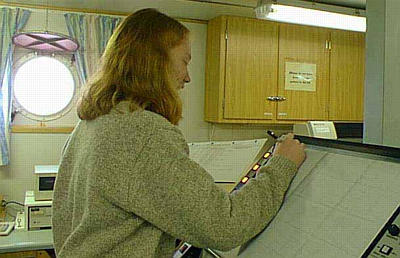
17 February, 1999February 17, 1999 Hi from the Nathaniel B. Palmer! When I woke up this morning, I noticed that the ship was only traveling at about 5 knots, rather than the 10-12 we have been averaging. Do you know what knots stands for? It means nautical miles per hour, and one nautical mile is equal to one minute of latitude or about 1.1 miles. When I turned on my television monitor to find out why we were going so slowly, I realized that we were towing a seismic gun and streamer. We call it shooting seismics. This process uses sound waves to determine the large-scale vertical profile of the sediments. Behind the ship, we tow a huge "air gun" and a long flexible tube (called a streamer). The "air gun" shoots out a large bubble of air, which creates a compressional wave. When this happens, a loud pop is created and those waves travel down to the ocean floor. Some waves bounce off the surface of the sediments, but others bounce off specific layers of sediments beneath the surface. The streamer contains things called transducers (we call them phones) in it that listen for the return of the sound waves and record how long they take to get there. In the dry lab, we have a computer monitor that records this information and we have a printer that makes a printout of what the seafloor (and the layers beneath) looks like. We are specifically looking at the top 250 meters of sediments with this instrument (although it penetrates much deeper). Other scientists may use much larger guns to penetrate all the way down to the earth's mantle! The line that we are "shooting" is nearly 28 hours long and it extends across the Ross Sea from the continental shelf break (where the slope quickly descends down to the deepest parts of the ocean) to the Ross Ice Shelf . . . about 140 miles towards the land. Let's take a few minutes to look at yesterday's question: "How tall is the ice sheet, and how did it form?" The ice sheet is the large mass of ice and snow that covers most of the Antarctic continent. Many sources describe Antarctica as being 98% covered by ice. Newer satellite images, however, show that ice covers 99.6% of the continent. Antarctica's ice sheets contain 90% of the world's ice and are said to contain between 70-85% of the world's fresh water. Because Antarctica is the driest continent on Earth, the amount of snow deposited in any one year is relatively low. But Antarctica is also very cold, so the snow has accumulated over many thousands of years without melting. As snow is deposited year after year in the interior of the ice sheet, it consolidates to form ice. The ice sheet averages over a mile thick, and it is almost 3 miles thick in some places. You can imagine that the weight of that much ice is very great. As a result of pressure created by the weight of the ice sheet, the ice flows from the high interior of the continent towards the lower Antarctic coast. At the coast, large pieces break off the ice sheet to form icebergs. In some areas, the ice sheet slides off the land and floats on the water . . . which is an ice shelf (like we talked about on Feb. 14th). In slightly warmer climates, ice is removed from ice sheets mostly by melting. Only in a polar setting such as Antarctica is the calving of icebergs the major way that ice is removed from the ice sheet. (Do you remember the term “ablation?”) The Antarctic ice sheet has two parts -- the East Antarctic Ice Sheet and the West Antarctic Ice Sheet. The East Antarctic Ice Sheet is more stable than the West Antarctic Ice Sheet. This is because the land beneath the East Antarctic Ice Sheet is almost entirely above sea level. This is called a "land-based" ice sheet. Land-based ice sheets are believed to be very stable and react very slowly to changes in the environment. The West Antarctic Ice Sheet, however, is considered a "marine-based" ice sheet. This means that the base of the ice sheet sits on rocks that are mostly below sea level. In some locations, the West Antarctic Ice Sheet rests on rock over one mile below sea level. Polar ice sheets are considered stable as long as the amount of ice that is added to an ice sheet by precipitation equals the amount of ice that is removed by making icebergs. In marine-based ice sheets, it is easier to upset that balance and lose more material than is gained -- which causes the ice sheet to break down. Marine-based ice sheets can be affected by many different factors, including the flow speed of the ice and the temperature of the ocean. Ice shelves form a direct connection to the ocean and they are an easy way for the ice to thin and break apart on a marine-based ice sheet. A few days ago, we discussed the disintegration of some ice shelves near the Antarctic Peninsula. Researchers are currently studying the West Antarctic Ice Sheet to predict its future stability. In fact, our research here in Antarctica is a small part of the WAIS Initiative (West Antarctic Ice Sheet). The WAIS Initiative is a collaborative study by researchers from many fields of discipline and from many different universities. There are some estimates that the West Antarctic Ice Sheet could collapse within the next 1000 years and cause sea levels to rise as much as 20 feet. Scientists want to have a clear understanding of ice sheets in order to understand what is happening today and predict what will happen in the future. There are two theories, or models, for this. One is that the ice sheet will collapse in a relatively short period of time, and the other is that the ice sheet will retreat very slowly. Our research is looking at features on the sea floor to determine how the ice sheet behaved in the past (since the last glacial maximum, approximately 20,000 years ago). Scientists believe that if they can determine how the ice sheet behaved in the past, they may be able to predict how it will behave in the future. Tomorrow, we'll look at some of the other pieces of equipment that we use to study the sea floor. Do you know how sonar works? We sure depend on it a lot. See you the next time! Kim Giesting Latitude: 77 degrees 41 minutes South Longitude: 168 degrees 43 minutes West Temperature: -6.5 degrees C
Contact the TEA in the field at . If you cannot connect through your browser, copy the TEA's e-mail address in the "To:" line of your favorite e-mail package. |