|
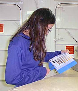
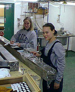
20 February, 1999February 20, 1999 Hello from the Ross Sea! Well, it wasn't as beautiful outside as it has been -- in fact, it was really gray outside all day today. We had a great day inside, however, and collected lots and lots of seismic data. The seismic line will continue tonight and into tomorrow. After that, we will be doing a multibeam survey and taking some cores before we move out of the Ross Sea. I can't believe how quickly the days are going! We've already been at sea for over a week now . . . it's amazing. I'm really having a great time! I love science, I love education, and I love exploring new places -- so what could be better? Due to the fact that we weren't taking any cores today, we had a little extra time to finish analyzing yesterday's kasten cores. Yesterday's question was "What types of things do you suppose we look at when we analyze the core?" Some of the most important things are the color, the grain size, the amount and size of rocks or gravel, the boundaries between two different types of sediments, and the amount of the mud's stiffness. The first thing we do when we open up a kasten core is put a measuring tape against the core and take pictures to document how the sediments looked before they were disturbed. After that, we describe the color by using a small spatula of mud and comparing the color changes to a color chart. Green mud indicates that diatoms lived in the water above that mud. They sank to the bottom after they died, and their color turned the sediments green. Diatoms are algae that need sunlight to survive. They use sunlight as energy to make their own food (like plants). When we find diatoms in the sediments, we know that the area we are studying was NOT covered with ice when the diatoms were living. Similarly, gray mud indicates an absence of diatoms . . . which could mean that there was no sunlight . . . which could indicate that the area was covered by ice (perhaps an ice shelf) at that point in history. Scientists can take a core of sediments, have the layers dated (we know the oldest layers are on the bottom, but they want more exact dates), and use this information to help figure out the glacial history of the area. Sometimes, the sediments found in the cores contain small rocks. These rocks are evidence that an ice sheet used to be nearby. Rocks can be picked up by an ice sheet and become frozen in the ice. Once the ice sheet reaches the coast, icebergs calve off. The icebergs begin to melt, and the rocks drop to the bottom of the ocean. We call these rocks dropstones. In other cores, the sediments may contain a lot of ground up rock material that could have been formed directly beneath the ice sheet as rocks were crushed and pulverized under its heavy weight. Sediments formed like that are called glacial till. After we are done describing the core, we take a mini-core to send back to the United States for further analysis. In order to do this, we use a piece of PVC pipe that is sliced in half (lengthwise). We put the open side of the pipe on top of the sediments and push down very hard. By using piano wire to slice the mud before we slowly turn the pipe over, we can then get a good sample of the sediments to archive. We cover the pipe with plastic wrap and a thin piece of plywood, using strong tape to make sure that they are firmly bound together. These subcores are then labeled and tested for magnetic susceptibility before they are put in the cooler with the piston and trigger cores. The remaining kasten core sediments are then sampled for individual research projects. Some samples are taken for analysis at Rice University and Florida State University. Broxton takes samples in order to test the water content of the sediments. Diane and PJ are looking for microscopic plants and animals. Once everyone has taken everything that they need from the core, the core barrel is thoroughly washed out so that it is ready to use again. The whole process takes two to three hours. I've had several questions about how we know our exact location when we can't even see the land. What methods could we use to determine our location? How do these methods compare to what the earliest Antarctic explorers used? We'll look at that in tomorrow's journal. Don't forget . . . if you have any questions, you are more than welcome to email them to me! Kim Giesting Latitude: 77 degrees 41 minutes South Longitude: 162 degrees 54 minutes West Temperature: - 0.8 degrees C Barometer: 987.5 mb Wind speed: 18 knots Wind direction: 339 degrees (0 = north; 90 = east; 180 = south; 270 = west) A wind direction of 339 degrees means that the wind is coming from the northwest.
Contact the TEA in the field at . If you cannot connect through your browser, copy the TEA's e-mail address in the "To:" line of your favorite e-mail package. |