|
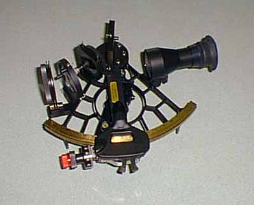
21 February, 1999February 21, 1999 Greetings from the N.B.P! Today we finished our last seismic line in the Ross Sea. Tonight and tomorrow, we will be multibeaming and collecting piston/trigger cores along today's seismic line. After that, we’re going to be transiting to our next location. The ETs (electronic technicians) are making progress on fixing our side scan sonar (the fish). Today, we even put it in the water to try it out. It still needs a little work, but we are getting optimistic! The goal is to put it back in the water later tonight. Can you imagine trying to fix everything that broke around your home without going to the store to pick up the parts that you need? In addition, I think it would extremely difficult to fix things while on a moving ship that is rolling back and forth! Let's take a few minutes to look at yesterday's questions. They were, "What methods could we use to determine our location?" and "How do these methods compare to what the earliest Antarctic explorers used?" On the Nathaniel B. Palmer, we use GPS to figure out our exact latitude and longitude. GPS stands for Global Positioning System, and it uses satellites that are up in space. Currently, there are at least 24 GPS satellites going around the Earth. To determine your position, you need to be able to receive information from at least three satellites (the more satellites, the more accurate your information). If you want to learn your elevation too, you need information from at least four satellites. These satellites send out information including which satellite you are using and the time that the signal was sent. Receivers on the ship use that information to calculate how far the satellite is from the ship (we know that the information travels at the speed of light). With at least three points, the receivers use triangulation to determine the ship's exact location. On this ship, we receive an update on our exact latitude and longitude every second. This information appears on our television screens where we are able to monitor all of the equipment. We do not have to use the GPS system manually -- we take our navigation for granted This method of determining location is used by people all over the world. It is not just used for the navigation of ships. The earliest explorers didn't have satellites or receivers to help them know their exact location. They didn't have telephones, email, or even ham radios for communication. They were on their own, for several months to several years at a time, and had to use an instrument called a sextant to determine their latitude and longitude. In order to use a sextant, you must be able to see either the stars or the sun. If the skies are cloudy, a sextant can't be used. To use a sextant, you begin by looking through it at a parcticular celestial object. Captain Joe showed me how to use a sextant, and I used it to look at the sun. By adjusting a knob on the side of the instrument, you can adjust the height of the sun (or a star) so that it appears to be sitting right on the horizon. Once that is accomplished, you can determine the altitude of the sun (distance above the horizon) by how much you had to turn the knob. Once you have that information, you need to know the exact time (GMT, or Greenwich Mean Time), and you need to fill out an entire page of mathematical equations. If you are using a sextant at night, the altitude of three different stars must be used (and one page of equations must be filled out for each star). The result is knowing your latitude and longitude. One of the most difficult tasks for early explorers was determining the exact time. The British Government offered a reward in 1714 to any person who could manufacture a timepiece that would keep accurate time in any weather. It wasn't until 1762 that such a chronometer was tested successfully! Of course, if you were sailing in the Northern Hemisphere, it would be very easy to determine your latitude by looking at the North Star. The distance above the horizon to the North Star is the same as your latitude. If you were to look at the North Star from the North Pole, it would be directly overhead. That would be 90 degrees above the horizon, and the latitude of the North Pole is 90 degrees North. If you were to look at the North Star from the equator, it would be right on the horizon. That would be an altitude of 0 degrees above the horizon, and the latitude at the equator is 0 degrees. So, if the North Star is 40 degrees above the horizon, you are located at 40 degrees north latitude. The North Star is not visible in the Southern Hemisphere, however. In addition, since we are in Antarctica there are many months of the year when there are 24 hours of daylight and no stars are visible at all. I can't believe that another day has gone by so quickly! Our day today started with an awesome breakfast and ended with a terrific dinner! What types of food do you think that we eat on the ship? Tune in tomorrow to find out! Until then . . . Kim Giesting Latitude: 76 degrees 33 minutes South Longitude: 163 degrees 18 minutes West Temperature: -4 degrees C Barometer: 995.4 mb Wind speed: 11 knots Wind direction: 320 degrees (winds are coming from the northwest)
Contact the TEA in the field at . If you cannot connect through your browser, copy the TEA's e-mail address in the "To:" line of your favorite e-mail package. |