|
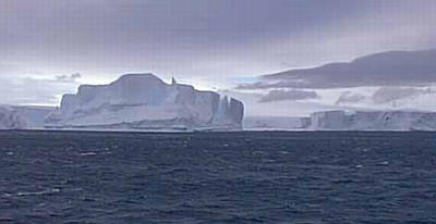
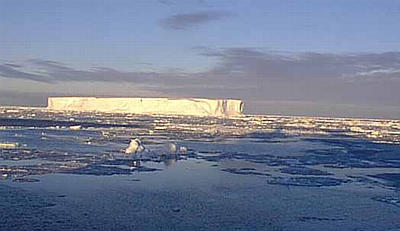
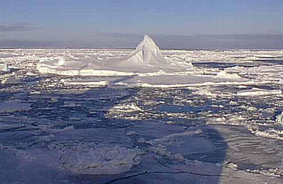
3 March, 1999March 3, 1999 Hi from the Nathaniel B. Palmer! This morning was absolutely beautiful when I woke up!!! Then sun was shining, the sky was blue with a few clouds, the winds were calm, and the seas were glassy with lots of sea ice and icebergs. It was amazing! I kept running outside to take picture after picture. I couldn't help myself . . . it was so beautiful. By mid-morning, the clouds were already starting to fill the sky and the winds were beginning to pick up. By late morning, we had 40 knot winds and the sky was totally gray. I couldn't believe how quickly things changed. During the night, the ship began its transit out of Wrigley Gulf and towards the Walgreen Coast. We ran into a bit of a surprise, however, when we found thick pack ice in areas that were ice-free just a few days ago. I guess that storm really blew some of the sea ice around. At any rate, the ship had to go around a large portion of the ice and then slowly moved through the rest of it. It wasn't until we went around Siple Island that I realized how much Mt. Siple had been protecting us from the strong winds. I tried to go outside and take another picture . . . and I could barely get the door open! The winds were so strong. Once we got out into the winds and away from the ice and the land, the waves started picking up again. In addition, I think we're headed toward another storm system. Let's take a moment to look at yesterday's question: "How do winds affect the height of waves?" As you know already, they affect the waves a great deal. The height of the waves depends on three things: the wind speed, the wind duration, and the fetch. The wind speed is how fast the wind blows. Yesterday, we talked about the Beaufort Wind Scale -- Strong Gale winds cause higher waves than Fresh Breeze winds. The length of time that the wind blows is the wind duration. It only makes sense that 50 knot winds for 3 days cause higher waves than 50 knot winds for 10 minutes. The fetch is the distance that the winds travel over the water. Here's where land and ice can help us out! The longer the wind blows over the open water, the higher the waves. Water partly covered by ice or protected by land doesn't have a large fetch, so the waves are smaller. Here in Antarctica, the seas are extraordinarily calm or even completely still in heavy pack ice. Of course, there are never any waves if the sea surface is totally frozen. Here is a scale that is used to describe the height of the waves: 0 waves calm, glassy 0 - 4 inch waves calm, rippled 4" - 1.5 foot waves smooth, wavelets 1.5' - 4' waves slight 4' - 8.2' waves moderate 8.2' - 13' waves rough 13' - 20' waves very rough 20' - 30' waves high 30' - 46' waves very high 46' + waves phenominal I talked with Mike, who is one of the Mates, today. The Mates are the people who help the Captain drive the ship. Mike has been a Mate on the Nathaniel B. Palmer since it first set sail in 1992. I asked him how high the waves were during the last few days. His reply was very surprising to me -- he said we had 15 foot high waves yesterday! Although I knew that the seas were a little rough, I didn't realize that the waves were that high. I then asked him about the highest waves that he has even seen while aboard the Nathaniel B. Palmer. He said that he drove this ship in 60 foot waves two years ago! The bridge of the ship (where they drive it, 5 decks up) is 60 feet above the water level. That means that the waves were as high as the bridge. Of course, that doesn't mean that the waves were breaking on the ship. You have to remember that when you are away from the shore, waves are just hills and valleys of water that the ship goes over. It isn't until the waves approach shallow water that they begin to break (like you see at the beach). Well, tomorrow evening we should be arriving at the Dotson Ice Shelf on the Walgreen Coast. During our transit, we'll be moving our clocks ahead another hour -- so we'll only be three hours behind the time in Indiana when I write the journal tomorrow night. Once we arrive, we'll be running a multibeam survey and a seismic line there that will probably last less than 24 hours. After that, we'll be heading towards Pine Island Bay. All of these locations are found in the Amundsen Sea. Who was Roald Amundsen? We'll look at that in tomorrow's journal. Thanks for all of the great email questions . . . I love it! Kim Giesting Latitude: 73 degrees 01 minutes South Longitude: 123 degrees 03 minutes West Temperature: -2.5 degrees C Barometer: 981.6 Wind Speed: 31.8 knots Wind Direction: 96 degrees (from the Southeast) Sunrise: 03:53 Sunset: 19:03
Contact the TEA in the field at . If you cannot connect through your browser, copy the TEA's e-mail address in the "To:" line of your favorite e-mail package. |