|
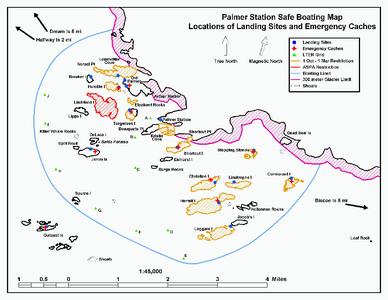
20 April, 2003I thought that today I would introduce you to the sea area around the station that I travel to when I am tending divers. I have included the map that we get when we take Boating I and Boating II. There is a copy of this map in each boat for use by the tenders in getting the divers to the correct dive site. I hope that it will be able to orient you to the area. Now you can go back to some of the earlier journal entries and calculate where I have been in relation to the station. I hope this also helps you in ascertaining where I am working in future journal entries. Along with the map, I have made a list of the locations I have visited. Following is a brief history of each. Eichorst Island was named after an amateur radio operator that handled the radio traffic between the US and Palmer Station from 1964-1972. Christine Island is named after the wife of a biologist who worked with her husband on the island studying penguins. Hermit Island was named after a British member of the original surveying team that spent some time alone there on the island. Cormorant Island is named after the cormorant bird. Palmer Station personnel named Shortcut Island because it is a shortcut from the station to the Biscoe Bay area. Norsel Point was named after a Norwegian sealing vessel, the Norsel. Now, I will provide you with information on the other geographic landforms in the Palmer Station research parameters. Breaker Island was named by surveyors for the breakers on the shoreline caused by rough seas. Humble Island is a small island squeezed in between 2 larger islands, Anvers and Litchfield. Litchfield was named for Douglas B. Litchfield, the general assistant and mountaineer at the Arthur Harbor Station in 1955 who helped with local surveying. Palmer personnel named Elephant Rocks appropriately as it is a favorite habitat for elephant seals. Torgerson Island was named for Torstein Torgerson, the first mate on the Norsel who was the first person to enter Arthur Harbor. Lipps Island was named after Dr. Jere H. Lipps, team leader of a research group studying shallow water benthic organisms along the Antarctic Peninsula. Split Rock was named by Palmer personnel in 1972 about one tenth of a mile from Janus Island. Janus Island is the southernmost entrance into Arthur Harbor and was named after the Latin god of mythology, the guardian of the gates. DeLaca was named after Ted E. DeLaca. His team researched terrestrial arthropods there. Scientists have devised an identification system to help them classify organisms. In hierarchical order these classifications are kingdom, phylum, class, order, family, genus, and species. Arthropods are in the animal kingdom and classified under the phylum arthropoda. These include insects and crustaceans. Although the ones here in Antarctica are tiny, they are not microscopic. They live in the mosses that cover the islands. Arthropods are the only true terrestrial animals in the Arthur Harbor area. Bahia Paraiso was an Argentine navy ship that occasionally ran civilian orientation cruises. She ran as the main re-supply vessel to the Argentine research stations in Antarctica. She was on her way to one of the Argentine stations with a year's supply of diesel fuel. The ship ran aground upon some shoals about 2 kilometers from Palmer Station near DeLaca Island on January 28, 1989 after a tourist's stop at Palmer. Palmer personnel named Surge Rocks in 1972 because the shoals around them cause ocean swells and a surge. Palmer personnel named Stepping Stones in 1972 because the rocks form small boat protection or stepping stones for those working in the Palmer area. Palmer personnel named Limitrophe Island in 1972 because it forms the limit of normal station operations. Jacob's Island was named for Lt. Cmdr. Paul F. Jacobs USN Officer-in-Charge of Palmer Station in 1972. Hellerman Rocks were named for Lt. Lance W. Hellerman Officer-in-Charge of Palmer Station in 1969. Laggard Island was named for its SW position on the eastern fringe of the Arthur Harbor island area. Spume Island is named for the spume or sea spray that blows over the island in a gale. I hope this information helps! I would like to acknowledge the Geographic Names of the Antarctic, Second Edition, 1995, for the wealth of data it has provided me on this trip. I would also like to thank the former and present personnel of Palmer Station for their expertise on the Arthur harbor island area and my research team, Dr. Chuck Amsler, Maggie Amsler, Dr. Anne Fairhead, Kevin Peters, Yushang Huang, and Stephanie Weiss.
Contact the TEA in the field at . If you cannot connect through your browser, copy the TEA's e-mail address in the "To:" line of your favorite e-mail package. |