|
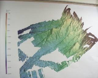
27 May, 2000Discovery in the Deep! Where are we? Does anyone have a map? Maps of the hidden world at the bottom of the ocean are helpful to scientists and others as they work to gain a better understanding of the Arctic. The maps guide scientists to places where they might want to sample the water or the sediments on the ocean floor. Using satellite data collected over many years, maps have been created that show us that our ocean floor is not flat, but instead has many high points, ridges, mountain ranges, and deep trenches. The problem with these maps is that they are not very accurate. With new technology, scientists can make maps of the ocean floor that are hundreds of times more detailed than the satellite maps. How are these new maps made? They are created with sound waves. Mounted to the hull (bottom) of the ship is something called a transducer. The transducer sends out a sound signal every second. The signal is called a “ping” because that’s what it sounds like. The pinging sound travels down to the bottom of the ocean where it bounces back to the ship like an echo. On the Healy they use a bottom mapping sonar system called SEABEAM that has many sensors across the bottom of the ship ‘listening’ for those pings to return. A computer on the ship records each ping that the SEABEAM makes. It also times each ping on its trip from the ship down to the ocean bottom and back up again. The longer it takes the ping to go from the ship to the bottom and back up to the ship, the deeper the ocean is at that point. If the ocean is shallow, the ping will make a quicker trip back to the sensor on the ship’s bottom. As each ping is heard, it produces a point of data for the map. Maps of even small areas can consist of millions of data points. That means that the ship must travel back and forth across a specific course many times gathering data. Kind of like mowing your lawn! The SEABEAM’s computer program helps scientists take all of these points and put them into a colorful, very accurate topographic map that shows what the bottom of the ocean looks like. These beautiful maps are sometimes full of surprises. Today the Healy scientists discovered a landform that no one has ever known about before. To find out about this discovery, click on: Click quick. You will want to be the first in your classroom to know! DAILY DATA LOG (5/27/00): air temperature: 8 degrees C / 45 degrees F latitude 50N longitude 45W
Contact the TEA in the field at . If you cannot connect through your browser, copy the TEA's e-mail address in the "To:" line of your favorite e-mail package. |