|
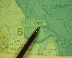
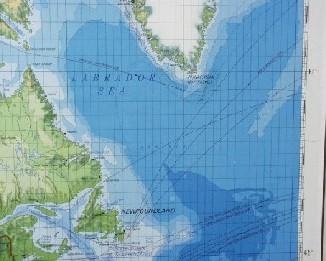
27 May, 2000Discovery in the Deep! Have you ever imagined discovering a new world, a world that no one has ever seen? You could start by looking at the bottom of the ocean. Deep below the Arctic waters lies a hidden world. There are mountain ranges, steep canyon walls, and rolling hills. No one knows exactly what it looks like because much of the landscape is unexplored. Satellite maps give us some idea of what landforms are there, but these maps aren't very accurate. It’s difficult to map an ocean that is covered with ice! If scientists want to create a detailed map of an area, they need to use a different kind of technology known as a bottom mapping sonar system. The sonar equipment scientists are using on the Healy is called SEABEAM. SEABEAM uses sound waves to "hear" what the bottom of the ocean looks like! Compared to a satellite map, which is based on only a few data points, a SEABEAM map has millions of actual data points for the same area. Imagine drawing a picture of a person by making one hundred dots on a piece of paper. You could only show a rough outline of the person's features. Then imagine drawing the same person using one million dots. You’ve just increased the resolution of your drawing. You could show a lot more detail with that many data points! That’s the same reason why the SEABEAM maps show more detail than the satellite maps. Today scientists using the SEABEAM made an amazing discovery. They found a small hill, or a knoll that wasn’t even on our map! The hill is located on the bottom of the Labrador Sea just north and east of Newfoundland. It is more than one mile below the surface of the ocean! One of the neat things about discovering a new landform is that you get to name it. The scientists designated the hill "Baby Knoll," because it is adjacent to a larger hill known as "Orphan Knoll." See if you can find Orphan Knoll on this map. To find out more about how the SEABEAM works, click on: DAILY DATA LOG (5/27/00): Air temperature: 8 degrees C / 45 degrees F Latitude 50N Longitude 45W
Contact the TEA in the field at . If you cannot connect through your browser, copy the TEA's e-mail address in the "To:" line of your favorite e-mail package. |