25 April, 2003
Where is Greenland and how do you get there?
From Eau Claire, Wisconsin, Greenland is about 3000 miles away. I
will be leaving on Sunday, April 27th from Minneapolis, Minnesota
flying to Albany, New York on a Boeing 747. Albany will be the
meeting point for our research team as many people are flying in from
different places in the United States. The following day we will fly
to Nova Scotia and then on to Kangerlussauq (Kanger), Greenland in a
C-140 military cargo plane. Kanger is our research staging area. We
will spend two or three days preparing for our trip to Greenland's
ice sheet before flying on a twin engine otter. Twin engine otter
are often used in Canada as float planes. In our case, this plane
will have skis instead.
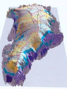
This is a 3 dimensional map showing the depth of ice over Greenland. If you look closely, the outer edges of Greenland do not have permanent ice however the inland regions have up to 3000 meters of ice! The two red dots are approximate areas where we will be drilling ice cores for later analysys. All of the other dots on the map are places that have been studied in the past. The red lines or individual regions that scientists have broken Greenland into for studying.
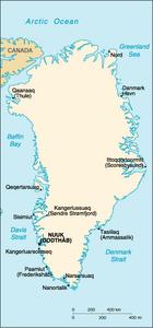
Look closely on the map and you will see a community named Kangerlussauq or Sondre Stromfjord. This will be our first stop in Greenland. It is an old military base where we can organize our gear before leaving for the ice cap. Each community has two names? What is the reason for this?
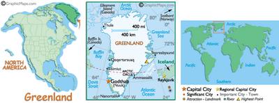
These pictures should help you visualize where Greenland is and allow you to compare where you are from to Greenland. >From the center picture compare the size of Greenland to the state you are from.
Contact the TEA in the field at
.
If you cannot connect through your browser, copy the
TEA's e-mail address in the "To:" line of
your favorite e-mail package.
|


