|
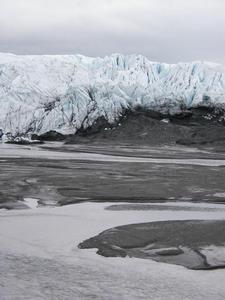
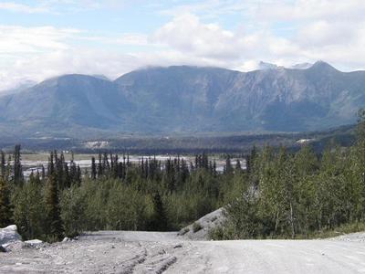
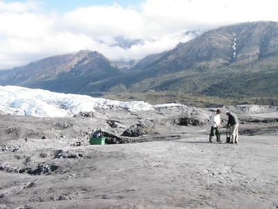
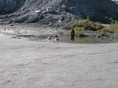
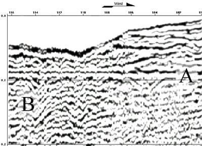
17 July, 2001Mud pits suck & ground-penetrating radar basics 8:00 p.m. Life on the ice.. .. (almost) During the summer, I try to wake up with the sun. So this morning, I woke up at 2:30 a.m. and again at 4:30 and then at 5:30, each time looking at my watch to realize it still wasn't time to get out of bed. My brain understands that "day" has lost its meaning, but my body hasn't. Last night, it never got dark... When I woke up at 2:30 a.m. to a gentle rain, it was light enough for me to read without having to use a flashlight. We set a relaxed pace today, arriving at the glacier around 10:30 a.m. Sitting on a moraine overlooking the terminus (end) of the glacier, Jeff Strasser (one of the principal investigators on the REU project, and the person partially responsible for affording me the opportunity to be here) outlined expectations to help keep the camp running smoothly and safely. One of the cautions: stay away from the mud and work in pairs. We didn't have long to wait to find out why both of these precautions are important. Shortly after the safety briefing, Jeff instructed us to get to know the glacier by looking for clues that would help us determine how the moraine we had been sitting on had been formed. Ranae and I walked around the outwash (meltwater from the glacier forming a stream as it emerges from underneath the glacier) and were taking some snapshots when a panicked woman approached, telling us that "A girl has fallen in a creavase and can't get out. My husband is waiting with her." The woman's daughter showed us the way. The girl hadn't fallen in a creavase (in which case rescue would have been near impossible if someone had even known to look for her). Instead she had tried to cross a mud flat on the hillside above the path to the glacier. The twelve-year-old girl had gotten turned around and saw the quickest way to the glacier was to walk across the mud flat. Apparently, after she sank into the mud up to her knee, she tripped. One of her legs was buried to the knee, one arm was buried to the shoulder. She had nothing to push against and so couldn't get out. Fortunately, her accident happened relatively close to the trail and she was able to call for help. Fortunately, Cory and Mike had just finished collecting data on the glacier and had a length of rope with them. We tossed her the rope, she looped it under her arms and we pulled her free. It took four grown-ups to free her from the mud. Her trapped shoe is still there. Don't walk on the mud. Don't travel alone.... Any questions? Science at work 11:15 p.m. This afternoon, Greg, Nelson and I took a sample run of ground-penetrating radar data. There are three key parts to the ground-penetrating radar: a transmitter to send out radar signals, a receiver to capture signals sent out by the transmitter, and a computer to tell the transmitter when to fire and to collect data from the receiver. A transmitter fires an electrical signal into the ground. When the signal reaches an object or layer with different electrical properties, part of the signal is reflected back to the surface. These reflected signals are captured by receivers on the surface. By measuring the time delay between when the signal was sent and when it is received back at the surface, one can infer the depth and location of the object or layer. With practice, it is possible to infer a great many more details besides. This afternoon, we hooked the transmitter and receiver to the computer and measured a line about 20 m long on a "slump" overlooking the glacier (see picture below). Nelson and I placed the transmitter and receiver 50 cm apart and took measurements. We repeated the procedure 10 cm farther down the line... again and again. Our data (with some fiddling) are also shown below. Inferring the details in a picture is a bit like watching TV or listening to songs that aren't coming in clearly. With practice, it becomes easier to understand and interpret what is being shown and said. Interpreting these data (Greg assures me) is a bit the same. Cheers. ~SM
Contact the TEA in the field at . If you cannot connect through your browser, copy the TEA's e-mail address in the "To:" line of your favorite e-mail package. |