TEA Banner
TEA Navbar


Tap Student Interest by Tapping into Polar Science

A Poster Presented by Scott McComb and his research team at the Geological Society of America Annual Meeting in Boston, Massachusetts in November 2001.
Download the PDF File of the Poster


Greetings from Columbus, Ohio!

My name is Scott McComb. I teach 7th grade science at Franklin Alternative Middle School in Columbus. In Columbus, 7th grade science is a combination of physical, earth, life and space sciences. At our school, there are approximately 600 students from sixth to eighth grades.

I arrived in Columbus circuitously, having grown up in Park City, Utah; studied abroad for a year in Mexico; attended college in Middlebury, Vermont; interned in Washington, DC; completed a teacher preparation program at UCLA; and taught for two years with Teach for America in inner-city Baltimore. After moving to Columbus, I worked for several years with an educational facilities consulting firm before returning to the classroom in 1998.

When I was in college, I designed and proposed an "Everything" major. The dean politely pointed out the breadth of courses was commendable, but the depth was not, so I declared a double major in physics and philosophy instead. Three years later, I graduated with honors.

Along the way, I became passionate about science education. For my senior thesis in physics, I authored a physics handbook for elementary science teachers, with everyday examples of numerous physics concepts and simple activities to teach those concepts. The handbook has been distributed to over 500 Vermont elementary science teachers.

Since then, I have taken dozens of additional courses in education and science. Geology and biology are parcticularly exciting to me.

I love science because the web of our knowledge grows through science, as does our wisdom (eventually). I love teaching science because it provides a forum to impart vital skills and valuable knowledge within the framework of positive, long-term relationships. I look forward to integrating lessons learned from TEA into my classroom and helping other teachers do the same.

Besides teaching, my other school-related responsibilities include coaching the Science Olympiad team, coaching the volleyball team, acting as faculty advisor to the web design team, writing curriculum for the district, designing staff in-services, organizing the 7th grade science fair, and mentoring student teachers. It's enough to keep me out of trouble anyhow. In the spring of 2000, I was named Teacher Exemplar by the superintendent of Columbus Public Schools and earned USI certification.

I use summers for playing tennis, cycling, reading (and nodding off) in the hammock, taking classes, traveling, camping, running rivers, jumping from airplanes, gardening, cooking vegetarian food, and other relaxing activities.


Scott's 2004 Arctic Experience:

TEA teacher Scott McComb has been selected to work in the Arctic during the summer of 2004 via the TREC Program (Teachers and Researcher Exploring and Collaborating).

TREC is a program facilitated by ARCUS and VECO and sponsored by the National Science Foundation Office of Polar Programs Arctic Sciences Section.

From the TREC site:

Follow Scott McComb as he travels north of the Arctic Circle to the Toolik Field Station in Alaska in order to study pollutants in Arctic freshwater systems. Scott will work with Yu-Ping Chin from The Ohio State University and other team members to collect and analyze water samples in Toolik Lake in order to understand the effect of pollutants on Arctic ecosystems.

Scott teaches high school physical science and physics at Fort Hayes Metropolitan Education Center in Columbus, Ohio and also instructs a college-level "Science by Inquiry" class. Scott has parcticipated in several field research projects and has received numerous awards for excellence in teaching. Scott expects to use his TREC experience to convey polar science not only to his classroom but also to larger audiences through curriculum writing and workshop presentations. To learn more about Scott's work in Toolik please read his TEA journal and check out the TREC site http://www.arcus.org/TREC/phpbb/portal_toolik_pollutants.php


Scott's 2001 Polar Experience:
Using Seismic Reflection and Ground-Penetrating Radar to examine shallow stratigraphy of the Matanuska Glacier, Alaska
Dr. Greg Baker, SUNY-Buffalo

In July 2001, I will be working with Dr. Greg Baker (University at Buffalo) on 
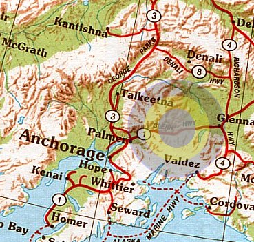
the Matanuska Glacier, located in the Matanuska valley between the Chugach and Talkeetna Mountains in Alaska.

We will use two methods to "see" what is in and under the ice of the glacier. One method is called "seismic reflection"; the other is "ground-penetrating radar". By comparing and contrasting the data collected from seismic reflection and ground-penetrating radar, we hope to accurately map the ground underneath the glacier. In doing so, we will be helping test a hypothesis about how glaciers pick up and carry sediment.

  1. What is shallow stratigraphy?
  2. What is seismic reflection?
  3. What is ground-penetrating radar (GPR)?
  4. Why should seismic reflection and GPR be used together?
  5. Research objectives

What is shallow stratigraphy?
Stratigraphy involves the study of layers of geological materials–both sediment and rocks. Shallow to us means the upper 200 m (about 650 ft) of the Earth’s surface. Because different geological materials are formed and deposited in different geological environments, we can infer the geologic history of an area by examining the type and distribution of these deposits. For example, it is possible to infer the location of shallow faults, oil and natural gas reservoirs, archeological sites, depth to solid rock, old volcanic eruptions or landslides, sink holes, etc.

Shallow stratigraphy can also be used for more practical problems such as helping to plan the location of power plants, chemical factories, and other buildings that require a very stable subsurface. Additionally, shallow stratigraphy can be useful for predicting the likely path of groundwater (and thus pollutants in groundwater).

In the past, the best way for geologists to get information about the geology of the near-surface was to drill many narrow wells and obtain core samples. Today, two common methods of obtaining similar information are seismic reflection and ground-penetrating radar.


What is seismic reflection?
To gather data using seismic reflection, scientists create a seismic wave by shooting a shotgun blank into the ground, hitting a hammer on the ground, etc. Some of the seismic waves reach the geophones (the devices that measure seismic waves) directly, others reach the geophones after bouncing off different layers in the subsurface. By measuring the time delays when the reflected seismic waves arrive, geophysicists can infer the shallow stratigraphy of the area.

Until recently, it was not possible to use seismic reflections to gather data about the near subsurface because the "static" created when the seismic wave was started; geophones are sensitive to sound waves traveling through the air.


What is ground-penetrating radar?
Where seismic reflection uses physical waves to "see" what is underground, ground-penetrating radar uses electromagnetic waves. In other words, ground-penetrating radar relies on the electrical properties of the subsurface.

The steps involved in GPR may be simplified as follows: A transmitter directs an electrical signal into the ground. When the signal reaches an object or layer with different electrical properties, part of the signal is reflected back to the surface. These reflected signals are captured by receivers on the surface. By measuring the time delay between when the signal was sent and when it is received back at the surface, one can infer the depth and location of the object or layer.


Why should the seismic reflection and GPR be used together?
Seismic waves can be used to map the depth of the ice; GPR can be used to map the top layer of sediment trapped in the ice. By combining these data, it will be possible to measure the depth of the sediment layers trapped in the ice.


Research Objectives
Scientists have known for years that glaciers grind rocks apart and transport the sediment great distances. What is less well understood is exactly how the sediment is picked up and carried by glaciers.

Recently, scientists hypothesized the following: as super-cooled water under the glacier rises out of an "overdeepening", it freezes to the base of the glacier. When the water freezes, the sediments carried in the water are trapped in the ice, forming layers of sediment in the glacier. Scientists are not sure their hypothesis is correct because it is very expensive to drill the necessary number of wells (and obtain the necessary number of core samples) to get a reasonably detailed picture of what the ground looks like underneath the glacier. In other words, because they do not know where the overdeepenings are, scientists are not sure if the sediment is, in fact, getting trapped as it rises out of an overdeepening.

Using seismic reflections and GPR, we will gather data to help determine the location of the overdeepenings and, in the process, whether the scientists’ hypothesis is correct.


Be sure to check out the images in the journal entries!

16 June, 2004:

Let the experiments begin!


15 June, 2004:

Sampling at the Arctic Ocean


14 June, 2004:

Hours of daylight: 24 (again!)


13 June, 2004:

Hours of sunlight: 24 (again)


12 June, 2004:

The days are starting to blend into each other;


11 June, 2004:

Word of the day: "tenacity"


10 June, 2004:

Getting Set Up (kind of)


9 June, 2004:

One kind of important detail that I neglected to mention in the previous post:
8 June, 2004:

On our way!


6 June, 2004:

Packing


4 June, 2004:

Meet with Yo: T-3 days


31 July, 2001:

Signing off... for now


30 July, 2001:

More ablation studies and Goodbye dinner


29 July, 2001:

Looking for tombstones and measuring rocks; Data interpretation-Part 2
28 July, 2001:

Visitor from Barrow and Some Technical Information


27 July, 2001:

WebCast and Velocity in ice


26 July, 2001:

Quiet at camp, Data Processing and more GPR


25 July, 2001:

Laundry and Collecting Data


24 July, 2001:

Climbing a hill and Processing Data


23 July, 2001:

New Arrivals and Scouting a Site


22 July, 2001:

Just how warm is it, anyway? and Analyzing data


21 July, 2001:

Picking projects and studying geophysics


20 July, 2001:

Rainy weather...


19 July, 2001:

Outwash, animals GPR


18 July, 2001:

View from top of the Lion's Head Seismic reflections
17 July, 2001:

Mud pits suck ground-penetrating radar basics


16 July, 2001:

Flight to Alaska Arrival at camp


15 July, 2001:

Preparation Reasons for research


8 August, 2000:

Life-long learning and a love of teaching


7 August, 2000:

Arrival!


Return to top of page