19 July, 2001
Outwash, animals & GPR
7:00 p.m.
Life on the ice.... (almost)
This morning after breakfast, Jeff gave a VERY interesting talk about
glaciers and how they deposit sediment. Here's one of the reasons why it's
so interesting: glacial sediments are usually diamictic, that is,
made of pieces that are coarse ("big" pieces like pebbles, gravel, etc.) and
fine ("small" pieces like silt, sand, etc.) When these materials are
deposited at the end or sides of the glacier, rain or river water carries
away many of the small parcticles, leaving the bigger materials behind in an outwash plain. Years later after the glacier retreats, the outwash
plain will filter water and store it; it may become an aquifer. Thus,
the outwash plain is a very useful place to look for water. The Mississippi
River Valley in Illinois, Illinois River Valley, the Mohawk River Valley, the
Sussequehanna River Valley are all in glacial outwash plains that store
tremendous amounts of water that is used by farmers, homes and industry.
After data collection today, Kendra and I went hiking on the glacier for a
couple of hours. Scrambling over miniature mountains of ice and avalanched
sediment and stepping over ice-lined water slides (carved by meltwater), we
discovered a lake hidden at the base of some giant blocks of ice, broken and
pointing skyward. It was magical.
By the way, I have received several comments from readers asking about
wildlife...
Until this morning, I didn't have much to write about except for the
squirrels searching for food from the folks working for CRREL (the guys are
bachelors and don't always clean up their dishes right away) and the raven
who has greeted us from the end moraine on the way to and from the glacier.
This morning on the way to upload my journal and pictures, I spotted a red
fox sitting calmly in the middle of the road, trotting off shortly after s/he
heard me. Around the corner, a mother moose and her calf trotted across the
road in front of me.... another wonder. Bears, Jeff tells me, spend the
summers in the hills, though the ripening wild blueberries may draw them back
down to the valley.
Question (from yesterday) for clever readers: Where else in the
United States might you find a good example of the same thing?
Answer coming tomorrow!
Science at work
Kendra, Greg and I hiked to the same site where we collected data yesterday.
Instead of collecting more seismic data, today we collected
ground-penetrating radar data, traveling over the same line where we
collected data yesterday.
In principle, ground-penetrating radar is relatively simple:
(1) shoot series of radar waves into the ground.
(2) pick up the reflected energy as it leaves the ground, timing how long it
takes to arrive back at the surface and measuring the frequency and
amplitude of the reflected energy.
A similar process is used by air traffic controllers at airports and
navigators aboard ships. While I cannot speak for air traffic controllers
and navigators, the process used by geologists gets to be very tricky very
quickly, and depends on an awful lot of different variables. Interpreting the
data (for both seismic reflections and ground-penetrating radar) is both an
art and a science.
In today's work, we used one antenna to shoot radar waves nearly straight
down into the ground and a second antenna to measure the energy coming out of
the ground 2 m away. The transmitter shot 25 pulses (each one about 0.000
000 000 6 seconds long) of radar waves per second. The receiver measures
incoming energy 160,000,000 times per second. After holding the transmitter
and receiver in one place for several seconds, Kendra and I moved the
transmitter and receiver 0.5 m up the line and repeated the process.
Note: When using ground-penetrating radar, the energy picked up by the
receiving antenna is mostly reflected off surfaces underneath the ground. If
you tried to use GPR underneath a powerline, the receiving antenna would show
an awful lot of static... The electricity traveling through the wire creates
disturbances that can overshadow the sensitive receiver. On the Matanuska
Glacier, the nearest powerline is several miles away, so the transmitted
signal is almost always the strongest one.
Greg is giving the evening campfire talk in a couple of minutes, so ...
that's enough talking for now.
Cheers.
~SM
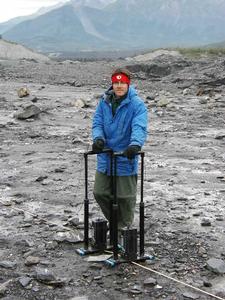
Me! I am holding the antennae so Kendra can take my picture.
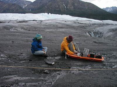
Greg and Kendra are taking a first look at the data we collected today. (Battery and computer were hauled in the Sled of Science )
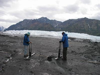
Kendra and I are moving the radar antennae to collect data.
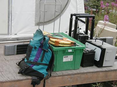
This is the gear we packed to the glacier for collecting ground-penetrating radar data. The battery alone weighs 20 kg!
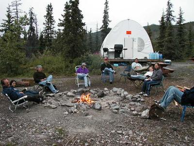
We are sitting around the campfire, getting ready for Greg's evening presentation.
Contact the TEA in the field at
.
If you cannot connect through your browser, copy the
TEA's e-mail address in the "To:" line of
your favorite e-mail package.
|
