|
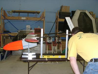
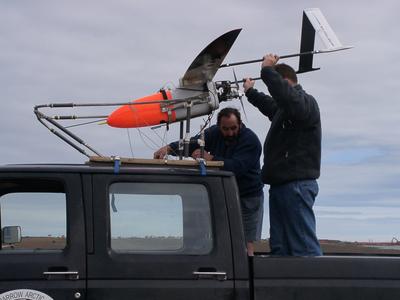
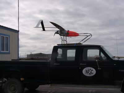
17 July, 2003Thursday Check Aerosonde Mission Diary for updates. Heat wave! 37 degrees, clear and sunny. A good day for flying!! 9 a.m. in the Theatre Final preparations to the Aerosonde for today’s flight include connecting the camera and fixing the sondes onto the wings. The camera focus is set to “infinity” and the resolution is set to medium quality (1025 x 768 normal compression). Images will be taken at about every 25 – 30 seconds during the flight, which will last approximately 5-6 hours. Jim will use the images to make a mosaic of the flight area. A total of about 600 shots will be taken. The images will be saved as JPEG files and then converted to digital GPS. They can then correlated to the flight plan in order how to determine the coordinates for each image. Finding the center of gravity (COG) for the Aerosonde must be done both when the airplane is empty and when it is fully fueled. The COG is the balance-point for the craft, and knowing its location is critical for the stability and control of the airplane. Brett and Dennis use a very simple device (made of meter sticks and a level) and a basic knowledge of geometry to determine the COG. Using a three orientations (front tilt, horizontal, back tilt), they measure from the trailing edge (back) of the wing. The trailing edge is used because it is straight – the leading edge is elliptical for this parcticular aircraft. Each measurement gives points of reference in three dimensions (x, y, and z coordinates). The reference points are feed into a computer, and the COG is calculates. A value above a safe range indicates that the airplane is front heavy and a value below the range indicates that the airplane is back heavy. Weight is adjusted by rearranging the cargo components or, as a last resort, adding dead weight where it is needed until the COG falls within the safe range. The airplane is ready to go, and the plan is to launch at about 2 p.m. and return about 9 p.m. The Aerosonde will fly north about 120 km and then fly a pattern of parallel sweeps about 20 km apart. The KT-11, camera, and sondes will gather data and relay it to the onboard avionics computer. Jim has been busy this morning checking multiple weather websites for forecast information before developing the final mission plan for today’s flight. University of Wyoming Weather Site Radiosonde balloons are launched daily and the results are sent to several weather websites. The readings this morning indicate high humidity and possible ice. The cloud base is between 80 – 300 meters and the wind is S-SE. Jim checks the graphs of air temperature vs. dewpoint temperature and looks for “jumps” in the readings or on the graph that indicates where the cloud layer may be. There is also a wind pattern analysis to be done. All of this data is used to try to determine where icing might start. The problem with using the balloon is that it only gives a picture of a vertical air column as opposed to information over a wide range. There is a low-pressure system (rotates counter-clockwise) and about a 700-ft. ceiling. The visibility is good, which is critical for other air traffic in the area. Pilots must be able to see the Aerosonde as it sometimes does not show up on radar screens. Today’s mission is to find and explore the open water/sea ice boundary and to investigate how air temperature and conditions change from one surface to another. Launch vehicle is a standard pickup truck – launch cradle is attached to the roof and holds the Aerosonde – truck drives down runway at about 55mph and the Aerosonde is lifted from the cradle – the manual pilot takes control and makes sure that everything is working before turning it over to the computer control. Everything went smoothly during launch. Today the Aerosonde is being remotely controlled via radio; the iridium phone will be used for tomorrow’s longer flight. Cold, freezing rain was falling during the landing and the wind had picked up speed. Although it was a little bumpy set-down, everything went well. All that is left to do is to analyze the data. I have learned the hard way that the weather here can change drastically within as little as 15 minutes.
Contact the TEA in the field at . If you cannot connect through your browser, copy the TEA's e-mail address in the "To:" line of your favorite e-mail package. |