|
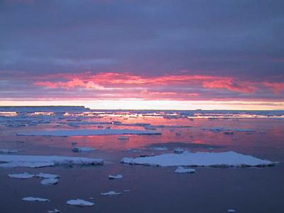
20 February, 2000Clanging in the Cellar February 20, 2000 75 27 S 149 20 W Temp 15 Fahrenheit, wind 5 mph out of the east 4:00 AM, Bright sun shining. Imagine this. You are sitting in your kitchen, and suddenly down in the basement somebody starts rolling empty steel drums around, banging them into each other, the concrete walls, and your oil tank. At the same time, the house gets picked up a few feet off its foundations, shaken and set back down. Again it is picked up, and this time it tilts a little, so you have trouble walking, then comes down with a solid thump Whoever is down in the cellar starts hitting the barrels with a piece of iron bar. This whole scene keeps repeating itself, with no parcticular pattern. Got the picture? Now replace your kitchen windows with port holes, and the doors with watertight ship's doors. Outside the portholes, run a video of white ice floes moving by, and don't forget the occasional penguin or seal. Now you know what it is like to be on the Nathaniel B. Palmer breaking through pack ice off Edward VII land, Antarctica. The experience is unforgettable. The ship's galley is forward and on a lower deck, and the sound of ice scraping by is loud enough to drown out conversation. The ice floes range from kitchen table to football field size, and cover anywhere from half to seven eighths of the sea surface. The ship pushes aside small ones. When it hits a medium sized berg, both ice and ship move, so we are constantly changing direction. When the Nathaniel B. Palmer goes toe to toe with the biggest ones, it has to break them. It does this by riding up on top of them, so that the weight of the ship cracks the ice. Sometimes it has to back up and try a second time. All this results in considerable noise and rocking of the boat. Nearer the land there is "fast ice," unbroken ice attached to the shore. Further out, where we are, the ice is broken and jumbled, with water spaces in between. This is referred to as pack ice. I've heard about pack ice before, but I never really thought about it much until I was here. As you look off the bridge, you see a jumble of white to the horizon, with blue water in between the floes. Sometimes the floes are close enough so you could walk here and there, and sometimes they are separated by gaps too wide to jump. The edges are often pushed up like the edges of a pie crust, from the floes banging together. Most pieces show the original white snow on top, but some of the smaller ones have turned over and look bluer, or sometimes brown from diatoms growing on their lower sides. There are three distinct heights of ice chunks. Most are four or five feet thick, and represent just one Antarctic winter. Slightly thicker ice, ten or fifteen feet thick, comes from multiple winters. By far the highest bergs are broken off pieces of ice shelf. Usually a few of these are in sight, looking like white mesas in the distance. They may extend a hundred feet out of the water. The Nathaniel B. Palmer goes around them! I don't know why, but I was surprised to see tracks and droppings on the ice flows. Penguins and seals come out to rest and sun themselves on the floes, and leave their evidence when they do. Of course, we also see the animals themselves. Usually they just watch us go by, but occasionally, when the ship is close enough, they wriggle, slide, or swim away. If you spend fifteen minutes watching from the bridge, you are sure to see some animals. I understand now why Shackleton's men had such a difficult time trying to travel in the pack ice. You would spend all your time getting in and out of boats, and dragging them. In the long run you would have to do as they did, and "go with the floe." We are not just joy riding around, though. We are following and mapping the edge of the continental shelf, termed the 'shelf break." The continental shelves are relatively shallow, but at the shelf break the water deepens rapidly. Many scientists believe that during glacial maximums, like the one fifteen thousand years ago, the Antarctic ice sheets extended all the way to the shelf breaks. Nobody has an accurate idea of where the breaks are in this part of the world, so on our way to Pine Island Bay we are mapping them. To do this mapping, the Nathaniel B. Palmer has a special kind of sonar called a SeaBeam. (SeaBeam is a brand name. Other companies make similar devices.) The basic principle of the SeaBeam is just like that of a fish finder or depth sounder. It sends sound energy down to the bottom and times its return. What makes the SeaBeam and similar systems different is that they in effect send a variety of beams in different directions, so that with computer processing they can actually draw a map of the bottom as the ship goes along. We see that map on a computer screen in the dry lab. The width of the strip mapped varies with depth, but in 2000 feet it would be three or four miles wide. So as we ride along in the pack ice, we can "see" what is below us. Think of it like this. Imagine you are in an airplane flying along above a uniform layer of clouds. You can't see the mountains, valleys, cities and lakes below you, just the cloud tops. Now suppose that the airplane had a magical device which would erase the clouds right below it as it flew along. You would see a ribbon of ground below you. If you were trying to map the edge of a lake, you could fly along, turning the airplane left or right as you went. If you drew a map of where the airplane had gone, you would know the shape of the lake. That's just what we're trying to do, mapping the shelf break. Of course there's a catch. The map that comes out on the computer monitor is a rough map. To get a better one, the data has to be edited to remove stray noise signals. Every few seconds, the SeaBeam pings. In an hour, there might be 900 or 1000 pings. Especially when breaking ice, many of these pings have extra noise. To get the finished map, we look at the pings one by one on a computer screen, editing out bad portions with a mouse. It is called, oddly enough, ping editing. Everybody shares in this job. It is about the only really boring thing about life here! Yesterday I was so tired I fell asleep doing it. I'm still not done with yesterday's file, and I've got a whole new one for today. I better get to it.
Contact the TEA in the field at . If you cannot connect through your browser, copy the TEA's e-mail address in the "To:" line of your favorite e-mail package. |