|
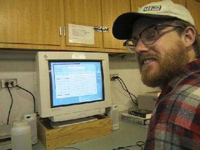
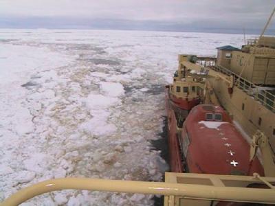
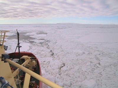
21 February, 2000Backing and Ramming February 21, 2000 74 15 s 141 20 w (Off Hobbs and Ruppert Coasts of Marie Byrd Land 10:30 PM, Overcast, dark except for orange glow on the horizon. Wind out of the east at 8 mph, temperature 17 F All day today we've been trying to work our way east along the Antarctic continental shelf, towards the Amundsen Sea and Pine Island Bay. Our path has been a meandering one. In pack ice conditions one doesn't just set a course and follow it, as you would in open water. The trace of our course looks like the path of a mouse investigating a new cage! Earlier today I was up on the bridge. Around us was an almost unbroken expanse of white ice pack, mostly last winter's ice. I saw occasional tall icebergs, and a very few dark cracks, called leads, of open water or thin new ice. It looked like the ship was in the middle of an endless snow covered field, with a few hills and streams. If I had my snowshoes, I could travel miles. Near the big bergs there is often an interesting pattern in the sea ice. What you observe is a trail of broken ice leading away from the berg, a lot like the broken ice ribbon behind the ship. It's as if the berg, like the ship, was sailing through the pack ice under its own power! Of course bergs don't have diesel engines, so why do they leave tracks as if they are moving? I think I've got an answer. Write me and tell me what you think. Incidentally, some of the biggest bergs may be big enough to be scraping or stuck on the sea floor, even though the water is over a thousand feet deep. About one sixth or one seventh of a berg is above water. A berg showing 150 feet above the water might be big enough to be grounded. Some of them look that high. If I had a handy little submarine I could go down and look. I guess the submarine would have to have a bright light, because it is pretty dark down there. Some whales and seals dive that deep looking for lunch. We saw a whale, maybe a Minke, surface briefly in an open crack today, a shiny black back in the bright white ice. If I could speak whale I'd ask it (her? him?) to follow the side of an iceberg down, and see if there was space to swim between the ice and the sea floor. Regretfully, we have temporarily given up trying to follow the continental shelf break (see last journal entry.) The ice won't allow it. Now we are just trying to reach a more open area of the pack ice, so that we can get eastward to our prime objective, Pine Island Bay and the Amundsen Sea area. We'll try to get there by whatever route we can. It has been slow going today, and several times we've been forced to resort to backing and ramming. The ship goes forward until stopped by the ice, and then backs up for a tenth of a mile or so. Then it's full speed ahead, pick up a little momentum, and smash into the ice again. Sometimes it only takes a crunch or two to get to the next patch of easier ice, but a couple of times we were at it for a half hour. The noise of the engines and the ice breaking is impressive, as is the rolling of the ship. When the propellers hit pieces of ice, the whole ship shakes and things rattle. One time, while we were butting the same place over and over, two emperor penguins stood some distance away watching. I wish I knew what they were thinking! Near the stern of the ship is a room called the aft control room. The controls for various winches, and a lot of other levers and dials are located there. I don't touch any of them. Most of the time the aft control room is not in use, so I go back there to play my fiddle. It's very important to be respectful of other people on a ship, and I don't want to annoy anyone with my squeaking and screeching. I like this room because it has a splendid view. I was fiddling away this afternoon watching the rush of water from the ship's two big propellers as we rammed ice. The thrust of the props, and the ice lifting the bow pushed the stern down. The torrent looked like river water rushing through rapids during spring melting. Car sized chunks of ice came out from underneath the stern, turning over and over, while the water built up against the floes on either side. Speaking of having a view, I've been learning about views from space. Of course we would like to know where there is open water or looser ice, so that we can get further east. We can see a lot from the ship's bridge, and even more if we climb up into the ice tower above the bridge, a cozy little crow's nest reached by three ladders. Still, we are in such a big field of ice that getting a little higher doesn't help much. A helicopter would be great, but it stayed at McMurdo. To the east, near the horizon, the clouds have dark bottoms. I'd like to ask the crew if that means water, but they seem busy and I don't want to bother them. What I do have is some satellite images. Dr. Shusun Li of the University of Alaska at Fairbanks is aboard. As I mentioned earlier, part of his task here is to help "ground truth" or interpret ice images from a new orbiter. He and his group dig pits on ice floes to study the structure of the snow and the ice. They also have some other fancy instruments they use, which I mean to learn about. I want to go out and work with them soon if I can. Dr. Li showed me two kinds of images we can receive on ship, which help us find our way. One is simply a black and white picture from space. The other is a microwave image, made by a satellite bouncing 85 GHz radar from space. On both of them, I can see a clear area to our east. The prevailing easterly winds have blown all the ice to the west side of Wrigley Gulf (where we are), while the east side (where we want to get) is ice-free. The clear area on the images can't possibly account for the dark sky I see, because it is much too far away. So much for my theory! I asked Dr. Li about the advantages of one type of image over another. Why do we need microwave radar when the regular photos show things so clearly? He pointed out the obvious answer. Microwaves can see through clouds and at night. In Antarctica, there are lots of clouds and six months of darkness, which means a lot of times with no visible light image possible. The problem with microwave images is that microwave "light" sometimes gives confusing information. For example, rough water can look like snow or ice, and vice versa. I can see this in the two images I have in front of me. They both show clear water in the same places. The microwave image shows ice detail in a large area covered by clouds in the visible light picture. But the microwaves also show a large open water area sixty miles inland from the coast of Antarctica, up on the ice cap, where there couldn't possibly be a lake! These images must be available on the Internet. Does anyone know where? We are now back tracking, trying to find an easier way to the Amundsen Sea. I'll keep you posted.
Contact the TEA in the field at . If you cannot connect through your browser, copy the TEA's e-mail address in the "To:" line of your favorite e-mail package. |