|
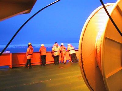
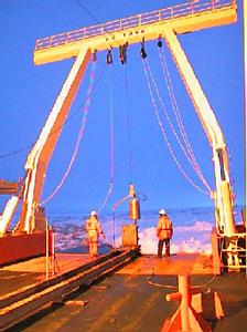
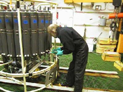
24 February, 2000Russkaya Station February 24, 2000 73 31 s 132 33 w Off Hobbs Coast near Forrester Island Temp 2.8 C (27 F), Wind 15 km/hr (9 mph) out of the south Barometric pressure dropping Overcast and foggy We are in the middle of what in the old days would have been referred to as a "trackless waste." Like yesterday and the day before, there is floe ice in every direction as far as the eye can see (even when it is clear.) In odd moments my mind goes back to tales of early explorers. The wind would push the pack ice against their ships, breaking them like nuts in a nutcracker. Then the people would be forced to fend for themselves in a place where you can't walk, row or sail very well, and distances are measured in hundreds of miles. Speaking of distances, we are about 80 km (50 miles) away from shore and about 1900 km (1180 miles) from the nearest habitation at McMurdo base. There may be people closer, a ship or an airplane, but no station or camp. We are about 180 km (112 miles) from the now abandoned Russian Base of Russkaya, at the bottom of Mt. Gray. I don't know why, but the idea of being close (in Antarctic terms) to some place of human construction fascinates me. I asked people on the Nathaniel B. Palmer about the base. They said it had been closed for at least ten or fifteen years. It was evidently very difficult to keep supplied. Food, fuel and other supplies had to be offloaded on fast (semi-permanent) ice, and then transported to the station itself. One year the supply ship stayed too late and got trapped in ice at the station. An icebreaker had to come from Vladivostok, a Russian port in the North Pacific, to break it free. The supply ship was not freed until July, in the middle of the Antarctic winter. I imagine now Russkaya station must be a cold, empty place, with maybe a door or window banging in the wind, and things just as people left them years ago. Of course that's just a guess, because we can't see it from here! Stan Jacobs can remember when weather reports used to be relayed from Russkaya. Now, except for the occasional passing ship, there is no weather reporting for the whole coast between McMurdo and the Antarctic peninsula (get a map and check it out!) The United States has a station at Siple, but it is only occasionally occupied. The lack of weather information for this area harms climate studies, because a great deal of the moisture for the Antarctic continent enters in these longitudes. Later in our trip, we will place three automatic weather stations as part of a German study, but they are not expected to last for an extended period. We are back up on the continental shelf, and we seem to have gone around the worst of the ice. We are going to go eastward and find what looks like a large area of relatively open ocean, look for the position of the shelf break, and any glacial troughs. We have a few tantalizing hints of where glacial troughs might be, from previous voyages. We hope to find more. Knowing their size and position helps determine the extent of past ice caps. We stopped to take a CTD and a piston core this evening. The crew pushed the bow of the ship into a big floe, and ran the engines to blow clear an area around the stern. This gave us space to lower the CTD and corer (see today's pictures.) In a future journal, I'll explain more about piston coring. What I had not seen before was how water samples were taken from the CTD. So, after it had been returned to the ship and was firmly tied down in the Baltic room, I went to watch. Remember that the water from various depths was being tested for, among other things, helium isotopes, and chloroflourocarbons (CFCs). Dee Breger, is a specialist in electron microscopy from the Lamont Observatory of Columbia University, and has published a beautiful book of electron microscope images. She isn't on this trip to run a microscope, though. She is the one collecting samples for helium isotope analysis. If you recall a previous journal entry, I told you that certain helium isotopes were produced by atmospheric hydrogen bomb tests in the 1950s and 1960s. The winds blew these isotopes worldwide in a short time, and they mixed with ocean surface water everywhere. When these isotopes are found at deeper depths, it is an indication that the water with the isotopes was at the surface when the bomb tests were being conducted. It might surprise you to know that, although water in any one layer of the ocean mixes continually, mixing between layers takes a long time, sometimes many years. Sometimes oceanographers say that water has a certain "age." They are referring to how long it has been since that water was at the surface of the sea, and able to replenish its oxygen supply from the atmosphere. Dee Breger explained to me how she took the samples. She attached a hose to a spigot at the bottom of one of the bottles on the CTD. The other end of the hose was connected to a section of copper tubing. When she opened the spigot, water ran out through the hose and the copper tubing. When she was sure all the air bubbles were out of the tubing, she sealed each end by squeezing it with a clamp. The samples were then ready to be stored and tested for helium later, on shore. She explained that she used copper because it had a crystal structure tight enough that helium, a light, small molecule, could not get in or out of the sample. Guy Mathieu, also from Columbia University, was taking the samples for CFCs. The picture with this journal entry shows him in the Baltic room. He is carefully drawing samples with very large scary looking glass syringes. Guy told me that CFCs are another good indicator of how "old" water is. They are man made chemicals, manufactured since the 1930s. There are several different types, and tests can tell the difference between the types. He said the amount of each type sold in different time periods is known from manufacturer's records. By looking at the ratio of types in a water sample, tests can tell if that water was on the surface in, say, the forties or the sixties. He said that the only ocean water on earth without CFCs is deep water in the North Pacific Ocean. There are also other samples being taken, but I'll have to find out about them later. It is time for me to go ping edit, and stand geophysical watch.
Contact the TEA in the field at . If you cannot connect through your browser, copy the TEA's e-mail address in the "To:" line of your favorite e-mail package. |