|
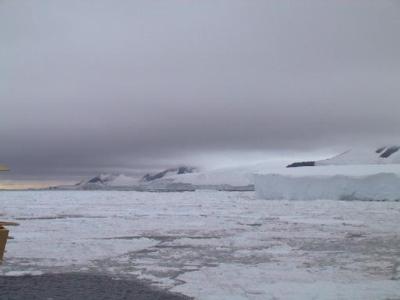
26 February, 2000Beyond the End of the World 73 53 s 127-26 w 300 m (984 feet) from edge of Getz ice shelf Water depth 728 m (2388 feet) Temp. 2.7 C (27 F) Wind 20 km/hr (12.5 mph) from the east Barometer 982 mb, steady Low overcast, open water How would you like a nice place to get away from it all? No teachers, no tests, no classes, no McDonald's, no electricity, no phone, no soil, no heat, no light for six months of the year, and no company for long periods of time. We passed a place today that is about as desolate and forbidding as any I've seen. There are a couple of islands, Shephard and Grant, mostly buried in the Antarctic ice cap, but having some of their seaward faces exposed. If you turn around and look backwards, you can see the end of the world from them! This morning I saw them in the distance, and when I woke up we were closer. The ship passed a few hundred meters from their shorelines, giving all on board (at least those who were awake) a good view. The sight of solid rock brought people out on deck. It's a change from snow, water, ice and sky. Between the island and us the sea was half covered with a jumble of all shapes and sizes of ice floes, tumbling along in the current. You might think that these islands were discovered some time in the late nineteenth or early twentieth century. You would be wrong. Shephard Island was found by air around 1940, and Grant Island wasn't discovered, or at least recognized as a separate island, until 1962. From the point of view of the human race, this is a new part of the world. Charts of this section of Antarctica are often inaccurate. The first mapping of this coast was done in the 1940s and 1950s from air surveys. Long before Global Positioning System (GPS), survey flights determined positions by astronomical observation, which is difficult and prone to error in airplanes. The islands are shown in different places on different charts, their positions varying by as much as fifteen miles. The shapes of the islands also vary from map to map, probably because it is difficult to tell precisely the shape of an island when it's underneath several hundred feet of ice. Furthermore, looking at them from the seaward side, it is difficult to tell where one island begins and the other ends. To the south (inland) of them the ice cap rises, and both are largely buried under ice. What one sees is a long coast of ice, before, after, and at the islands. The only difference is that where the islands are some solid earth sticks out. We only see the bottom few hundred feet of the slopes. The rest is hidden in low stratus clouds. The solid earth generally takes the form of jet-black volcanic rock, arranged in twisted layers and outcrops. The steepest slopes are the ones that are most likely to be exposed. Most of the visible rock seems to be covered with a slightly lighter colored material, pinkish brown in color. I wonder if it is guano from penguins or other birds, or perhaps the start of a thin soil covering. The guano might have a pinkish tinge from the krill in surrounding waters. Through binoculars from the ship, there is no sign of birds or plants, living or dead. There are icefalls in the valleys, deeply crevassed areas of almost vertical slope, where the ice tumbles slowly to the water's edge. At the bottom of some outcroppings black boulders litter the snow, rolling almost to the water. Where ice has calved off below the slopes, a cross section is exposed. Thick layers of white snow alternate with thin layers of black rock. Along this forbidding coastline, I see only one place where a small boat could be landed. It is a section of beach, or maybe rounded rock, about a tenth of a mile long. It is covered with the same pinkish material, and directly in back of it there is a wall of ice. Two other places stand out, both literally and in my memory. We pass two flat north facing headlands, each about the size and color of a supermarket parking lot (without the yellow lines). They are almost snow free, scoured by the wind. Each is surrounded by one hundred foot black cliffs, descending sheer to the sea. If you wanted to get away from it all, you could bolt your sturdy cabin to the rock there, and live a hermit's life. Nobody would bother you for a long time. Answer to yesterday's question: Why is the area near the ice shelf more likely to be free of ice than the ocean further out? Probably the major reason is off shore winds. Cold air sinks over the middle of Antarctica, and flows generally outward from the shores. As it does so, it blows ice seaward. There are some other possibilities, including currents along the shore, warm water rising from below, and tides, that might be important at certain times also, but winds are the major reason.
Contact the TEA in the field at . If you cannot connect through your browser, copy the TEA's e-mail address in the "To:" line of your favorite e-mail package. |