|
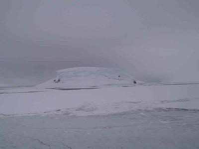
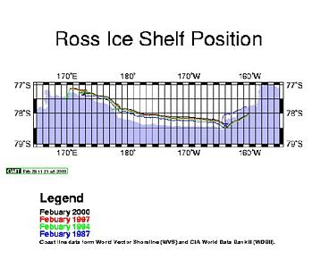
28 February, 2000A New Island, More on Mud, and Creeping Ice 72 30 s 124 24 w North of Getz ice shelf, over continental slope Depth 1139 m (3737 ft.), on CTD station Wind 25 knots (29 mph) out of SW Temperature 3 C (27 F) Barometer 973.2 MB, steady Open water, occasional ice floes It's nice to think that, even in the year 2000, there are still new islands to be found on earth. We just found one! After returning from the shelf break, we were moving along the north shore of Siple Island. On satellite pictures we'd seen a large area of fast ice breaking away, leaving a thirty or forty mile long open crack we could follow. We were looking for the west end of that crack. You would think that with all our navigation equipment and charts we could know exactly where the ship is, and exactly where the crack is, and be able to get there. It is not that simple. We can tell exactly what latitude and longitude we are with GPS (Global Positioning System) equipment. The problem is that when we see something on a satellite photo, we can't tell its position very closely. It is hard to find landmarks in the photos. If we do recognize something its position isn't always known accurately. We have charts that say things like "Mt. Siple, Maher and Lauff islands reported to lie about 32.5 miles W by S of charted positions (1981)" or "Extent and shape of bay unknown." Because of these uncertainties, we found ourselves searching in a maze of large icebergs, trying to decide which open looking area might be the start of the crack. Captain Joe Borkowski was on the bridge, guiding the ship carefully, binoculars in hand. I went up in the ice tower, with the "seal people." We were looking for penguins, seals and whales to count for their population study. We noticed what we at first thought was an iceberg. Something about its shape looked a little odd. Icebergs come in all sorts of shapes and sizes, but somehow this didn't look like one. We noticed some dark places on its side. It's not unusual for an iceberg to have rocks or dirt in it. Ice picks up these things as it slides along bedrock, and when it breaks off as an iceberg, it takes them with it. As we got closer to it, we began to study it through binoculars, and try to decide if it was really an island, or just a dirty berg. As we were doing this, a crewmember came up from below to have a better look at it. He said that on the bridge they were having the same discussion. Was it an island or a berg? As we pulled up nearer to it, we finally all agreed that it was an island. The black parts were outcrops of volcanic rock. Ice and snow capped the top to an unknown depth. We slowly approached within a ship's length of the shore. Even though we were within 100 meters of the island, the water depth was still 185 meters! I think the island must be an old volcanic neck sticking straight up from the bottom. A volcanic neck is simply the hardened magma in the "pipe" or central channel of a volcano. All the ash and lava flows around erode away, leaving a tall pillar. There's a picture of the new island with this journal entry. It isn't a tropical paradise like Tahiti, but it is an island nonetheless. It's location is about 73 22 s and 125 37 w. I've heard that the Captain wants to name it after his unborn grandchild. What a thing, to have an island with your name on it before you are born! Yesterday I was telling you about how we take cores here on the ship. Now that you understand a little bit about coring, let me try to explain some of the things that Dr. Tom Kellogg wants to do with the mud. The principal reason he wants the mud is to tell how old it is, with carbon dating. Many scientists think that all the sediment was scraped away down to bare rock when the glaciers expanded before the height of the last ice age. If we find out how old the mud nearest bedrock is, we will know when the ice first left the area, and new sediment was deposited. Another way people can test mud is to see how big the gravel, sand or clay parcticles in it are, and how much of each size there is. Dr. Dan Belknap of the University of Maine will do this part of the study when the cores get back to Maine. If sediment is deposited a long way from shore, for example, it tends to be very fine grained. If you rub some between your fingers, it just feels greasy, not gritty. This kind of sediment is called glacial marine. Currents are not strong enough to carry heavy sand or pebbles far from land. When we were looking at the new island, we at first thought it might be a "dirty berg." Ice that was part of a glacier or was formed near a shore often contains sand, gravel and rock. This material is carried out to sea, and eventually drops to the bottom when the ice melts. Sometimes you find a rock in the middle of very fine sediment, and you can guess it probably got there by dropping from floating ice. Rocks like this are called 'ice rafted debris" or "drop stones." A third reason we want sediment is to look at the microfossils in it. Tiny fossils such as diatoms and foraminifera are often found in sediment. Scientists can make good guesses about the environment from these fossils. I told you in an earlier journal entry about Dr. Davida Kellogg and diatoms. One of my special interests is foraminifera, little animals with calcium carbonate shells, about the size of the period at the end of this sentence. I studied them when I was a graduate student, and I've been looking at some from our cores. I'll tell you more about them in a later journal entry. There are lots of other things you can tell from sediment cores. You can do chemical analysis, you can x-ray them, or study their very weak magnetism. I've got a question for you, though. What kind of sediment do you suppose is deposited way in under an ice shelf. Would there be diatoms and foraminifera in it? Would it be coarse and sandy? Or fine and greasy? Let me know what you think. I want to tell you about one more thing being studied on board the Nathaniel B. Palmer. It is pretty easy to understand what is happening, but nobody is sure why it is happening. While we were sailing along the edge of the Ross Ice Shelf a week or so back, we all took turns using a radar scope to get the range, or distance between the ship and the ice shelf. Since we knew the position of the ship, we could then tell exactly where the shelf edge was. We wrote this down every fifteen minutes or so, night and day, for as long as we followed the shelf edge. Jesse Johnson, a graduate student at the University of Maine, wrote a computer program to take all these positions and plot them as a line on a map. On the same map, he plotted the positions for three other recent years. The purple shaded area at the bottom dates to the sixties or the seventies. The other data for past years came from Stan Jacobs, and a New Zealander named Harry Keyes. The plot he got is shown in a picture with this journal entry. I apologize if it's small and hard to read. It had to be that way so I could send it to you by satellite. But even as it is, you should be able to see what is happening. The Ross Ice Shelf edge is extending more and more seaward each year, and probably has been doing so for more than thirty years. Its floating outer edge moves seaward between one half and one kilometer per year. It's pretty obvious that this is happening. The big question is why. Various people on board have different opinions. Here are some possible reasons: a) Maybe it does this all the time and once in a while, maybe every fifty years or so, you have a season when for some reason, perhaps storms, a lot of ice breaks off all at once. Then the whole process starts over again. b) Maybe for some reason a lot more snow than before has been falling on the ice cap, so it is building up and causing the edges to flow out faster. c) Ablation means the direct vaporization of ice by sun or wind. Maybe ablation is decreasing, so not as much ice is being lost that way. This would have the same effect as increased precipitation. d) Maybe the bottom of the ice sheet is wet from melting, so it slides downhill and out onto the water faster. This could happen if the amount of heat coming out of the earth is increasing for some reason. e) Sea level is rising so maybe the grounding line, the place where the ice first floats off the bottom, is moving back toward the land. When ice is floating, there's not much holding it back. When it is resting on rock, friction holds it back. f) Maybe it is a combination of two or more of these things. This journal entry got long! There's a lot to think about here. Myself, I'm thinking about going to sleep now.
Contact the TEA in the field at . If you cannot connect through your browser, copy the TEA's e-mail address in the "To:" line of your favorite e-mail package. |