|
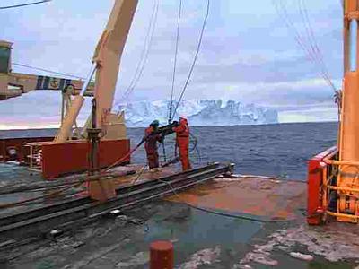
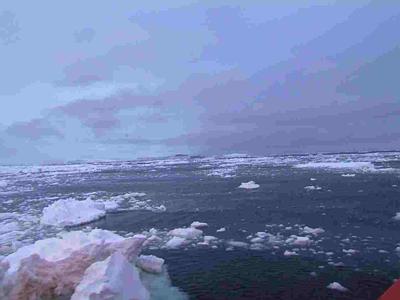
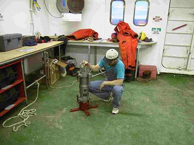
2 March, 2000The Sound of One Bubble Collapsing 74 04 s 117 37 w Off Wright Island, Amundsen Sea Temp -5.1 C (23 F), was -19 C (-2 F) 3 hours ago Winds 40 Knots (46 mph) out of South Barometer 974 Mb, dropping Depth 1016 m (3333 ft) 1 m (3.3 ft) breaking cross chop seas Limited visibility in blowing snow I don't know exactly when you will read this. The satellite by which our e-mail is transmitted is below the horizon, so we are unable to transfer data. We should be in range in a day or two. I haven't yet seen a clear, starry sky here. It's either too light or cloudy. I'm wondering how many satellites will be visible. I haven't seen an airplane since we got off the C-141 in McMurdo. The Amundsen Sea is not on many flight plans. We've been cruising down the coast of Wright Island, which looks a lot like Carney Island. Occasionally I see honest to goodness rock cliffs at the edge, so I know that there is island in there above sea level. Both islands look like large, very smooth piles of ice, rounded and gradually rising towards the center. The big smooth mounds are lit up by patches of sunlight. You could walk for a day up there, to get from one end of Wright Island to the other. Along the northern edge, the one we are paralleling, the smooth contour comes to an abrupt end. Fifty to one hundred meter cliffs pitch down to the water, or to attached fast ice. You could have a nice five km ski or snowboard trip down the slope, but you had better be able top stop before the edge. I once heard a Kiswahili proverb that says: "The running stops at the edge of the roof." Maybe it could be modified to: "The skiing stops at the edge of the ice cap." Our data gathering has continued as before. The last two piston cores we took held some surprises. One came up with a nice 2.5 m (8.2 ft) core, but the lower end of the core pipe, the cutting edge, was destroyed. The cutting edge is a heavy steel collar screwed onto the pipe. It was split down one side and pushed back up over the pipe. We guessed that the core either hit bedrock or a large boulder. Fortunately, we've got lots of spares aboard. The second core was in fairly shallow water, and hit a place where there was a lot of gravel. In the whole core barrel we got only a few cm of rocks and sand, but the trigger core came up with pieces of an unsuspecting clam, which probably never knew what hit it! We've got a new (to me) device we're using to gather information about the bottom. It's called an "air gun." Using it is referred to as "running seismic." What we get from it is a continuous record, not only of the depth below the ship, but also of the layers of sediment and rock below the bottom. As we cruise along in 800 meters of water, we can "see" what's 100 meters below the bottom on a paper chart in the dry lab. The principle is simple. The heavy stainless steel "gun" is towed behind the ship, hung a few feet below the surface by chains attached to a buoy. A compressed air line and electrical control wires go to the gun. Every few seconds, a computer on the ship sends a signal to the gun and a valve opens. A big bubble of air comes out of the gun. Of course this makes a noise in the water (sometimes you can hear it from the deck.) The noise goes down to and into the bottom. It bounces back from the bottom and sub-bottom layers, and comes back up to the surface. There it is received by an "eel" towed behind the ship This eel is nothing but a 100 m long plastic tube holding many microphones. These microphones are connected to a computer on the ship. The computer carefully listens to them all, thinks the whole thing through for a quarter of a second or so, and then draws a picture of the sediment layers on a roll of paper, as we go along. What is the difference between the air gun and the SeaBeam I was talking about in an earlier journal entry? The SeaBeam sees only the bottom, not below it. Its advantage is that it can show a wide swath along the bottom, as much as several kilometers to each side of the ship. The air gun images only what is directly below the ship, but it can look several hundred meters into the bottom. What can we see in the air gun seismic record? When the bottom is bedrock, we see a dark black trace, going up and down as the water depth changes. When the bottom has sediment, we see what looks like little ponds above the bedrock, which are actually large depressions filled with mud. Occasionally we see rock strata below the bedrock. This information helps us find good places to take cores, where we know there is enough mud. The seismic record also helps determine what areas are scraped clean by currents or glaciers, and which ones were relatively calm and undisturbed. The other morning when the sun was out we were testing the air gun, and I went out on the aft deck to watch it. Every few seconds, I could see a flash in the water. Of course the air gun doesn't use gunpowder. What I was seeing was the glint of sunlight on the silvery air bubble in the blue water. What puzzled me was that the flash seemed to have two parts. Each flash was made up of two flashes one after another, with only a tiny fraction of a second in between. At first I wasn't sure of what I was seeing, but I looked carefully, and again and again there was the two part flash. I filed it in the back of my head and forgot about it. Later, Craig Huhta, our shipboard air gun seismic expert, took some of his time to explain the basics of the system to me, so that I could keep watch on it. When he was explaining how the air gun worked, he told me something about the bubble it produces, and all of a sudden I realized why I saw those two closely spaced flashes. When the air gun releases air, the bubble expands rapidly, until the pressure inside is actually lower than the pressure in the water around it. At this point, the bubble collapses inward. If it were allowed to do this, it would make a second noise as the void in the water collapsed. That second noise would be loud enough to bounce off things and confuse the computer, which already has enough to think about. What the air gun does to prevent this is interesting. Right after the first air is released, just as the bubble is collapsing, the gun injects a lesser amount of air into the space, to quiet the collapse of the bubble. He showed me this on an oscilloscope in the dry lab. I could see a pip made by the first noise. He momentarily shut off the second air pulse, letting the bubble collapse uncushioned. When he did this, the pip of a second sound, the "sound of one bubble collapsing", appeared on the screen after the first one. It reminded me that there was a lot going on around me, and it was worth looking at things carefully and thinking about them. As I finish this, we're out by the continental shelf edge, 30 or 40 km offshore. We've taken a seismic record for the entire length of a glacial trough. I've been watching the print out on the paper roll. What is just as amazing is the view outside. We passed a six mile long berg in the first light of dawn. I looked out and thought we were back by the ice shelf, and I had to go back in to look at our position on the chart. As the sun rises, we're pulling the air gun out of the water, to get ready for a CTD station and coring. Check out the picture with this entry, and you can get an idea of what it looks like. Answer to the question posed several days ago: What kind of sediment gets deposited under and ice shelf? In general, we see very fine grained sediment without diatoms or foraminifera. There is no sunlight (the ice is too thick) so diatoms, being plants, cannot grow. Therefore the animals like foraminifera which depend on diatoms are not there either. The only kind of sediment is very fine grained clay, which can be carried long distances by slow currents.
Contact the TEA in the field at . If you cannot connect through your browser, copy the TEA's e-mail address in the "To:" line of your favorite e-mail package. |