|
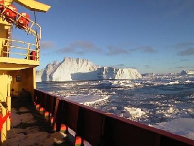
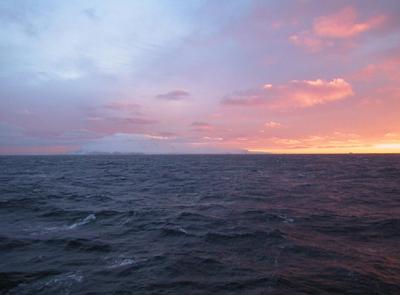
24 March, 2000Scope For the Imagination 69 02 s 90 52 w Off Peter I Island Temp -6 C (21 F), wind SW @ 30 knots (35 mph) Barometer 998 mb steady Depth 2674 m (8771 ft.) Open water except for 9 large bergs in 360 degrees 4 m (13 ft.) seas, some tops blown off We're in transit now, headed directly for Palmer Station on the west side of the Antarctic Peninsula. It is about a three day trip northeast. The Nathaniel B. Palmer can cruise at about 11.5 knots, a little more than 13 miles per hour, so we have time to look around. I want to look around at birds, since there are lots of them about, different and more varied than the pack ice birds. Even though we are in transit, we still continue to record scientific data. Yesterday we stated to record magnetic data. The magnetic data we gather is simply the strength of the Earth's magnetic field in different places. Three hundred meters behind us we drag an instrument called a magnetometer, connected by a cable to a computer that records the information. Scientists at the Scripps Institute of Oceanography in California have an agreement with some research vessels to gather magnetic data whenever the ships are in transit in open water. The data helps them unravel the history of sea floor spreading and continental drift. Our knowledge of the ancient super-continent of Pangaea, and its daughters/sons Laurasia and Gondwanaland, comes in part from sea floor magnetic data. Remember that plate tectonics tells us that ocean crust is created at mid-ocean ridges, and that the ocean bottom spreads away on either side of these ridges. The further you get from the ridge, the older the crust. You may also know that the Earth's magnetic field switches polarity every once in a while. In other words, the north magnetic pole and the south magnetic pole switch places. (If this switch were to happen today, the north-seeking needle of your compass would point down near where I am now.) Ocean crust forms from lava at the mid-ocean ridges. When this lava hardens, it "remembers" the magnetic field, reversed or normal, that was present when it cooled. The remembered imprint is called residual magnetism. Because the sea floor spreads from the mid-ocean ridges, this residual magnetism shows up as symmetrical ribbons on each side. By carefully mapping the patterns of residual magnetism on the ocean floors, scientists can estimate positions of continents long ago, and predict where they will be millions of years from now. Magnetometers have been used for a long time to find submerged submarines because the subs disturb the Earth's magnetic field. Military sub detection specialists knew about magnetic banding of the ocean floor before its cause was known. The magnetometer is really a coil of many turns of fine copper wire mounted in a bullet shaped pod full of kerosene. Kerosene is chosen because it has a lot of hydrogen atoms. Normally the hydrogen atoms line up with the Earth's magnetic field. Every few seconds a short pulse of direct current is sent from the ship to the coil. When that happens the coil acts as a magnet and lines up all the hydrogen atoms in a different direction. As soon as the current stops, the hydrogen atoms tend to return to their old alignment. As they do so they precess, or wobble like little tops. When they do so, they create electricity in the coil and send a signal back to the ship. The stronger the Earth's magnetic field, the quicker they precess and the higher the frequency of current generated. Thus the computer can read the strength of the magnetic field. If it is a little less than normal, then the Nathaniel B. Palmer is probably over an area with reversed residual magnetism, and vice-versa. The computer automatically records the data, but we take readings every few minutes and note them on a clipboard. I've seen some patterns in these readings, but I'm not sure if what I am seeing is experimental error, magnetic banding, or random noise. Since we aren't coring or casting CTDs, we are on skeleton watches now, only three hours per day each. This gives me time to catch up on e-mails, do journal writing, and prepare samples and data for the end of the voyage. My watch is from midnight to three in the morning. Sleeping late would be nice, but this morning I asked watch mates to wake me up at six so I wouldn't miss our pass by Peter I Island. I love maps, and for years I've looked at Peter I Island, wondered about it and longed to see it. Up until a few months ago, I thought I never would see the place. With the possible exception of Bouvet Island, it's the most isolated open ocean island in the world. It is largely glacier covered, 18 km (11 mi.) long and 8 km (5 mi.) wide. It is about 325 km (200 mi.) northeast of Cape Braathen on Thurston Island. The island was discovered in 1821 by the Russian explorer Thaddeus Bellingshausen, who named it for Peter the Great. Lars Christensen Peak, the highest point on this volcanic island, is 1755 m (5756 feet) high. Prior to the Antarctic Treaty, the Norwegians claimed the island and maintained automated weather stations there. The photographer Eliot Porter, in his book Antarctica, gives an account of landing on Peter I. See if your library has a copy. Dawn finds me standing out on the bow with several others, plunging three meters up and down with each roller. The cup of coffee I drank when I woke was a calculated risk; it might improve things, or it might work the other way. Fortunately, we're headed downwind, and the bow is sheltered from the worst of the wind by the ship's superstructure. We get lots of fresh air but we're not too cold. The island appears to port and ahead of us, a thin gray smudge on the gray sea. The sun rises and quickly disappears into the clouds, but for a moment it lights up the peak and the top of a cloud layer cutting the snowy slopes. The island is a big white mass surrounded by rock and snow cliffs descending into the sea. A few small black rock outcroppings break the snowy dome higher up. Through binoculars, I can find no place to land a boat, except for one very steep rocky beach backed up by an ice cliff. The chart shows a slightly gentler slope on the far side; perhaps that is where the few visitors land. More likely, they helicopter to the few relatively flat areas. Our visit is short. Soon Peter I Island is falling astern. Now only the bottom third is visible, the top hidden by gray stratus clouds. The GPS tells me there is 664 nautical miles (764 mi.) of open water to Palmer Station. Ahead there is just sea, the line between water and sky, clouds, and patches of blue. I look back and the island is disappearing. Not many ships come this way. When was it last seen and who will see it next? When was the last time somebody stood on the peak? Will my eyes ever see it again? Peter I Island is a desolate spot in a vast wet wilderness. What scope for the imagination!
Contact the TEA in the field at . If you cannot connect through your browser, copy the TEA's e-mail address in the "To:" line of your favorite e-mail package. |