|
|
4 March, 2000
Where a Cold Tongue Isn't
74 18 s 109 22 w
Northeast of Bear Peninsula
Mt. Murphy visible in the distance
Breaking new ice @ 6 knots (7 mph)
Wind 20 knots (23 mph) out of the south
Temp 24 C (-11 F)
Barometer 995 mb, steady
Depth 940 m (3084 feet)
We just finished coring, and I'm warming up. Outside, in the
predawn, the scene is weirdly beautiful. Those who live by the seashore in
cold climates may know the look of a mudflat at low tide on a bitter cold
winter morning. It would be, well, flat, and covered with a skim of ice.
The ice we're pushing aside here looks like the mudflat ice. The only
difference is that there are no trees or houses on the shore. In fact
there's no shore, unless you count Mt. Murphy's dark shape in the distance.
Instead of trees and houses imagine icebergs scattered about, each larger
and taller than the ship, some close, some further away. Their northeast
faces catch the orange glow in the sky, but the parts facing the cold south
wind from the ice cap are dark. Another thing: mudflats begin at the shore
and end at the water's edge. This ice surface begins at one horizon and
ends at the other.
It is getting cold here, not as cold as it will get in May, June
and July, but chilly nonetheless. If you figure the temperature and the
wind, you get a wind chill index somewhere in the 40 to 50 range, and those
temperatures are about the same in centigrade and Fahrenheit. The
temperature makes coring harder. The corer breaks a hole in the slushy ice
and disappears into the water. Underwater, it is 23 C (43 F) warmer than
the air, but still cold enough to take your breath away if you went
overboard. We go inside and wait while it is lowered, watching a TV
monitor. The monitor shows the depth, how many meters of cable are out, how
fast it's going out, the tension on the cable, and our position. We want to
know as close as possible when and where the core hits, and how hard the
winch has to pull to get it out of the mud.
When the core is back on deck, we work fast to get the outside mud
cleaned off before it freezes. Even though the deck is heated, muddy slush
freezes underfoot. Hoses, noses, and toes freeze. The bolts, pins and
screws that hold the machine together work harder, and my insulated rubber
gloves get so rigid I have to take them off and work bare handed.
We get the core free, and three people carry it into the relatively warm
lab. Then we go outside, put an empty core box onto the weights, and clean
up the deck as well as we can.
As soon as the corer is on deck and chained or bolted down, the
ship gets underway to head to the next station. I like to watch the ice as
the ship smashes through it. Each kind of ice looks and acts differently.
That is something that would never have occurred to me before I got here.
Ice was just ice, and ice breaking ships broke it, that's all there was to it!
This morning, we are breaking through 10 cm (4 inch) new ice. "New" means
it has just formed, probably within the last few days, maybe within the
last few hours. You could safely walk on 10 cm freshwater ice, but I don't
know about this stuff. Although it looks solid, the bow wave of the ship
easily flexes the ice surface. Yesterday we came upon some new ice that had
been pushed up against a larger flow by the wind, and frozen in permanent
waves.
The ship tends to cut new ice, rather than break it. A few meters away
cracks appear running in the direction of the ship's travel, maybe started
by the bow wave. Then, pushed outward by the sides of the ship, the cut
part near the ship slides under the rest of the ice. We leave a neat trail
of double thickness ice on each side. Even at twice the thickness, I
wouldn't try walking on it.
One thing I'd like to see that I haven't seen yet is a clear dark
night with a starry sky, and maybe the Aurora Australis, the southern
lights. Actually, I think it would have to be one or the other, because the
aurora brightens the sky so much that many stars are not visible. On a
starry night I'd see a different sky than I'm used to in Maine. Polaris,
the north star, would be way below the horizon. I've got a little southern
hemisphere star book with me and I hope to get a chance to use it. I'd like
to see the Aurora Australis to compare it to the Aurora Borealis, the
northern lights. Last September I was camping in Newfoundland and Labrador
with a group of Liberty School students, and we were treated to quite a
display. We sat up late, watching the sky wave and flicker.
Now comes the part about the cold tongue.
If you have a map of Antarctica that shows much detail at all, look at the
area centered on 74 S, 108 30 W, about 32 km (20 miles) from the tip of
Bear Peninsula. That's about where I am now, give or take a few km. You'll
see an oval shaped feature about 113km (70 miles) long and 32 km (20 miles)
wide. If it is named, it will be called the Thwaites Iceberg Tongue. It was
the mother of all possible ice cubes, a large section of the outfall of the
Thwaites Glacier. Its northern end is shown tipped slightly to the west,
and its southern end close to the Thwaites Glacier Tongue.
Notice I say "was." The Thwaites Iceberg Tongue is there no
longer. It's gone. It was there for at least seventy five years, since the
first human beings saw these empty shores. It was noted in the thirties,
mapped in the forties and again in the seventies. In 1976 there was about 5
km (3 miles) separating it from the Thwaites Glacier Tongue to the south.
In 1986 or 1987, the whole Thwaites Iceberg Tongue floated off to see the
world. It drifted for about 100 km (60 miles) and then once again became
grounded, this time on the outer continental shelf. (Remember that in
Antarctica, unlike most other areas, the continental shelf may be shallower
at its outer edge.) Later still the berg broke into two pieces. The larger
one floated free and followed the western edge of the Antarctic Peninsula
northwards. Recently, it has made news as a hazard to shipping, floating
about the Drake Passage, the open water between Cape Horn and the Antarctic
Peninsula. It is somewhat reduced in size, but still voyaging far from its
place of birth. I don't know what became of the smaller of the two pieces,
but I suspect parts of it at least are still around.
Some questions come to my mind. Why was it there to begin with? And if it
was there so long, why did it all of a sudden float off one year? Why do
satellite photos show an area about the same size covered with fast ice
there now? Why was the top tilted to the west, instead of lined up with the
Thwaites Glacier Tongue? Does the fact that this huge chunk of ice broke
off and drifted away have anything to do with global warming or sea level rise?
Some I can answer, some I can't, and one I'll leave to you. The tongue was
there to begin with because Thwaites Glacier is a fast moving one, as
glaciers go. Satellite data indicates that the ice slide down hill and out
onto the sea at as much as 2.9 km (1.8 miles) each year. That means if you
built a cabin on the glacier nine miles inland, in five years it would be
ocean front property. This huge mass of ice just flows out on to the
continental shelf. The inland part probably floats, but by the time the
iceberg tongue got to its mapped position, its northern part at least was
aground. Why did it then float away? A good guess is that "warm," meaning
1-2 C (33-35 F) water melted away enough of its bottom layers so that it
was thin enough to float, and did. It was still quite thick, several
hundred meters, but when we say "shallow" water in this sense we mean a few
hundred meters. That is well over your boots.
Do these events come from global warming, or have big pieces like this
always broken off from time to time? Nobody really knows, although lots of
people have opinions. That's part of what the Nathaniel B. Palmer is down
here to find out.
Where the Thwaites Iceberg Tongue used to be, there is now an area of fast
ice. We are following the western edge of this multi year ice north, taking
cores, doing CTDs, counting seals, and studying snow as we go. Remember
that "fast ice" means multiyear ice that is usually more than 2 meters (6.6
feet) thick, as compared to icebergs and ice shelves which are 100 meters
(328 feet) or more thick. Another thing about fast ice: it is stuck to the
shore or grounded icebergs. It's fast meaning stuck, not fast zoom zoom.
Why is this new ice here? The same satellite image shows lots of little (1
km long) icebergs embedded in the fast ice. They are probably grounded
where Thwaites Iceberg Tongue used to be. They serve as anchors, holding
the thinner floating ice in place.
Why are the northern tips of both ice formations "leaning" west?
I'll leave that for you to guess. Write me an e-mail and tell me what you
think.

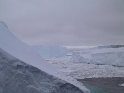
"Little" icebergs, considerably bigger than the ship. We wandered in a maze of these trying to find the west end of a big ice-free crack north of Siple Island.

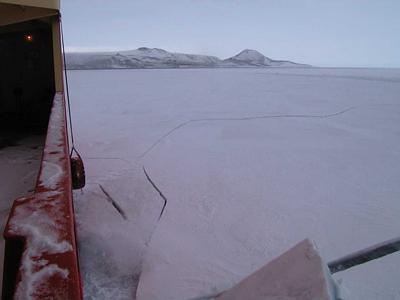
The Nathaniel B. Palmer breaking ice. This isn't the new ice I was talking about: it's probably a year or so old and a meter thick. Notice the crack going off away from the ship, like a crack in breaking glass. Older ice breaks in an entirely different way than new ice. The ship slides up on top of old ice and smashes the ice with its weight.

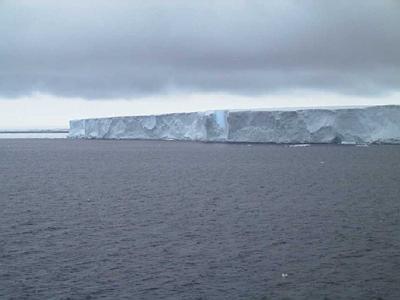
A grounded iceberg with a patch of fast ice attached to it on the left. Look about half way across the front of the iceberg and you will see a large piece about to "calve," in other words, fall off. It will make a big, cold splash when it goes.
Contact the TEA in the field at
.
If you cannot connect through your browser, copy the
TEA's e-mail address in the "To:" line of
your favorite e-mail package.
|
