|
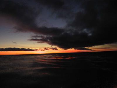
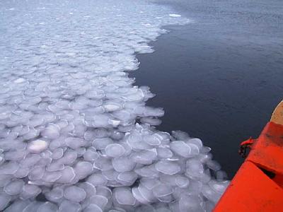
6 March, 2000"Warm" Water, Deep Down 73 03 s 121 59 w ~84 km (52 miles) north of Cape Leahy, Duncan Peninsula, Carney Island Depth 571 m (1873 ft) Wind 7 knots (8 mph) from the east, Temp 7 C (19 F) Barometer 985 mb, falling slowly, leaden overcast sky Ship headed NW at 11.8 knots (13.6 mph) Cruising through grease and pancake ice, occasional open water Widely spaced large bergs, old and worn, one looks like the Matterhorn, another like a two mile ship. Whales occasionally surfacing, too distant to tell species Last night I was up on the bridge during the "mid watch" which is to say, the wee hours of the morning. As I've noted before, it is a magical time to be there. It's quiet and dark, with only the dimmed lights from the radar, radios, and other instruments. The spotlights search the sea ahead for bergs, but find only six foot waves with wind torn tops, and chunks of broken floe. The diesels rumble way down below my feet, and the bridge sways in the dark (only the nicest little bit of THAT will do just fine, please and thank you!) The mates talk quietly. It's a scene that is as old as ships and the sea, except that in long gone times an oil lamp replaced the electronic glow. On a TV monitor I watch the output from the SeaBeam. In the course of three or four minutes the water deepens substantially. A half mile below the ship's keel the bottom is dropping away fast. We're crossing a glacial trough where there should not be one, halfway out on the shelf. We've mapped both inshore and seaward from here, and there was nothing but flat shelf, so where does this ice ditch come from, and where does it go? Here is something new to wonder about. Because we aren't breaking ice, things are quieter than usual. We are offshore in the dark, so I can't see ice shelf edge, cold black rock, or floe. This is a more familiar seascape. Antarctica seems to lose its eeriness when I'm out of the sight and sound of ice. It is dark enough to see stars, so I get on my parka and go out on the bridge deck to see if there are holes in the clouds. Even though it has warmed a little since yesterday, the 10 C wind finds small openings in my clothes and invites itself in. I look up, and there, high above me in a gap in the haze, is the Southern Cross, almost directly overhead. As I watch and it comes and goes, and then there is a relatively large clear patch and the two southern pointers, Alpha and Beta Centauri appear. They point at the cross. I look over to the north, and as I watch the sky clears there also, and I try to make sense of the pattern of stars revealed. It seems a familiar arrangement, but I can't name the constellation. Then I realize it is Orion the hunter, upside down, in the north! It's not where I am used to seeing it. I look back at Alpha and Beta Centauri. The first is a double star, composed of orange and yellow companions. I forget, but I think Beta Centauri it is a single star, like our sun. They are both close in star terms, 4.3 light years. Proxima Centauri, at 4.2 light years, is the closest to the sun. I can't find it in the haze. I think it is only a matter of time before people move out into space, and head for these or other nearby stars. It is in our blood, to explore, to move on to new places. Of course the laws of physics limit us, but patience and commitment to live and die in space will serve us on our long journey. Someday, and I think it will be within a few generations, people on the bridge of a real spaceship will leave for those stars, and will talk quietly, exchanging confidences on the mid watch. Maybe some of my great grandchildren's children will be aboard. I hope so. I 'm too cold to stay out on deck any longer. I go inside and down two decks to take my clothes out of the dryer, and of course there is a sock missing. Some things are truly universal. When that starship heads for Proxima Centauri, it will no doubt be equipped with a sock-eating dryer. Before I forget it, I left you with a question in my journal for March 4, and I didn't answer it yesterday. Better late than never, so I will now. The question asked why both the Thwaites Iceberg Tongue and the fast ice that replaced it are tilted westward at their northern ends. The answer is that the prevailing winds are from the east in these parts, and those winds blow both types of ice to the west. Presumably, although no one knows because no ship has ever been there, there is an area of relatively shallow water which grounds icebergs there, so they can't drift any further. Why do the winds here generally come out of the east or southeast? Remember air generally rises over the warm equator and sinks over the poles. Sinking air blows outward from the center of Antarctica to the edges. Instead of blowing straight north, it turns to the left or west (in the southern hemisphere), because of Coriolis force. So in these latitudes, the prevailing winds blow from the east to the west. If you look at yesterday's (March 5) journal, you will see a CTD plot. It is raw data, which needs to be further processed to be accurate, but it shows general trends. I explained how to read it, and asked you to try to explain the patterns. Take a look at it again. First look at the temperature, the black line. It is coldest at the surface, where cold winds off the ice cap cool it. The water warms a little at about 50 meters. It stays somewhat constant down to about 300 meters, and then gets significantly warmer, if you can all -0.75 C warm. The temperature increases slightly until about 625 meters depth, when it takes a quantum leap from 0.5 to +1 C. Then it stays nearly constant all the way to the bottom. Look at the blue line, which shows oxygen. It seems to follow a pattern opposite to the temperature. It is highest near the surface, because the water can absorb oxygen from the air above. Look at what happens at about 625 meters. An abrupt drop occurs at the same depth as the temperature rise. Salinity shows a sharp rise at that same depth, and then, like the others, remains constant to the bottom. What Stan Jacobs sees below 600 meters is evidence of what is called Circumpolar Deep Water, a finger of it that has gotten up onto the continental shelf where we took the CTD. One of the reasons he is down here, and taking all these CTDs, is to look for this parcticular water mass. What do I mean by the term "water mass?" It is merely a volume of water that is more or less uniform in temperature and salinity. The water you see below 625 meters on the CTD is a water mass, because it has a recognizable, fairly constant salinity and temperature. A water mass may be only a few hundred meters thick, but it covers hundreds of thousands of square kilometers. Doesn't water mix at the edges, and eventually become all the same? Yes it does mix, but not significantly on an ocean wide scale. Circumpolar Deep Water is the largest water mass in this part of the world, circulating around the continent of Antarctica, below the surface but above the bottom. It has its origins far to the north, in the North Atlantic Ocean, where winters make surface waters so cold they become dense and sink to near the bottom. The sunken water moves southward, crosses the equator, and turns into Circumpolar Deep Water here. Eventually, it loses its identity by mixing with glacial melt water here, or heading up into the North Pacific, eventually to be brought to the surface by winds and density differences. There is even denser water in the Southern Ocean, the Antarctic Bottom Water, although you don't see it on the CTD graph I've given you. Antarctic Bottom Water forms in the Weddell Sea, on the other side of the Antarctic Peninsula It is so dense it sinks to the bottom and flows north, underneath the southward flow described above. It is much too dense to get up on the continental shelf. For some reason, nobody seems to know, Circumpolar Deep Water reaches up on the continental shelf much more in the Amundsen Sea than it does near the Ross Sea. Over by McMurdo Station, you can find Circumpolar Deep Water out beyond the shelf break, but not in shallower water. So what? What does this water have to do with anything else? Why bother to take a ship (burning 5-9 thousand gallons of diesel per day) down here to investigate it? Remember I told you that Thwaites Glacier moved fast in glacial terms, almost two miles per year in some parts. There's a possibility that this fast movement may be part of a larger picture, a draining and destruction of the West Antarctic Ice Sheet, which could lead to a sea level rise of 3m (20 ft) in the years ahead. If you live near the ocean, go down and stand by the water's edge. Look around for a nearby building or tree that is three or four times the height of your eyes. The water will be up to the top of that tree if the ice sheet melts. The Circumpolar Deep Water may be a major factor melting ice here. The Circumpolar Deep Water is warm, at least compared to other waters. That warmth may account for rapid bottom melting, as much as 13 m (42.6 ft) per year, of the glaciers and ice shelves. (Was this why the Thwaites Iceberg Tongue floated away?) When this happens, glaciers may move even faster. Eventually the ice all flows out and melts, and the land many people live on now disappears below the sea. It's all tied together. So it is definitely worth the trouble and expense to come down here and study the Circumpolar Deep Water, in addition to it being a neat thing just to know about! Speaking of knowing, I wish I knew what became of my other sock. Guess I'll go look for it again.
Contact the TEA in the field at . If you cannot connect through your browser, copy the TEA's e-mail address in the "To:" line of your favorite e-mail package. |