|
|
18 July, 2001
Transit to Lomonosov Ridge
Wednesday, 18 July 2001
Valkommen! (Welcome!)
Life on Board
It was cloudy, drizzly, and breezy today. We are getting into much thicker
ice and doing some serious icebreaking. It is actually harder to sleep
when the ship is breaking ice than on any other portion of the journey.
Imagine trying to sleep in the back of an old pickup truck. You are
traveling along a dirt road, complete with washboards and potholes. Oh,
there are also large anthills sporadically placed in the road.
Occasionally there are patches of smooth, leftover pavement, just long
enough to lull you into thinking that you are on a highway. Fairly often,
the driver swerves violently to avoid large rocks, and is seldom
successful. If he can't make it over the trees that have fallen across the
road, he backs up and makes another run at it, full speed ahead and pedal
to the metal.
We did get to see a mother bear (unfortunately called a sow) and cub on the
ice but didn't slow down for a closer look.
Where Are We Now?
The plan is to make a transit directly for the Lomonosov Ridge, where the
seismology group will be making soundings. This ridge, rising above the
surrounding ocean floor, is approximately 1,100 miles (1800 kilometers)
long. It roughly divides the Arctic Ocean into two parts, one side
distinguished by Atlantic Ocean water and the other side by Pacific Ocean
water (Richard Vaughan, The Arctic: A History). It provides a site of
great interest to oceanographers trying to understand the circulation of
water and air in the Arctic, which affects the entire global climate. It
will take us approximately one week to reach the Ridge. Our last station
was Marginal Ice Zone (MIZ) Station 9, about 5 pm, 83o46' North/31o59' E.
I hope we actually have an Ice Station Zebra for all of you Alistair
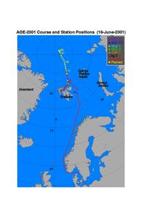
McLean/Sean Connery fans out there. I will try to post an image of the
completed and planned cruise track with this journal entry. You will be
able to see how close we will be to the North Pole by then.
Scientists at Work
We are still taking seawater samples every other station from the sampling
rosette/CTD. My group uses what is called a Secchi disk to make an
estimate of the clarity of the water. The disk is a white circle of metal,
approximately a foot in diameter, attached to a rope that is marked off in
meters with tape. The scientists lower it over the side of the ship while
we are on station and watch it as it descends, counting the meters of rope
that go into the water. When the disk is no longer visible in the depths,
this represents where only 1% of the light is available. This is the
bottom of the euphotic zone, where organisms like to concentrate. If there
are many organisms in the water, this zone is closer to the surface of the
water. Knowing this information, the scientists then decide what depths to
collect water samples to look at the organisms. In this Arctic water, the
bottom of the euphotic zone has been about 100 meters each time we have
checked with the Secchi disk, so even though the sampling rosette may go
down much further, we only take water samples from 100 meters, 20 meters,
and surface.
Vi ses! (See you later!)
From Deck 4 on the Icebreaker Oden, somewhere northeast of Spitzbergen,
Dena Rosenberger

Dots represent stations with longer stations numbered.
Contact the TEA in the field at
.
If you cannot connect through your browser, copy the
TEA's e-mail address in the "To:" line of
your favorite e-mail package.
|
